How is this observed? This summer, my country has a textbook-like "violent plum blossom"
Since the beginning of the plum rain season this year, the weather in the Yangtze and Huaihe River basins in my country has shown the characteristics of particularly concentrated precipitation, heavy rainfall, and very little sunshine. Meteorologists believe that this year's plum rain belt in my country is textbook typical, commonly known as the "violent plum rain".
However, not every plum rain season goes as planned. In some years, there will even be an empty plum rain season.
According to relevant personnel from the China Meteorological Administration, there are differences in the temporal and spatial distribution of plum rains in my country, with obvious regional characteristics. In the 1990s, precipitation was mainly high; from the late 1950s to the 1960s, and from the late 1990s to the first decade of the 21st century, precipitation was low. Since 2010, with global warming, the weather during plum rains in my country has become more unstable and extreme, which has also brought more challenges to my country's meteorological forecasting work.
As weather conditions become increasingly unstable and extreme situations occur more frequently, accurate monitoring will become increasingly important for meteorological departments.
In novels, wise men often observe the celestial phenomena at night and gain insight into the secrets of the heavens. In real history, every dynasty has an institution such as the "Sitianjian" and the "Qintianjian" to undertake the important task of observing celestial phenomena.
"Now, we can observe celestial phenomena with the help of radar." Wu Lei, director of the Radar Application Room of the Meteorological Detection Center of the China Meteorological Administration, introduced that weather radar is like an observatory for observing clouds and rain. It uses the radar antenna as a telescope and radio waves to observe rain and snow conditions thousands of miles away.
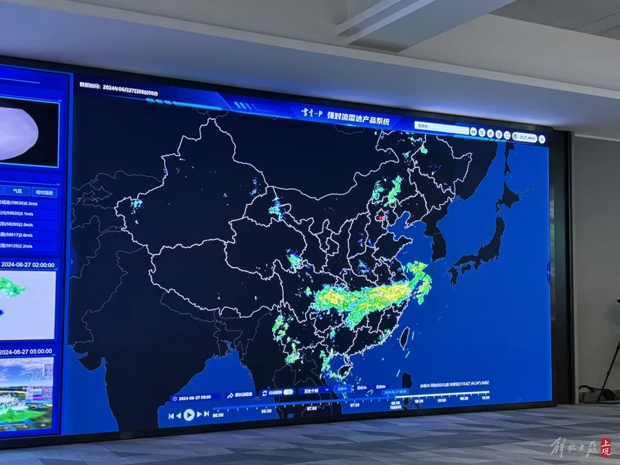
On the big screen of the Meteorological Detection Center of the China Meteorological Administration, the reporter noticed that a very obvious plum rain belt appeared on the radar map, and the real-time data next to it told us that the middle and lower reaches of the Yangtze River in my country are being hit by heavy rains.
Large screen at the Meteorological Observation Center of the China Meteorological Administration, photo by Zhang Yu.
How was this "textbook-style" plum rain belt observed by radar? Wu Lei introduced that under different precipitation intensities, the size and density of water droplets vary, which makes the rainwater's scattering ability for electromagnetic waves different. Generally speaking, large water droplets have stronger scattering ability than small water droplets, and a piece of water droplets has stronger scattering ability than a single water droplet. Therefore, when the weather radar actively emits electromagnetic waves in a certain direction and encounters precipitation, the raindrops will scatter the electromagnetic waves, causing the radar to receive an echo signal. The greater the energy received, it usually means that there is more rain in the sky.
"In meteorology, we are accustomed to using the sum of the sixth power of the particle diameters per unit volume as the output result, which is called the reflectivity factor. Through the reflectivity factor, we can preliminarily judge the intensity of precipitation," said Wu Lei.
However, with just the reflectivity factor, we can only know whether it is heavy rain or light rain, but we cannot know how the raindrops move with the wind. This requires Doppler technology, that is, by analyzing the slight frequency shift characteristics of the precipitation echo, we can get whether the precipitation is approaching or moving away from the radar. "The speed of approaching and moving away from the radar is the radar radial velocity. Using the radial velocity, we can get the state of atmospheric motion in the sky." Wu Lei said that based on the physical characteristics of the shape and movement speed of precipitation particles observed by radar, through scientific analysis, weather radar can monitor and identify the occurrence and development characteristics of disastrous weather to protect people's lives and property.
For example, on April 27, the first strong tornado of EF2 intensity this year occurred in Baiyun District, Guangzhou. From 14:06 on the same day, Guangzhou radar detected the development of a supercell in Huadu District, with hook echoes and mesocyclone features; at 14:48, the supercell moved to Zhongluotan Town, Baiyun District, and the tornado vortex features continued to alarm; at 15:00, the tornado was collected, about 12 minutes in advance.
Since June 17, heavy rainfall has continued to occur in southern my country, causing many places to break historical extremes. The national radar network has also monitored precipitation in the Jianghuai region, and can also qualitatively understand the location and approximate intensity of precipitation through radar reflectivity. "If you want to quantitatively understand how many millimeters have fallen, you will use the 1-hour quantitative precipitation product inverted by radar, which displays precipitation in a gridded manner. The blue area indicates ≥25 mm in 1 hour, and short-term heavy rainfall may occur locally." Wu Lei said.
At present, the China Meteorological Administration has formed four major categories of radar product systems, including basic products, physical quantity products, identification products and extrapolation products. Among them, hail, thunderstorms, short-term heavy rainfall and tornadoes that are more familiar to the public are included in the identification products.
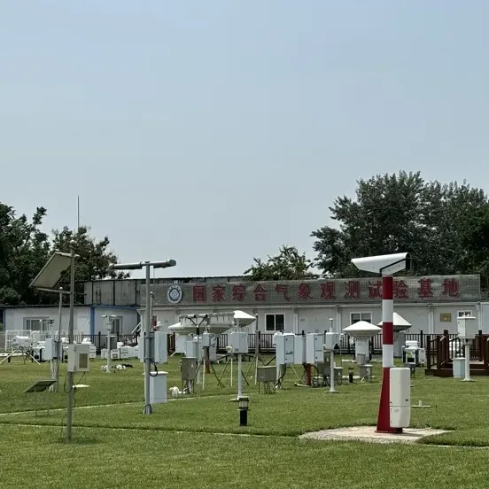
my country has built 252 new-generation weather radars
my country calls weather radars that have introduced Doppler technology the new generation of weather radars. So far, my country has built 252 new generation weather radars, which are mainly divided into S band and C band.
Zhang Tao, chief forecaster of the Central Meteorological Observatory, introduced that different bands refer to the different wavelengths of the emitted centimeter waves, such as the S wavelength is 10 cm, the C wavelength is 5 cm, and the X wavelength is 3 cm.
At present, the S-band radars built in my country are mainly distributed in coastal areas and major rainfall basins, while C-band radars are mainly distributed in inland areas. In recent years, in order to make up for the detection blind spots of the new generation of weather radars, both the national and local governments have begun to invest in the construction of X-band weather radars. "Compared with S-band radars, X-band radars are smaller in size and are generally deployed close to the ground," said Zhang Tao.
A new generation radar device 52.7 meters high.
In the southern suburbs of Beijing, the reporter saw a 52.7-meter-high white tower, on top of which was installed one of the only two S-band radars in Beijing. Wang Hui, a senior engineer at the Beijing Meteorological Detection Center, said that this S-band weather radar was put into operation in 2006 and provided support for the meteorological service guarantee for the 2008 Beijing Summer Olympics. "It can detect precipitation cloud characteristics within a radius of up to 460 kilometers, and the radial velocity of precipitation or cloud particles within a radius of up to 230 kilometers. It also has high accuracy and stability in detecting cloud precipitation particles, hail, thunderstorms and gales, and even tornadoes, and can meet the monitoring needs of large-scale weather systems."
In 2021, Beijing invested in its second S-band weather radar to ensure the smooth holding of the 2022 Beijing Winter Olympics. "This S-band weather radar not only provides strong support for the meteorological service guarantee of the Winter Olympics, but also effectively monitors the weather system in the northwest of Beijing, and plays an important role in the short-term forecast and warning of severe convective weather in summer," said Wang Hui.
After years of construction, Beijing has formed a multi-band weather radar network with S-band radar for large-scale warning monitoring and X-band radar for fine detection, including 11 weather radars, including 2 S-band radars and 9 X-band weather radars. In order to effectively monitor the occurrence and development of weather systems in the upstream areas of Beijing, relevant departments have also deployed 3 X-band weather radars in the upstream Hebei Province.
"This radar network can conduct coordinated monitoring of disastrous weather around the clock and in all time and space," said Zhang Hongji, director of the Beijing Meteorological Observation Center.


![Why am I still willing to stay in Hong Kong?, [Personal experience] Shanghai residents in Hong Kong: Mandarin after the Cathay Pacific incident | Cathay Pacific | Airlines](https://a5qu.com/upload/images/5a3e15fa370397b4295d66aae51154b1.jpg)