Is there an unidentified flying object appearing over Shanghai? The meteorological expert's science popularization is here
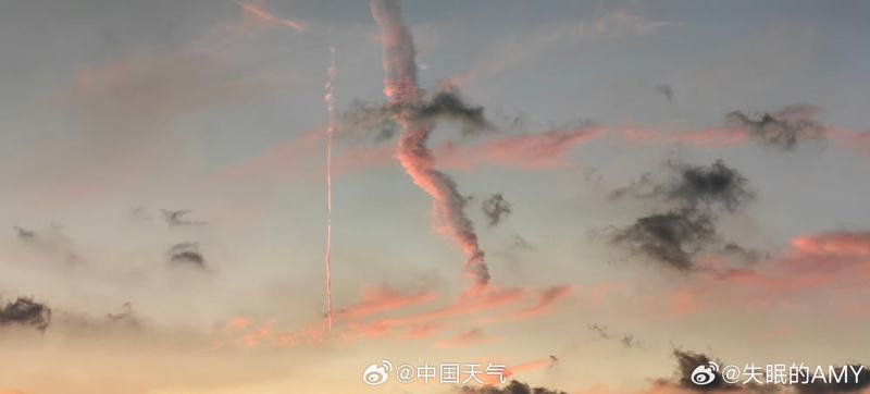
On September 1st, the sunset in Shanghai attracted the attention of citizens. At the same time, residents of Baoshan discovered a "unidentified flying object" suddenly appearing in the sky, falling at high speed like a fireball, and uploaded footage, causing a heated discussion among netizens.
Weibo @ China Weather Reply Netizens
In response, the Public Meteorological Service Center of the China Meteorological Administration posted on its official Weibo account, stating that it resembles a "wake cloud of an airplane"; The Shanghai Meteorological Bureau also speculates that it may have been formed after the diffusion of wake clouds.
Wu Rui, an expert from the Shanghai Meteorological Bureau, responded to the Shanghai debunking platform that based on the photos provided by netizens, there is a high possibility of wake clouds. However, rigorous astronomical judgments require more evidence, such as the need for aviation and other relevant departments to confirm the route passing through Baoshan at that time.

Images captured by netizens
It is understood that wake clouds are commonly known as "airplane smoke". People often see jet planes flying at high altitudes in clear skies, with one or several long "cloud bands" appearing behind the fuselage. In fact, this is not smoke emitted by jet planes, but a special cloud system formed by the condensation of water vapor from the exhaust gases emitted by the aircraft and the surrounding air. It is called airplane wake in the aviation aviation industry and aviation meteorology.
How wake clouds form
Meteorologists and civil aviation experts have stated that the exhaust gases emitted by jet aircraft engines actually contain a lot of particulate matter, which can easily form condensation nuclei.
After high-temperature exhaust gas is discharged at an altitude of 6000 to 10000 meters, it quickly condenses in the cold high-altitude atmosphere, forming water vapor. If the air itself has sufficient water vapor and the temperature and pressure are appropriate, these new and old water vapor will form clear cloud bands around the condensation nuclei.
Trail cloud characteristics
Aircraft wake clouds do not exist for too long and usually disappear quickly, but when conditions are favorable, they can exist for more than an hour and can expand into a wider cloud layer. The seasonal variation of aircraft wake height is not very obvious, and overall, it occurs more frequently in the winter half year than in the summer half year. The average thickness of the wake layer ranges from 1 kilometer to 2 kilometers, with the lowest lower limit height in winter and the highest in summer. In thicker aircraft condensation wake, the length and concentration of wake formed at different heights also vary. Usually appearing at the bottom is a shorter and lighter concentration wake, which gradually lengthens and becomes thicker upwards. After reaching a certain height, it then turns back into intermittent light colored wake.