Designed and developed independently by Hangzhou enterprises, China's first "artificial intelligence satellite" has successfully launched computing power | intelligence | enterprise
In the science fiction movie "Wandering Earth 2", the artificial intelligence robot MOSS undergoes multiple iterations and possesses self-awareness. In real life, recently ChatGPT emerged, and the strength of artificial intelligence models surprised everyone. In the aviation field, in the era of artificial intelligence, Earth observation satellites also need to grow a "brain".
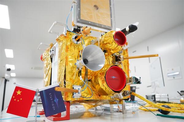
At 12:03 am Beijing time on August 10, 2023, China's first intelligent emergency satellite with artificial intelligence payload as the core and intelligent operating system, "Geosatellite Intelligent Emergency 1", was successfully launched and entered the designated orbit at the Jiuquan Satellite Launch Center. This satellite was independently designed and developed by Zhejiang Hangzhou Enterprise Earth Satellite II Space Technology Co., Ltd.
Unlike traditional remote sensing satellites in the past, this satellite can achieve on-board AI capabilities such as semantic understanding, in orbit recognition, intelligent segmentation, intelligent compression, invalid data cleaning, and large model inference. The implementation of a series of ultra-high computing power is thanks to the company's independently developed on-board intelligent load processing unit "Xian", which provides network support for nebula computing power with "sky and ground computing together".
If traditional remote sensing satellites only carry cameras and sensors as the "eyes" to see the Earth, this satellite also comes with a "super strong brain", which can perform 80 trillion floating-point operations per second with billions of transistors. Taking satellite images of 10000 square kilometers as an example, intelligent satellites with strings only need a few hours of in orbit processing to achieve dynamic target extraction. The traditional satellite method usually takes 180 days.
"In this way, many intelligent applications can be directly implemented on satellites," said Wen Zhuoming, CEO of Europa. For example, you can have it identify all the peaks in China and use algorithms to count the quantity or calculate the degree of greenery in an area. Even when you're bored, you can ask it to take a beautiful night view photo, and it will shoot according to the composition it finds attractive.
On the intelligent platform of satellites, various intelligent applications can be operated and verified on spacecraft, empowering various scenarios including forest disaster reduction, water quality monitoring, soil moisture, non agricultural and non grain, forest fire points, disease and pest monitoring, urban violations, etc. High precision monitoring methods have unique advantages, and data can be directly sent out when needed.
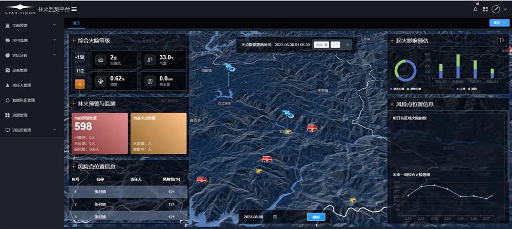
Schematic diagram of the Skyinsight software interface for Earth's second satellite
More importantly, this satellite can shorten the analysis process and seize the golden time when carrying out monitoring tasks and handling emergency events. In the past, remote sensing satellites could only obtain data simply, and in the later stage, manual data processing and decision-making were still needed. Data fusion is difficult, processing time is slow, and a series of processes are both labor-intensive and time-consuming. This satellite can obtain, analyze, and transmit data in real-time in space, completing more complex tasks. "Through intelligent processing and autonomous learning, it can make more accurate climate predictions, faster disaster responses, and more effective crop management," said Wang Chunhui.
The brain relies on computing power, and "Geosatellite Intelligent Emergency No.1" was born in the computing power town of Linping District, Hangzhou City. At the end of 2021, the computing power town opened its park in Linping. The town and its surrounding Zhejiang Branch of China Industrial Internet Research Institute, Industrial Internet Industrial Park, cloud computing data center, etc. form a cluster of high-energy innovation platforms. In the past two years, within a total area of 3.52 square kilometers, the computing power town has introduced 42 key projects and platforms such as National Certified Technology, Lianxin Tong, Rongyi Computing, and Diwei Er, with 7 innovative carriers and 1277 gathering enterprises.
Traditional manufacturing has always been an important support for the development of Linping. Therefore, traditional industries have also become a stereotype of Linping. Now, relying on its first mover advantage in computing power, Linping is expected to open a gap in the fields of intelligent manufacturing and digital economy, forming another major industrial cluster.