Yellow typhoon warning! The eastern and southern waters of China will be affected by "Sula" and "sea anemones"
The eastern and southern waters of China will be affected by "Sula" and "sea anemones"
1、 Weather conditions in the nearshore waters
From 14:00 on the 29th to 02:00 on the 30th, strong winds of 8-10 levels and gusts of 11-13 levels appeared in the Bashi Strait. The nearby sea area where Typhoon "Sula" passed through had strong winds of 14-16 levels and gusts of 17 levels or above. The Bohai Sea, the Bohai Strait, most of the East China Sea, the Taiwan Strait, the ocean east of Taiwan, the northern waters of the South China Sea, and the Beibu Gulf have experienced northerly or northeasterly winds of 6-7 levels and gusts of 8 levels, while the central western and southwestern waters of the South China Sea have experienced westerly winds of 6-7 levels and gusts of 8 levels.
2、 Key Weather Forecasts for Offshore Areas
1. The eastern and southern waters of China will be affected by "Sula" and "sea anemones"
From the daytime of September 30th to the nighttime of September 1st, due to the influence of Typhoon "Sula", there will be strong winds of 8-10 levels and gusts of 11-12 levels in the Bashi Strait, the eastern waters of Taiwan, the Taiwan Strait, and the northeastern waters of the South China Sea. Among them, the wind speeds in the Bashi Strait and the northeastern waters of the South China Sea can reach 9-11 levels and gusts of 12-14 levels. The wind speeds in the nearby waters passing through the center of Typhoon "Sula" can reach 14-16 levels and gusts of 17 levels or above. For detailed information about Typhoon Sura, please refer to the latest issue of the Typhoon Warning issued by the Central Meteorological Observatory.
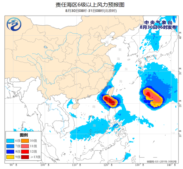
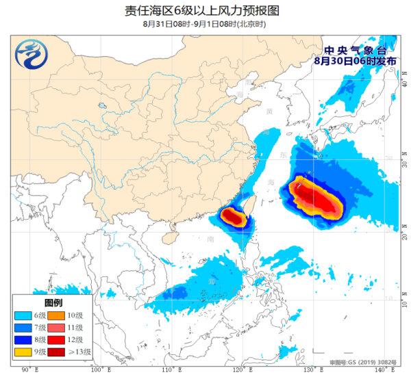
From the night of September 31st to the night of September 1st, due to the influence of Typhoon "Haikui", there will be strong winds of magnitude 7-9 and gusts of magnitude 10-11 in the southeastern waters of the East China Sea, with some areas experiencing winds of magnitude 10-12 and gusts of magnitude 13-14. For detailed information about Typhoon "Haikui", please refer to the latest issue of the Typhoon Bulletin of the Central Meteorological Observatory.
3、 Specific forecast for the next three days
The Central Meteorological Observatory issued a yellow typhoon warning at 06:00 on August 30th:
The center of Typhoon Sula, the 9th typhoon of this year, was located at 5 o'clock this morning on the sea surface approximately 220 kilometers southeast of Eluanbi, Taiwan Province, at 20.0 degrees north latitude and 121.5 degrees east longitude. The maximum wind force near the center was above 17, and the minimum pressure at the center was 915 hPa. The radius of the Category 7 wind circle was 220-250 kilometers, the Category 10 wind circle was 130 kilometers, and the Category 12 wind circle was 70 kilometers.
It is expected that "Sula" will move northwest at a speed of about 10 kilometers per hour and enter the northeast sea surface of the South China Sea on the night of the 30th or early morning of the 31st, gradually approaching the coastal areas of southern Fujian to eastern Guangdong. Its intensity will slowly weaken, and it is possible to land on the aforementioned coastal areas during the day of September 1st, or it may move towards the southwest direction in the coastal waters of eastern Guangdong.
Gale forecast: From 08:00 on August 30th to 08:00 on August 31st, there will be strong winds of 6-8 levels and gusts of 9-10 levels in the Bashi Strait, Taiwan Strait, the waters east of Taiwan, the northeast of the South China Sea, the coast of Fujian, and the coast of Taiwan Island. Among them, the winds in the eastern waters of the Bashi Strait and the northeast of the South China Sea are 9-11 levels, and some waters can reach 12-13 levels. The winds in the waters near the "Sula" center are 14-17 levels and gusts of 17 levels or above. Please pay attention to navigation safety for passing ships.
Precipitation forecast: From 08:00 on August 30 to 08:00 on August 31, there will be heavy to rainstorm in some areas of central and southern Taiwan Island, and local heavy rainstorm.
Defense Guidelines:
1. The government and relevant departments shall carry out emergency work for typhoon prevention and rescue in accordance with their responsibilities.
2. Water operations in relevant waters and passing ships should return to the port for shelter, strengthen port facilities, and prevent ships from anchoring, grounding, and collision.
3. Stop large-scale indoor and outdoor gatherings, as well as outdoor dangerous operations at heights.
4. Reinforce or dismantle structures that are easily moved by the wind. Personnel should not go out freely and should stay in windproof and safe places as much as possible, ensuring that the elderly and children stay in the safest place at home. Dangerous buildings should be evacuated in a timely manner. When the center of a typhoon passes by, the wind may decrease or remain stationary for a period of time. Remember that strong winds will suddenly hit, and you should continue to stay in a safe place to avoid the wind.
5. Relevant regions should pay attention to preventing mountain floods and geological disasters that may be caused by heavy rainfall.


