Will "Kanu" closely follow "Du Suri" and head straight towards East China? Experts have just provided analysis, Typhoon Relay Kanu | Zhejiang | Direct Attack
Typhoons one after another, "Dussuri" has just made landfall, and Zhejiang needs to raise its vigilance for Typhoon No. 6, "Kanu". Because it may target Zhejiang.
On the morning of July 28th at 11 o'clock, the Zhejiang Provincial Meteorological Observatory organized a concentrated interview on the relevant situation of Typhoon "Du Suri".
Zhou Lingli, the chief forecaster of the Zhejiang Provincial Meteorological Observatory, told Chao News reporters that the impact of "Du Suri" was basically over on July 30th. It is expected that "Kanu" will affect the east coast of China from July 31, and Zhejiang will face strong storm rain from August 1-3.
Today and Ming, Zhejiang is experiencing heavy rain and rain
Zhou Lingli introduced that Typhoon "Dussuri" has made landfall and its main impact on Zhejiang is rain.
Today, there are heavy to rainstorm in Wenzhou, Taizhou, the east and south of Lishui, and the south of Ningbo, some heavy rainstorm, and local extremely heavy rainstorm;
There will be moderate to heavy rain in western Zhejiang and coastal areas tomorrow, partial rainstorm and partial heavy rainstorm.
At present, rainstorm red warning has been issued in many places, so we must pay attention to prevent secondary disasters caused by heavy rainfall.
According to statistics, from 20:00 on July 25th to 8:00 on July 28th, the province's surface rainfall was 60 millimeters, with Wenzhou receiving 172 millimeters of rainfall and Taizhou receiving 128 millimeters of rainfall.
Kanu sets his sights on Zhejiang
The typhoon Kanu cannot be taken lightly.
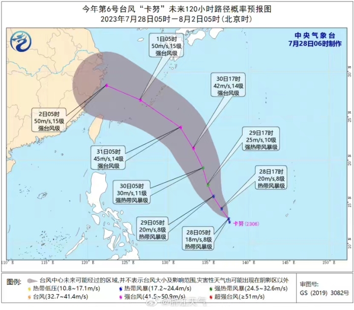
Typhoon Kanu, the 6th typhoon of this year, formed in the early morning of July 28th in the ocean east of the Philippines. It is expected that Kanu will move northwestward and turn northwest at a speed of about 15 kilometers per hour, gradually strengthening its strength and approaching the eastern coast of China.
The name "Kanu" comes from the Thai Meteorological Department, which means the tropical fruit jackfruit.
According to Xin Xin, a meteorological analyst at China Meteorological Channel, Typhoon "Kanu" will head straight towards East China in the next five days and is expected to make landfall in Zhejiang and Shanghai in early August, with a path very similar to that of "Kanu I" in 2005.
The Hangzhou Meteorological Observatory said that currently, major numerical forecasts predict that Typhoon "Kanu" will approach the waters near East China from the end of July to early August and may make landfall in Zhejiang.
"At present, Kanu is moving rapidly and is approaching the eastern coast of China. We will strengthen monitoring in the future," said Zhou Lingli.
According to this forecast path, Zhejiang will face severe pressure to prevent typhoons in the future.


