Why will "Du Suri" continue to bring extreme heavy rainfall to the Beijing Tianjin Hebei region after it stops numbering? North China | Circulation | Beijing Tianjin Hebei
According to the latest news from the Central Meteorological Observatory on July 29th, "Du Suri" weakened to a tropical depression in Susong County, Anqing City, Anhui Province at 8:00 am this morning. Due to further weakening of its wind power, it is difficult to determine its circulation center. The Central Meteorological Observatory stopped numbering it at 11:00 am.
Although the numbering was stopped, the influence of "Du Suri" did not end with it.
"Du Suri" stops numbering and continues northward
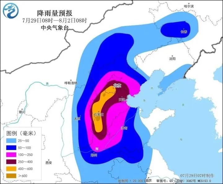
Beijing Tianjin Hebei or rainstorm center

According to the prediction in the picture, extreme heavy rainfall will continue to affect the Beijing Tianjin Hebei Shandong Henan Jin region as the residual circulation of the "Dussuri" continues to move northward.
It is expected that from July 29 to August 1, there will be continuous rainfall processes in North China, Huang Huai River and other places, including Beijing, Tianjin, Hebei, western Shandong, northern Henan, eastern Shanxi and other places. There will be heavy rainstorm in some areas, and local extremely heavy rainstorm, especially in parts of Beijing, Tianjin and Hebei, will be stronger.
Earlier on the 29th, the Central Meteorological Administration issued an important weather warning: the extreme nature of this heavy rainfall process is high, and the risk of causing disasters is high. It is expected that the cumulative rainfall will be over 100 millimeters, with a rainfall area of 220000 square kilometers, affecting a population of 130 million people. Some small and medium-sized rivers in southern Beijing, central and western Hebei, eastern Shanxi, and northern Henan have meteorological risks of exceeding the warning or guaranteed water level; The meteorological risk of flash floods and geological disasters occurring along the Taihang Mountains in southwestern Beijing, western Hebei, eastern Shanxi, and other mountainous areas is high in Shijiazhuang, Xingtai, and Baoding of Hebei. At the same time, there is a high risk of urban waterlogging and farmland waterlogging in Beijing, Tianjin, central and southern Hebei, and northern Henan.
The General Administration of Flood Control of China has decided to upgrade the level four emergency response for flood control in Beijing, Tianjin, Hebei, Shanxi, Shandong, and Henan to level three at 12:00 on July 29th. The China Meteorological Administration launched a Level 1 emergency response for major meteorological disasters on July 29th.
Why can "Du Suri" still travel a long distance after landing
Triggering extreme heavy rainfall over a thousand kilometers away?
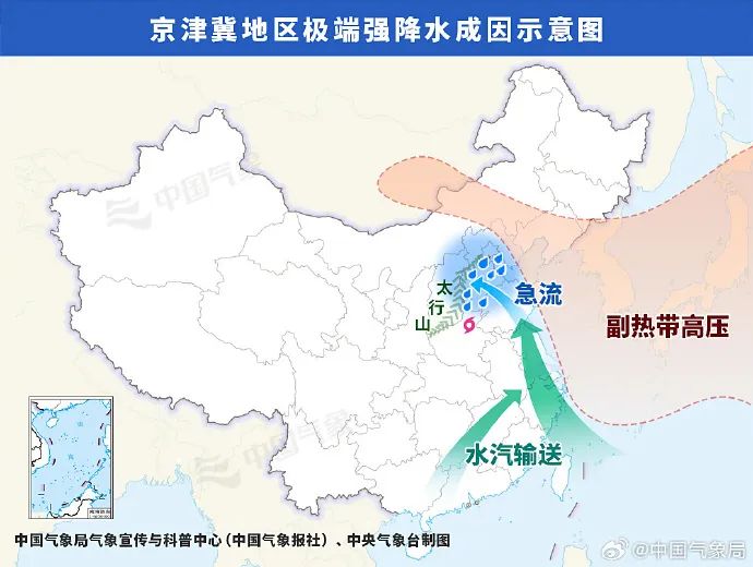
A schematic diagram of the causes of extreme heavy rainfall in the Beijing Tianjin Hebei region. Why would a typhoon with stopped numbering have such a significant impact on the North China and Huanghuai regions? On July 29th, the China Meteorological Administration held a strong rainfall ventilation meeting in North China and provided an explanation.
In fact, the direction of typhoon movement is not arbitrary, and the most important influencing factor is the well-known subtropical high pressure.

The chief forecaster of the Central Weather Observatory, Fang Chong, stated that the residual circulation of "Du Suri" is expected to enter Henan tonight. Due to the fact that the Beijing Tianjin Hebei region is located on the north and northeast sides of this circulation, and there is a subtropical high pressure in the eastern part of North China, and a high pressure ridge in the western part is also moving eastward, the high pressure on both sides is expected to open tonight, forming a high pressure dam in the northern part of North China. This will slow down the speed of the "Du Suri" circulation continuing northward, and the duration will increase from North China to the Huanghuai region, which will increase the accumulated rainfall.
On the other hand, due to the fact that "Dusurai" itself carries a large amount of water vapor, while the subtropical high is on the east side, there is a strong pressure gradient between the two, which will lead to the significant increase of easterly and southeasterly winds in the Beijing Tianjin Hebei region. At this time, there is a typhoon "Kanu" in the western Pacific Ocean, and the strong southeast wind will continuously transport the water vapor near the distant "Kanu" to the North China Plain. In addition, the easterly and southeast winds carrying water vapor are obstructed by the Taihang Mountains in the west of Beijing Tianjin Hebei, and will also concentrate in front of the mountains.
Fang Chong summarized that the long-term and abundant water vapor transport, combined with the increase in terrain, has caused extreme precipitation in the Beijing Tianjin Hebei region. It is expected that the precipitation will be very large, with some areas of the Beijing Tianjin Hebei region accumulating precipitation of 200 to 450 millimeters, and locally reaching over 650 millimeters.
On July 28th, workers straightened a fallen roadside tree on a section of G228 National Road located in Longhai District, Zhangzhou City, Fujian Province. Wang Xiurong, Chief of the Public Meteorological Service Center of the China Meteorological Administration, reminded that this rainfall process coincides with the weekend, and citizens in the affected areas should try to minimize going out to ensure home safety. Rainstorm weather may lead to power interruption or water immersion and other problems affecting residents' lives. Please do not easily touch wires, open flames, etc. If there is an outdoor power failure, you should timely shut down the electrical appliances at home. When power failure occurs, you should keep calm and contact the power company as soon as possible.
In addition, it is the peak season for summer tourism, and the areas affected by this round of rainfall are high-risk areas for tourism. In the near future, it is necessary to reduce outdoor activities in these areas or visit places that involve mountains and water.


