Why come so late? Are you preparing for a "magnifying move"? Authoritative interpretation by meteorological experts: Typhoon "Taili", the first subtropical typhoon that may make landfall in China this year | Typhoon | China
The Central Meteorological Administration issued a blue typhoon warning at 10:00 on July 15th, and the China Meteorological Administration launched a Level 4 emergency response for typhoons at 11:00. The South China Sea tropical depression has strengthened to become the fourth typhoon of the year, Typhoon Taili, this morning. According to the latest forecast from the Central Meteorological Observatory, Typhoon Taili is expected to rapidly strengthen in the future. It is expected to make landfall along the coast from the eastern part of Hainan Island to the western part of Guangdong from the night of the 17th to the morning of the 18th, and may become the first typhoon to make landfall in China this year.
Will Typhoon Tali, who has been "late" for a long time, be secretly gathering strength to prepare for "amplification tactics"? Is there really a tendency in recent years for the "initial Taiwan" to be relatively late? What are the changing trends in the overall impact of typhoons on China? Nie Gaozhen, a senior engineer at the Typhoon and Marine Meteorological Forecasting Center of the China Meteorological Administration, provided a detailed interpretation of the "initial typhoon" and related issues.
How long has Typhoon "Tai Li" slowed down the "initial Taiwan progress bar"?
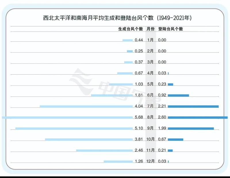
According to the forecast from the Central Weather Bureau, Typhoon Tai Li, the fourth typhoon of this year, is expected to make landfall along the coast from the eastern part of Hainan Island to the western part of Guangdong Province from the night of July 17th to the morning of July 18th. This landfall time is more than 20 days later than the average "first typhoon" landfall date of June 27th from 1991 to 2020.
The number of typhoons generated in the Northwest Pacific and South China Sea from January to June each year
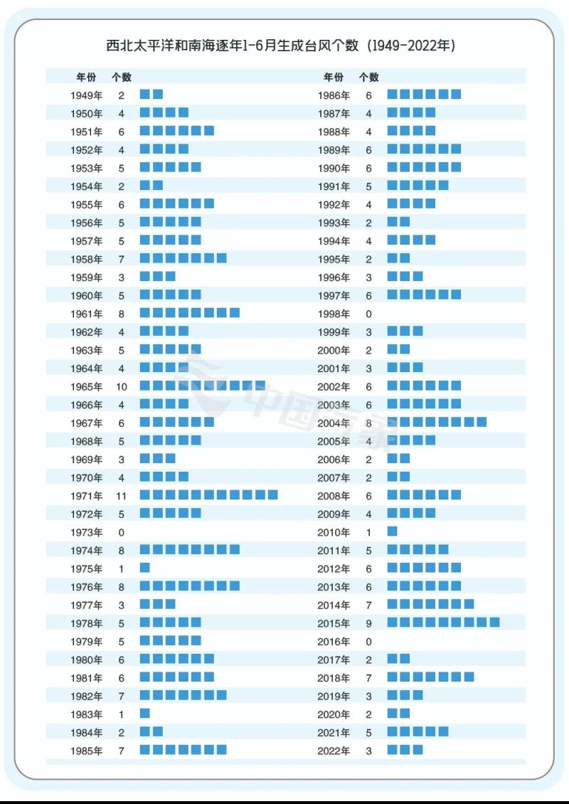
In order to clarify the fact that the typhoon was late, let's take a look at the degree of delay of Typhoon "Taili": dividing the date of the first typhoon landing in China since 1991 to 2020 into four time periods, Typhoon "Taili" is in the last 25%. This can also be seen as 75% of the years, the "first Taiwan" time is earlier than this year. The late arrival of Typhoon Tali is somewhat significant.
Do typhoons tend to make landfall later in recent years?
Based on the estimated landfall time of Typhoon Tai in the past two years and this year, the expected landfall date of Typhoon Tai Li in 2023 is from the night of July 17th to the morning of July 18th; The landing date of Typhoon "Siameba" in 2022 is July 2nd; The landing date of Typhoon "Chapaka" in 2021 is July 20th. The intuitive feeling is that compared to the average landing date of June 26th from 1991 to 2020, it is indeed a bit late.
But if this group of consecutive three-year lateness is placed in a longer time series, it will be found that there is no clear linear pattern. In the past three years, has "Chutai" been consistently "late"? The fact is, earlier on, there were also many instances of "Chutai" actively participating in attendance for consecutive years. It's too early to draw a conclusion now.
From the perspective of the overall impact of the typhoon season on China, have there been any significant changes in recent years?
Analyzing the destructive power of typhoons that have made landfall or affected China in recent years, it can be found that if there were a typhoon with particularly strong intensity that year, its impact would likely account for more than half of the overall impact of the typhoon season that year.
Generally speaking, particularly strong typhoons can bring strong precipitation, which may lead to geological disasters. Or if the wind is particularly strong, it will also cause significant losses to the cities along the way.
From this perspective, the public feels that the overall impact of typhoon seasons in recent years seems to be changing, possibly partly due to the absence of particularly strong typhoons that year. On the other hand, timely and accurate forecasts, proactive and favorable disaster prevention responses, as well as the absence of strong winds and heavy rainfall caused by typhoons in disaster prone areas, are all important reasons.
But the impact brought by typhoons is a double-edged sword. Many typhoons with relatively weak intensity are also silently doing some "good things", such as the affectionate names "sprinkler trucks" and "air conditioning", which are expectations and likes for their functions of relieving drought and cooling down.
How is the generation and landfall of typhoons this year?
Before the formation of Typhoon Tali, a total of three typhoons were generated in the western Pacific, with an average number of 5.2 over the years. With the addition of Typhoon No. 4, the overall number of typhoons generated was one less. If Typhoon Tai Li finally makes landfall in China, as of its expected date, the average number of typhoons that have made landfall in China over the years is 1.4, which is 0.5 less than this year.
Overall, the progress bar is slow but not very significant.
What is the cause of the formation of Typhoon Tali?
Firstly, the time is long enough. From the generation of Typhoon No. 3 this year to now, there has been a typhoon "window period" in the Northwest Pacific for over a month. From a climate perspective, the energy has already accumulated.
Secondly, the northward movement of the subtropical high pressure leaves room for the development of typhoon activity. Last week, the subtropical high pressure was very strong and covered the mid to low latitude ocean where typhoons were generated. Under the suppression of the strong subtropical high pressure, typhoon activity in the northwest Pacific has been suppressed. But the situation has changed in the past two days, as the subtropical high pressure has moved northward, providing growth space for the typhoon. As long as the external conditions that suppress the development of typhoons are eliminated, tropical disturbances may develop into tropical depressions.
Can typhoons bring relief to the high temperatures in southern China?
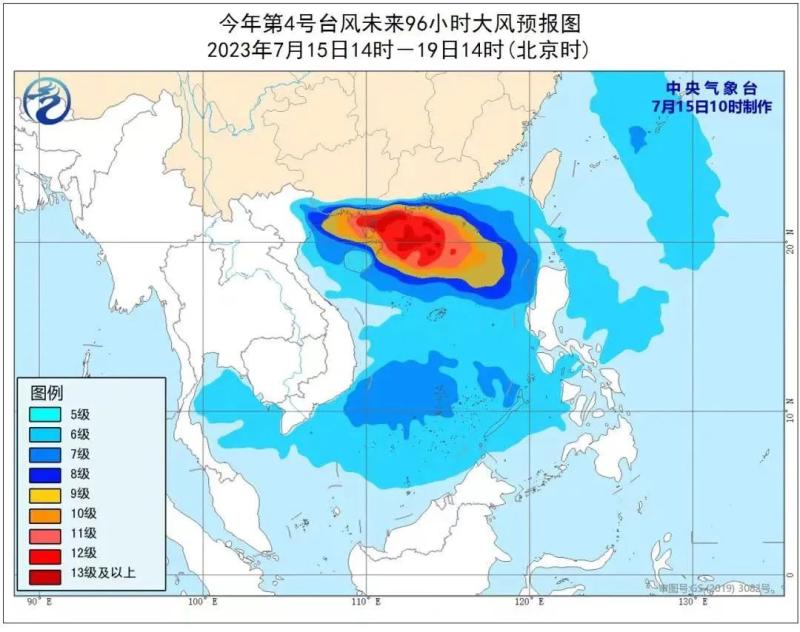
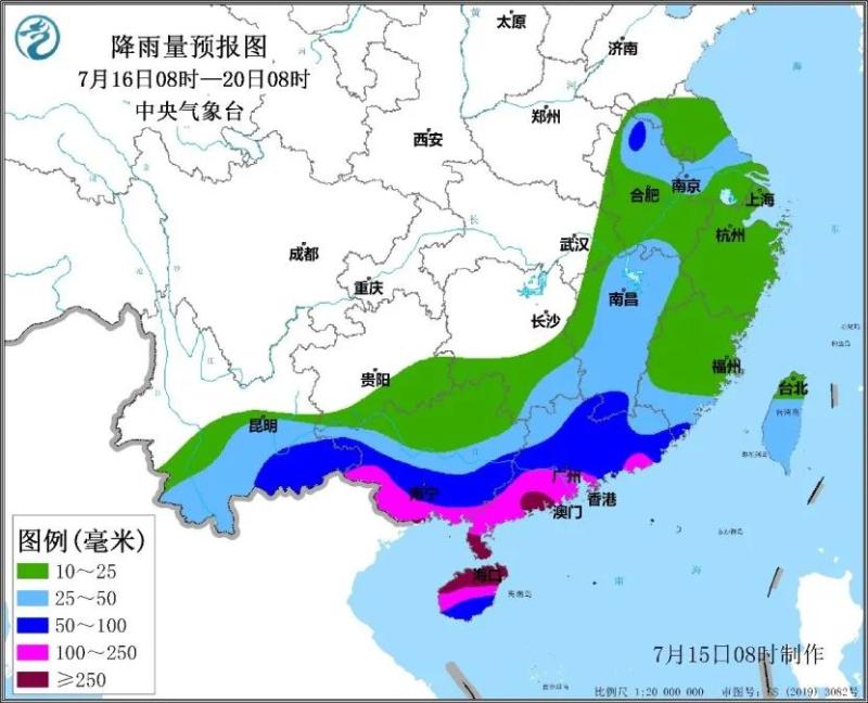
According to the forecast from the Central Weather Bureau, Typhoon "Taili" will move in a northwest direction at a speed of 10 to 15 kilometers per hour and make landfall along the coast from the eastern part of Hainan Island to the western part of Guangdong Province from the night of the 17th to the morning of the 18th. It is expected to make landfall at typhoon level or strong typhoon level.
It is expected that from the 16th to the 19th, due to the influence of typhoons and peripheral circulation, the cumulative rainfall in southern Guangdong, Hainan Island, southern Guangxi and other areas will be over 100 millimeters, with local areas reaching 250 to 450 millimeters. The strongest rainfall period is from the 17th to the 18th. During the rainfall period, there are strong convective weather such as lightning, short-term heavy rainfall, and local thunderstorms and strong winds. Starting from tomorrow, the high temperatures in the south will significantly weaken under the influence of typhoons.
Although Typhoon Tai Li can bring coolness, due to its strong intensity during landfall, there is a high risk of disaster. It is recommended that Guangdong, Hainan, and Guangxi make preparations for typhoon defense in advance, strengthen the prevention of strong wind disasters, urban and rural waterlogging, mountain floods, and geological disasters, and do a good job of harvesting and sun drying early rice. During the peak summer tourism season, it is recommended to do a good job in safety management for island and sea related tourism projects in the coastal areas of South China. Ships sailing in the relevant waters of the South China Sea should pay attention to avoiding areas affected by typhoons in advance, and offshore operators should evacuate in a timely manner.
Will Typhoon Tali rapidly strengthen near the shore?
After Typhoon Tai Li, the fourth typhoon of this year, entered the South China Sea, several internal and external conditions contributed to its strength development.
One is the warm sea temperature. Compared to the Western Pacific, the South China Sea has shallower waters and relatively higher sea surface temperatures, around 30 to 31 ℃, which is conducive to the strengthening of Typhoon No. 4. Secondly, the wind shear is not particularly strong and is more suitable. Thirdly, as the typhoon approaches the land, the conditions for high-altitude divergence will also improve. Fourthly, Typhoon Tali belongs to the category of small typhoons, and compared to large typhoons, the intensity of small typhoons is more likely to rapidly increase. At present, from the shape of the typhoon, the center of the typhoon appears as a flattened strip with relatively loose convection around it.
In the future, if the center of a typhoon can contract and become circular, convection will become more dense and symmetrical, and the intensity of the typhoon will be greatly strengthened.


