What is it for?, Controversial Zhengzhou Jinshui River Improvement: Brick Laying and Upgrading Along the River | Project | Brick Laying
Recently, the issue of "marble hanging on the river channel of Jinshui River in Zhengzhou, Henan Province" has attracted public attention.
According to local reports from media such as CCTV, the construction was actually carried out on the facade next to the pedestrian walkway along the river. According to official information such as the Environmental Impact Assessment Report of the Jinshui River Comprehensive Improvement Project, the urban section of the Jinshui River, such as Minggong Road Water Restaurant and Erqi Road People's Road, adopts a vertical retaining wall+riverbed walkway revetment form, which improves hydrophilicity by shortening the distance between the walkway and the water surface.
Jinshui River is one of the main flood discharge channels in the main urban area of Zhengzhou City, with a total length of about 28km, crossing the urban area of Zhengzhou from southwest to northeast.
On the 7th, a reporter from China Central Radio and Television Network started from Guojiazui Reservoir, the starting point of the Jinshui River, and walked northeast along the banks of the Jinshui River. They arrived at the northwest side of the intersection of Songshan South Road and Longhai West Road, as well as the north side of Zhengzhou People's Park and other locations along the Jinshui River. They found that some of the walls on both sides of the pedestrian walkway in the river had dry marble hanging. The length of the marble hung at each location is about 100 meters, and the height of the marble itself ranges from 1.6 to 2 meters.
According to the report, after on-site inspection, it was found that there was indeed a situation of laying marble around the Jinshui River, but it was not inside the river, but on the walls of the pedestrian walkway above the river.
On the 7th, a reporter from the New Beijing News arrived at the section from Dongming Road to Zhongzhou Avenue in Jinshui River and found that on one side of the road, which is about 80 centimeters higher than the riverbed, tiles are laid against a 1.6 meter high wall. Construction workers told reporters that each tile is 20 centimeters high, and 8 tiles are needed from the bottom to the top of the wall. "This is not the river mentioned online, but a pedestrian walkway." On the exterior of the wall that has already been tiled, about 50 centimeters above the ground, embedded landscape lights are also installed, connected to wires, and some walkways have guardrails installed on the outside.
In reports from two media outlets, some on-site construction workers questioned, "The river is not deep, less than 1 meter. A few days ago, it rained in Zhengzhou, and the water was on par with the pedestrian walkway. If it rained heavily, the river was full, so paving it was a pure waste." Another citizen who has been working near the Jinshui River for a long time introduced that there was already a pedestrian walkway by the Jinshui River, but now the height of the walkway has been dug down. A video taken by a construction worker shows that at around 18:00 on July 3rd, due to rainfall, the river water flooded the pedestrian walkway, and the water level was close to the position of embedded landscape lights.
Other netizens have raised concerns about safety when tiling along the river? Is the height difference between the pedestrian walkway along the river and the water surface too small?
Pengpai News has noticed that the above construction is part of the Jinshui River Comprehensive Improvement and Upgrading Project. The project starts from Guojiazui Reservoir and extends to Dongfeng Canal, with a total length of 22.3 kilometers for river treatment. It includes water safety assurance project, comprehensive improvement and upgrading project along the river, water quality assurance and ecological restoration project, bridge restoration and upgrading project, greening improvement project, smart management project, etc.
In 2020, the Zhengzhou Urban and Rural Development Bureau pointed out in its response to a proposal from a member of the Municipal Committee of the Chinese People's Political Consultative Conference that the current situation of the Jinshui River is mainly characterized by a "three sided light" river channel, which has problems such as flood control checkpoints, large fluctuations in water quality and quantity, insufficient ecological integrity, fragmentation of public spaces, and lack of supporting facilities. Overall, it has poor hydrophilicity and poor image quality.
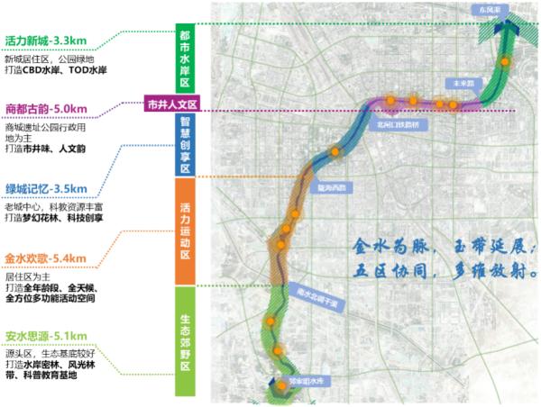
The comprehensive renovation and upgrading project plan for the Jinshui River, which was completed at that time, claimed to fully draw on the design concept of "segmented renovation and shoreline sorting" in Seoul, South Korea. It is divided into five areas from upstream to downstream: ecological suburban area, vitality sports area, smart creation and enjoyment area, urban cultural area, and urban waterfront area.
According to this plan, the section of the Jinshui River on the north side of Zhengzhou People's Park, as reported by China Central Radio and Television Network, belongs to the Shijing Cultural District among the five districts.
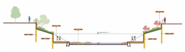
At that time, the Zhengzhou Urban and Rural Development Bureau introduced that in order to solve the problem of insufficient hydrophilicity of the river, the plan combined with site conditions to reduce the height difference between the greenway and the normal water level of the river, and added hydrophilic stairs and platforms in the renovated revetment. In the slow traffic system, water passing steps and cantilevered greenways were set up, and the dam was presented in forms such as dragon scale weirs. Interactive fountains, water curtains, etc. were set up in landscape sketches to enhance the hydrophilicity effect from multiple levels such as points, lines, and surfaces, achieving interdependence between the water city and people and water.
Specifically, it includes: demolishing walls for greenery, constructing new node parks, upgrading existing parks, connecting waterfront green spaces, and integrating blue-green spaces in river channels; Adopting the technique of "shoreline sorting and element utilization" for revetment renovation, utilizing cultural and technological elements, and utilizing the huge height difference between the embankment top road and the riverbed below to create a rich and diverse waterfront experience space, fully integrating various forms of water expression such as waterfalls, fountains, gushing springs, waterfalls, etc. according to local conditions; Choose revetment forms such as grassy slope water inlet+vertical retaining wall, two-level ecological block retaining wall, vertical high retaining wall, two-level low retaining wall+gentle slope to increase hydrophilicity; Demolish the original rubber dam and construct a new drop water dam in conjunction with the landscape nodes to enhance the landscape effect.
After the elevation of some hiking trails is lowered, the difference between the elevation and the normal water level is small, which poses a certain flood prevention risk. The Zhengzhou Urban and Rural Development Bureau has explained that in this upgrade and renovation, warning signs, reminder announcements, etc. should be set up at the entrance and exit of the waterfront hiking trail. At the same time, pedestrian flow control facilities should be set up at the entrance of the sunken hiking trail. During flood periods, pedestrians are prohibited from entering. Referring to the mature management experience of urban rivers such as Qingxi River in South Korea, emergency escape routes and barrier free facilities should be set up under the bridge and adjacent greenway sections to ensure pedestrian safety.
The overall functional zoning of the Jinshui River scheme. "Zhengzhou Release" picture of WeChat official account
According to the WeChat official account "Released in Zhengzhou", on November 25, 2021, Zhengzhou officially launched the comprehensive renovation of Jinshui River focusing on ensuring flood control safety.
Pengpai News has noticed that the plan announced this time will continue to be divided into five zones from upstream to downstream based on the characteristics of the site. The plan is based on the design principle of "river road park" integration, to achieve vertical walkway connectivity, horizontal integration of both sides, and to build a complete waterfront slow traffic system. For example, using various forms to ensure the full connectivity of the upstream and downstream slow traffic systems on both sides of the river; New pedestrian bridges, river crossing steps, etc. will be built to promote the organic integration of parks, roads, and rivers.
Typical section design. "Zhengzhou Release" picture of WeChat official account
In terms of flood control and drainage, the relevant person in charge of the Zhengzhou Urban and Rural Development Bureau stated that the flood discharge capacity will be improved through the use of checkpoints, along river beds, and bank slopes. For example, measures such as excavation, widening, and reconstruction under the river can be taken to enhance the flood discharge capacity of the Kakou section of the river; Sort out the entire slope of the river, optimize the design of the longitudinal section, and ensure smooth flood discharge; By optimizing the design of the entire river section and combining it with the "micro renovation" of the bank slope, the embankment system is improved and the flow capacity is enhanced. In combination with the reconstruction of the Guojiazui Reservoir in the upstream and the construction of the South Interception Gully, the flood control standard of the Jinshui River will be raised to a 100 year return period, ensuring the overall flood control safety of the Jinshui River Basin.
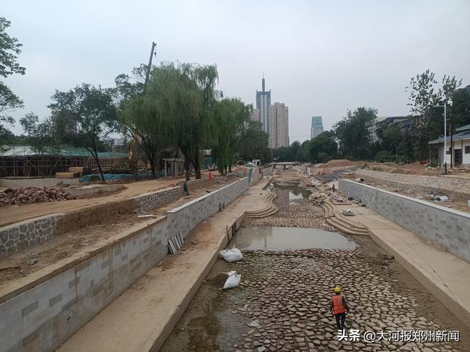
The renovation site of Jinshui River Riverside Park. Dahe Baotu
Later, in August 2022, Zhengzhou Urban and Rural Construction Bureau revealed in its reply to the relevant proposal that after the "July 20" extremely heavy rainstorm disaster in 2021, the comprehensive renovation project of Jinshui River was accelerated. The renovation plan gradually shifted from landscape improvement and rich business types to focusing on the improvement of basic functions such as flood control standards, water quality improvement, and slow traffic connection. The planning and design of the trinity flood control system of "upper storage, middle interception, and lower drainage" reached the flood control standard for a once-in-a-century return period, and the overall goal of "safe river, clear water, open roads, and beautiful banks" was achieved. The specific measures include: one is to accumulate. Dredging, dredging, and expanding the Guojiazui Reservoir upstream of the South Fourth Ring Road, reinforcing the dam body, and rebuilding the reservoir spillway. Second, "clear". More than 3500 water blocking miscellaneous trees have been cleared in the upstream 5-kilometer section of the third ring road in the west of the Jinshui River; The task of dredging the severely silted river section from South Fourth Ring Road to Hubin South Road at 10 locations; Ensure smooth drainage channels in the river during the flood season. Three "sparse". Implement engineering management for four sections of the Kakou River in the middle reaches of the Jinshui River, including Dihu Lake, Daxue North Road Bridge, Beizhaokou Yanhe Road, and Shuishang Restaurant, to overcome flood bottlenecks, excavate drainage channels, and enhance flood discharge capacity.
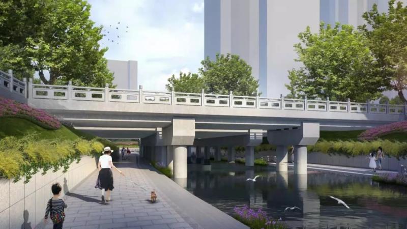
Rendering of the Jinshui River Comprehensive Improvement Project North University Road Bridge Project. Map of China Construction Seventh Bureau Transportation Company


