Various regions and departments strengthen typhoon prevention deployment and flood prevention | Typhoon | Department
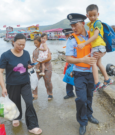
The picture shows on July 25th, before the arrival of Typhoon "Dussuri", police helped residents safely evacuate in the Zhongmen Village aquaculture area located in Pingtan Comprehensive Experimental Zone, Fujian Province.
Photo by Xie Guiming
Our newspaper, Beijing, July 26. This year's No. 5 typhoon "Du Suri" is about to move into the northeastern part of the South China Sea and will land on the coast of Fujian and Guangdong from the morning to the morning of the 28th. At 8 o'clock on the 26th, the China Meteorological Administration upgraded the typhoon emergency response to level 2. At 10 o'clock on the 26th, the Central Meteorological Observatory issued the first typhoon red warning this year. At 18: 00 on the 26th, the Central Meteorological Station continued to issue a red typhoon warning.
At 17:00 on the 26th, the center of "Du Su Rui" was located on the southern sea surface of the Bashi Strait, about 280 kilometers south of E Luan Bi in Taiwan Province, China. The maximum wind speed near the center was 16 levels. It is expected that "Du Suri" will move towards the northwest at a speed of 10-15 kilometers per hour, and will enter the northeast of the South China Sea from the night of the 26th to the morning of the 27th. Its intensity will increase, and it will gradually approach the coastal areas from Fuqing, Fujian to Huilai, Guangdong. It will make landfall in the above-mentioned coastal areas from the morning of the 28th to noon, with the maximum possibility of landfall in the coastal areas from Jinjiang, Fujian to the border between Fujian and Guangdong. At the time of landfall, it will be of strong typhoon level or super typhoon level, with wind speeds of 14-16. After landfall, the typhoon will turn northward and gradually weaken in intensity, but the circulation of the typhoon will maintain and move northward for a long time.
According to historical data analysis and prediction by the Central Meteorological Observatory, "Dussuri" has the characteristics of strong landing intensity, large wind and rain impact, and wide range. It is expected that from the 26th to the 29th, there will be wind speeds of 6-8 levels and gusts of 9-10 levels in the ocean east of Taiwan, the eastern and southern parts of the South China Sea, the Bashi Strait, the Taiwan Strait, Taiwan Island and its coastal areas, the central and southern coasts of Fujian, and the eastern coast of Guangdong. The wind speeds of 9-12 levels and gusts of 13-15 levels in the southern coastal areas of Fujian, the Bashi Strait, the northeastern part of the South China Sea, and the southern waters of the Taiwan Strait will also be affected. The wind speeds in the nearby waters where the typhoon center passes can reach 13-17 levels and gusts of 17 levels or above. Heavy to rainstorm will successively occur in parts of Taiwan Island, eastern Zhejiang, Fujian, eastern Guangdong and coastal areas, Jiangxi, Anhui, Huang Huai River, North China and other places, and heavy rainstorm will occur in parts of eastern and southern Taiwan Island, central and southern Fujian and eastern coastal areas, eastern Zhejiang coastal areas, eastern Guangdong and other places, with local extremely heavy rainstorm.
The reporter learned from the Ministry of Water Resources that under the influence of "Du Suri", some areas in the east of the the Pearl River basin, the the Taihu Lake Lake basin, the middle and lower reaches of the Yangtze River basin, the middle and lower reaches of the Huaihe River basin and other places will have heavy rain from south to north successively, and some areas will have heavy rainstorm. It is expected that the river flow in the rainstorm area will rise.
The Ministry of Water Resources arranged and deployed the "Dusurai" rainstorm and flood prevention work in a rolling manner, and sent four working groups to Fujian, Guangdong, Zhejiang, Jiangxi and other provinces to assist in the typhoon rainstorm and flood prevention work. At 10:00 on the 26th, the Pearl River Flood Control Headquarters upgraded the level IV emergency response for flood and typhoon prevention to level III. The Pearl River Water Resources Commission upgraded the level IV emergency response of flood prevention to level III.
On the 26th, the National Flood Control Administration upgraded the emergency response for flood and typhoon prevention to level III and dispatched four working groups to Zhejiang, Fujian, Guangdong, and Jiangxi to assist in guiding flood and typhoon prevention work. The Emergency Management Department has optimized and adjusted emergency forces such as engineering rescue, aviation rescue, and drainage, coordinating and implementing over 4000 people and 5 helicopters to be ready for reinforcement at any time. On that day, the General Office of Flood Control and the Ministry of Emergency Management organized a special video conference on flood control and typhoon prevention, and held discussions with the China Meteorological Administration, the Ministry of Water Resources, and the Ministry of Natural Resources to assess the development trend of "Du Suri". The video was connected to the flood control and typhoon prevention offices of provinces such as Fujian, Guangdong, Zhejiang, and Sichuan, and deployed flood control and typhoon prevention work in key areas.
According to consultation and analysis, "Du Suri" may affect provinces such as Fujian, Guangdong, Zhejiang, Jiangxi, Anhui, Shandong, Henan, Hebei, Tianjin, and Beijing. The meeting emphasized that all regions and departments should adopt the highest standards and strictest requirements, take sufficient and detailed defense measures, highlight the work of ships returning to port for shelter, personnel going ashore for refuge, and the relocation and resettlement of people in dangerous areas. We should comprehensively implement defense measures for weak links such as floods in small and medium-sized rivers, floods in small and medium-sized reservoirs, mountain floods and geological disasters, urban waterlogging, etc., close coastal tourist attractions in advance, and strengthen safety inspections of important facilities such as coastal petroleum, chemical, nuclear power, railways, airports, mining enterprises, and lifeline projects such as electricity, communication, and water supply.
Multiple departments in Fujian Province are coordinating and deploying preventive measures. At 11:00 on the 26th, the Fujian Provincial Meteorological Observatory upgraded the "typhoon warning" to level II; At 12:00 on the 26th, Fujian Province's typhoon prevention index raised the emergency response level to level II; The Fujian Provincial Flood Control Office requires all regions and departments to closely monitor the trend of typhoons; The Fujian Provincial Maritime Safety Administration launched a Level II typhoon prevention response at 10:00 on the 26th.
At 16:00 on the 26th, the Guangdong Provincial Flood and Drought Control Headquarters upgraded the level III emergency response to level II emergency response. Guangzhou Railway Group has arranged for the suspension or adjustment of some high-speed trains on the Hangzhou Shenzhen and Meishan lines.
According to the Emergency Management Department of Zhejiang Province, at 12:00 on the 26th, the Zhejiang Provincial Flood Control Index adjusted the emergency response for typhoon prevention at sea to a level IV emergency response for typhoon prevention, requiring all departments in Zhejiang Province to closely monitor typhoon movements and do a good job in defense.


