Typhoon red warning continues to be raised high
The Central Meteorological Observatory continued to issue a typhoon red warning at 18:00 on September 1st:
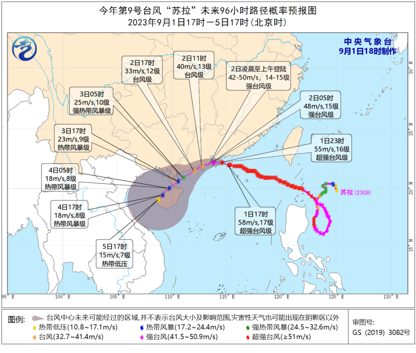
The center of Typhoon Sura, the 9th typhoon of this year, was located at 5 pm this afternoon on the northeast sea surface of the South China Sea, approximately 110 kilometers southeast of Hong Kong. It is located at 22.0 degrees north latitude and 115.1 degrees east longitude. The maximum wind force near the center is 17, and the minimum pressure at the center is 925 hPa. The radius of the Category 7 wind circle is 250-280 kilometers, the Category 10 wind circle is 130 kilometers, and the Category 12 wind circle is 70 kilometers.
It is expected that "Sula" will move at a speed of 10-15 kilometers per hour towards the northwest and gradually weaken in intensity. It will make landfall or pass through the coastal areas of Taishan, Guangdong to Shenzhen from the early morning of September 2, and then move towards the southwest.
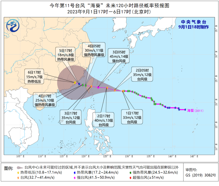
In addition, the center of Typhoon "Haikui", the 11th typhoon of this year, was located at 5 pm this afternoon on the northwest Pacific Ocean, about 770 kilometers southeast of Taipei City, Taiwan Province. It is 22.4 degrees north latitude and 128.5 degrees east longitude. The maximum wind force near the center is 12, and the minimum pressure at the center is 975 hPa. The radius of the seventh level wind circle is 150-200 kilometers, the radius of the tenth level wind circle is 70-120 kilometers, and the radius of the twelfth level wind circle is 30 kilometers.
It is expected that the "sea anemone" will move towards the west at a speed of 15-20 kilometers per hour, gradually increasing in intensity and reaching a strong typhoon level. It will make landfall along the eastern coast of Taiwan around the evening of the 3rd, then pass through Taiwan and gradually approach the coast of Fujian.
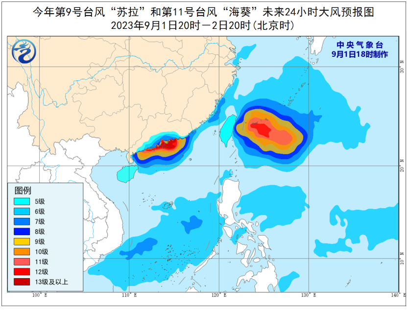
Gale forecast: from 20:00 on September 1 to 20:00 on September 2, under the influence of "Sura", there will be 6-7 gales and 8-9 gusts in the Taiwan Strait, the central and southern parts of the South China Sea, the the Nansha Islands, the the Zhongsha Islands, the sea area near Huangyan Island, and the Zhejiang coast; The northwest of the South China Sea, the coast of Fujian, the coast of Guangdong, the mouth of the the Pearl River, Hong Kong and Macao will have gales of magnitude 7-9 and gusts of magnitude 10-11. Some of the above sea areas or regions will have gales of magnitude 10-12. The wind force near the sea or region where the "Sula" center passes will be of magnitude 13-17 and gusts of magnitude 17 or above; Affected by the "sea anemone", there are 6-7 levels in the southern and eastern parts of the East China Sea, and 8-10 levels in some waters, with gusts of 11-12 levels of strong winds.
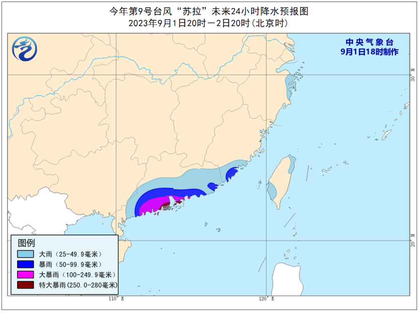
Precipitation forecast: from 20:00 on September 1 to 20:00 on September 2, affected by "Sura", there will be heavy to rainstorm in southeast Fujian, central and southern Guangdong, Hong Kong, Macao and other places, among which, there will be heavy rainstorm in parts of southern Guangdong, Hong Kong, Macao and other places, and local extremely heavy rainstorm
Defense Guidelines:
1. The government and relevant departments shall carry out emergency work for typhoon prevention and rescue in accordance with their responsibilities.
2. Water operations in relevant waters and passing ships should return to the port for shelter, strengthen port facilities, and prevent ships from anchoring, grounding, and collision.
3. Stop large-scale indoor and outdoor gatherings, as well as outdoor dangerous operations at heights.
4. Reinforce or dismantle structures that are easily moved by the wind. Personnel should not go out freely and should stay in windproof and safe places as much as possible, ensuring that the elderly and children stay in the safest place at home. Dangerous buildings should be evacuated in a timely manner. When the center of a typhoon passes by, the wind may decrease or remain stationary for a period of time. Remember that strong winds will suddenly hit, and you should continue to stay in a safe place to avoid the wind.
5. Relevant regions should pay attention to preventing mountain floods and geological disasters that may be caused by heavy rainfall.


