There may be a extremely heavy rainstorm in the southeast coastal area of Zhejiang Province, and another "three stops and one rest", red alert! "Du Suri" approaches the center of Fujian and Guangdong at over 10 kilometers per hour | Typhoon | One Rest
The Central Meteorological Observatory continued to issue a typhoon red warning at 06:00 on July 27th:
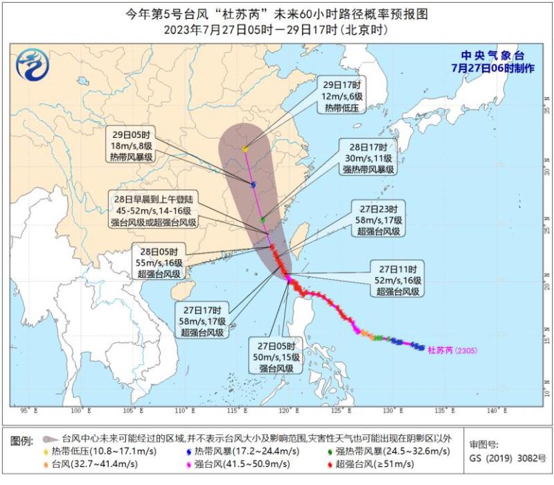
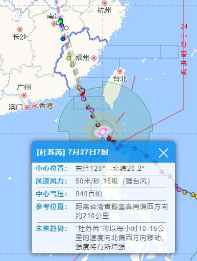
The center of Typhoon Du Suri, the 5th typhoon of this year, was located at 5 o'clock this morning on the sea surface about 220 kilometers southwest of E Luan Bi in Taiwan Province, China. It is 20.1 degrees north latitude and 120.0 degrees east longitude. The maximum wind force near the center is 15 levels, with a minimum pressure of 940 hPa at the center. The semi diameter of the 7th level wind circle is 300-450 kilometers, the radius of the 10th level wind circle is 120-160 kilometers, and the radius of the 12th level wind circle is 90-100 kilometers.
It is expected that "Du Suri" will move towards the northwest direction at a speed of 10-15 kilometers per hour, with increased intensity, and gradually approach the coastal areas from Fuqing, Fujian to Huilai, Guangdong. It will land on the above-mentioned coastal areas from the morning to the morning of the 28th, with the maximum possibility of landing on the coastal areas from Jinjiang, Fujian to the border between Fujian and Guangdong.
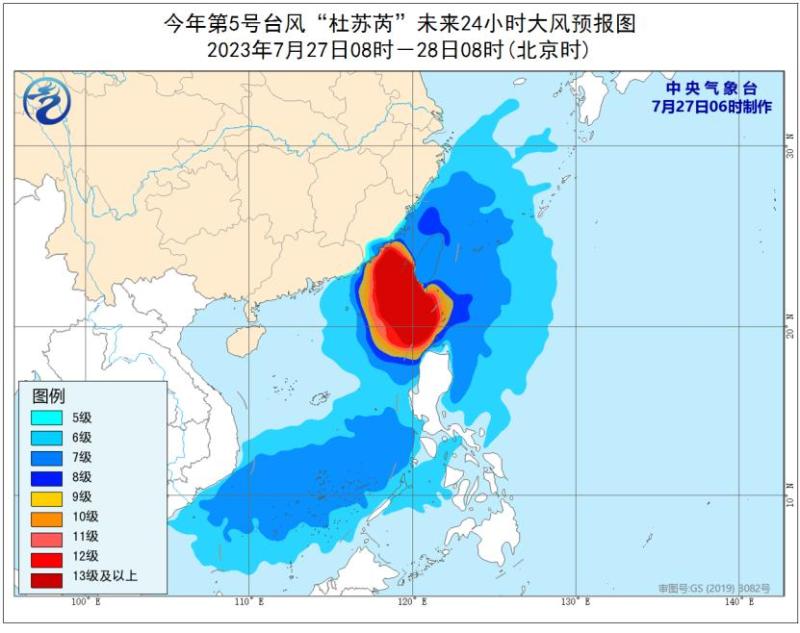
Gale forecast: From 08:00 on the 27th to 08:00 on the 28th, there will be strong winds of force 6-8 and gusts of force 9-10 in the Bashi Strait, eastern and southern waters of the South China Sea, eastern waters of Taiwan, Taiwan Strait, most of the East China Sea, as well as Taiwan Island and its coastal areas, Fujian coastal areas, Zhejiang coastal areas, and eastern Guangdong coastal areas. Among them, the Bashi Strait, northeastern and southeastern waters of the South China Sea, southern waters of the Taiwan Strait, some coastal areas of southern Fujian, and southern coastal areas of Taiwan Island will have winds of force 9-12 and gusts of force 13-15. The nearby waters passing through the "Dusui" center will have winds of force 13-17 and gusts of force 17 or above.
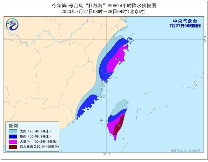
Precipitation forecast: From 08:00 on the 27th to 08:00 on the 28th, there will be heavy rain to rainstorm in Taiwan Island, eastern Fujian, eastern Zhejiang, etc., of which, heavy rainstorm will be seen in some areas in eastern Taiwan Island, coastal areas in eastern Zhejiang, etc., and extremely heavy rainstorm will be seen in the southeastern part of Taiwan Island.
Defense Guidelines:
1. The government and relevant departments shall carry out emergency work for typhoon prevention and rescue in accordance with their responsibilities.
2. Water operations in relevant waters and passing ships should return to the port for shelter, strengthen port facilities, and prevent ships from anchoring, grounding, and collision.
3. Stop large-scale indoor and outdoor gatherings, as well as outdoor dangerous operations at heights.
4. Reinforce or dismantle structures that are easily moved by the wind. Personnel should not go out freely and should stay in windproof and safe places as much as possible, ensuring that the elderly and children stay in the safest place at home. Dangerous buildings should be evacuated in a timely manner. When the center of a typhoon passes by, the wind may decrease or remain stationary for a period of time. Remember that strong winds will suddenly hit, and you should continue to stay in a safe place to avoid the wind.
5. Relevant regions should pay attention to preventing mountain floods and geological disasters that may be caused by heavy rainfall.
At 10 o'clock today, Xiamen launched a Level 1 emergency response against typhoons
According to the typhoon warning report issued by the Municipal Meteorological Bureau and in accordance with the Xiamen Flood and Typhoon Prevention Emergency Plan, our city raised the typhoon prevention emergency response to level one at 10 o'clock.
Quanzhou City has launched a Level I emergency response to prevent typhoons, with "three stops and one rest" implemented from 18:00 today to 12:00 on the 29th
Emergency warning!
"Du Suri" is getting closer and closer!
Less than 550 kilometers away from Quanzhou
Quanzhou City's typhoon prevention index has launched a Level I emergency response to prevent typhoons!
All member units of the Municipal Defense Bureau:
The 5th typhoon of this year, "Dussuri", was located about 220 kilometers southeast of Eluanbi in Taiwan Province at 5 o'clock today, with a maximum wind force of 15 levels near the center. It is expected that "Du Suri" will move northwest at a speed of 10-15 kilometers per hour and make landfall along the southern coast of Fujian from the morning of the 28th to the morning.
The Municipal Meteorological Observatory has issued a typhoon warning of level I. According to the relevant provisions of the Quanzhou City Flood Control, Typhoon Prevention and Drought Relief Emergency Plan, the Municipal Flood Control Bureau has decided to increase the typhoon prevention emergency response to level I at 8:00 am on July 27th.
Please all member units of the city's typhoon prevention index and county's typhoon prevention index strictly follow the requirements of Level I emergency response for typhoon prevention, and make every effort to do a good job in typhoon prevention. The high-definition video system for flood prevention in cities, counties, and townships must be on standby 24/7 and manned by dedicated personnel until the response is lifted.
Quanzhou Municipal People's Government Flood Control and Drought Relief Headquarters
July 27, 2023
Quanzhou City Defense No. 5 Typhoon "Dussuri" Mobilization Order
All citizens:
According to forecasts from meteorological and oceanic departments, Typhoon Dussuri, the 5th typhoon of this year, is most likely to make landfall along the southern coast of our province from the early morning to the morning of July 28th. Our city will be directly hit by the typhoon. At 8:00 am this morning, the Municipal Flood Control and Drought Relief Command launched a Level I emergency response to prevent typhoons. After research and decision by the Municipal Flood Control and Drought Relief Command:
From 18:00 on July 27th to 12:00 on July 29th, the city will implement the "three stops and one rest" policy, which includes work stoppage, production stoppage, class suspension, and market closure.
1. All coastal ports, docks, ferries, tourist attractions, dangerous coasts, and beach resorts will be closed, and all construction sites related to the sea will be suspended.
2. All large-scale outdoor activities in the city will be suspended, and all types of schools, training institutions, summer camps, etc. will be closed.
3. All public transportation vehicles in the city will cease operation.
4. All entertainment venues, food stalls, farmhouses, outdoor catering and other business establishments shall cease operations.

5. All citizens and tourists should stay indoors as much as possible and not go out unless necessary. Prepare daily necessities such as food and drinking water.
6. Residents living in high-rise buildings should promptly transfer and reinforce high-altitude suspended objects and balcony displays to prevent falling objects from high altitude.
7. Each community's underground space and parking lot should be equipped with sufficient flood prevention materials such as water barriers and sandbags. Vehicles in low-lying underground parking lots should be parked on the ground as much as possible.
8. The gantry cranes at ports and docks, as well as the tower cranes at construction sites, should be lowered in advance and protective measures should be taken. All personnel living in dangerous areas such as sheds, prefabricated houses, simple housing, and dangerous old houses should be evacuated to safe accommodation.
9. Each emergency rescue and people's livelihood guarantee unit should take measures to prepare for disaster relief, including water supply, power supply, gas supply, transportation, communication, civil affairs, medical treatment, drug supply, and supply of main and auxiliary food. 399 designated fresh agricultural and sideline product suppliers in the city have started operating and supplying, ensuring that the supply of essential daily necessities for the public is not affected.
10. Public security and traffic police departments should increase their police force, maintain traffic order, and ensure traffic safety and smoothness.
11. Open up all disaster avoidance places for the public to take shelter, while ensuring the basic living standards of the people in need of disaster avoidance.
At present, the situation of typhoon prevention in our city is very serious. Please all citizens firmly follow the work deployment of the provincial party committee, provincial government, municipal party committee, municipal government and municipal defense index, always adhere to the principle of people first and life first, mobilize the whole people, act quickly and unite as one to fight against the typhoon rainstorm disaster, practically guarantee the safety of people's lives and property, and strive for the overall victory of typhoon prevention work!
Quanzhou Municipal People's Government Flood Control and Drought Relief Headquarters
July 27, 2023
The local area along the southeast coast of Zhejiang Province may have a extremely heavy rainstorm today
With the approaching of typhoon "Dussuri", the wind and rain along the coast of Zhejiang will gradually intensify today and tomorrow, with local or present extremely heavy rainstorm. In terms of temperature, under the influence of typhoon and typhoon, large-scale high temperatures in Zhejiang will disappear without a trace.
Although Typhoon Dussuri will not directly make landfall in Zhejiang, as it approaches step by step, the wind and rain along the Zhejiang coast have also become significant. Monitoring shows that from 12:00 to 15:00 on July 26th, Wenzhou, Taizhou, Zhoushan, Lishui and other places experienced short-term heavy rainfall and local thunderstorm winds, with a total of 36 stations experiencing thunderstorms of level 8 or above.
At 05:00 this morning, the center of Typhoon "Dussuri" was located on the sea surface about 220 kilometers southwest of Eluanbi in Taiwan Province, China. It is expected that "Dussuri" will move northwest at a speed of 10-15 kilometers per hour, and it is most likely to make landfall along the coast from Jinjiang, Fujian to the border of Fujian and Guangdong on the morning of the 28th.
According to the latest forecast issued by the Zhejiang Meteorological Observatory, today, due to the influence of the cloud system outside the typhoon, there are moderate to heavy rain in eastern Zhejiang, including heavy to rainstorm in Wenzhou, Taizhou, southern Ningbo, eastern Lishui, heavy rainstorm in some areas, and local extremely heavy rainstorm in southeast coastal areas; It is cloudy in other areas, sometimes there are showers or thunderstorms from afternoon to night, which can be accompanied by short-term rainstorm, strong thunder and lightning, and local thunderstorm gales of 8~10.
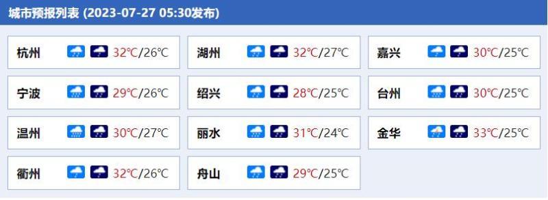
Forecast for cities in Zhejiang Province
Tomorrow, there will be moderate to heavy rain in southern Zhejiang and coastal areas, including heavy to rainstorm in Lishui, Wenzhou, Taizhou, and southern Ningbo, heavy rainstorm in some areas, and local extremely heavy rainstorm; Other areas are cloudy to cloudy with showers or thunderstorms, some areas have moderate to heavy rain, and some areas have rainstorm.
The day after tomorrow, there will be moderate to heavy rain in western Zhejiang and coastal areas, rainstorm in some areas, and local heavy rainstorm; Other areas are cloudy to cloudy with showers or thunderstorms, some areas have moderate to heavy rain, and some areas have rainstorm.
In addition, today and tomorrow, there will be gusts of 10-12 levels in the central and southern waters of the East China Sea, and 8-10 levels in the northern waters of the East China Sea; There are gusts of 10-11 levels on the sea surface along the central and southern coasts of Zhejiang; There are gusts of 8-9 levels in the coastal waters of northern Zhejiang.
In terms of temperature, yesterday during the day, under the influence of the subtropical high pressure combined with the sinking airflow around the periphery of the Dussuri, most parts of Zhejiang still felt stuffy and hot, with some areas still reaching a maximum temperature of over 35 ℃. However, starting from today, under the influence of precipitation, large-scale high temperatures in Zhejiang will disappear, with the highest temperature in coastal areas reaching 28 ℃ to 30 ℃; 31 ℃~33 ℃ in other regions.
"Du Suri" is gradually approaching, and fishing boats along the Zhejiang coast need to return to the port in advance to avoid it; The public needs to closely monitor the forecast and early warning information released by the meteorological department and do a good job in various preventive measures.


