Then far away from our country, huge waves rise along the coast of Zhejiang! Central Meteorological Observatory: Expected Typhoon "Kanu" to Slowly Weakens in Intensity | Zhejiang | Kanu
Central Meteorological Observatory: It is expected that Typhoon "Kanu" will slowly weaken in intensity and then move away from China
@According to the Central Meteorological Observatory, it is expected that Typhoon "Kanu" will turn back and move less, gradually weaken in intensity, and then move away from China! The coastal areas of Zhejiang and the East China Sea need to guard against the impact of wind and rain!
Huge waves are rising along the coast, and many areas in Zhejiang are sounding red storm surge warnings! When does Kanu turn?

Latest developments of Typhoon "Kanu"
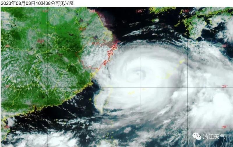
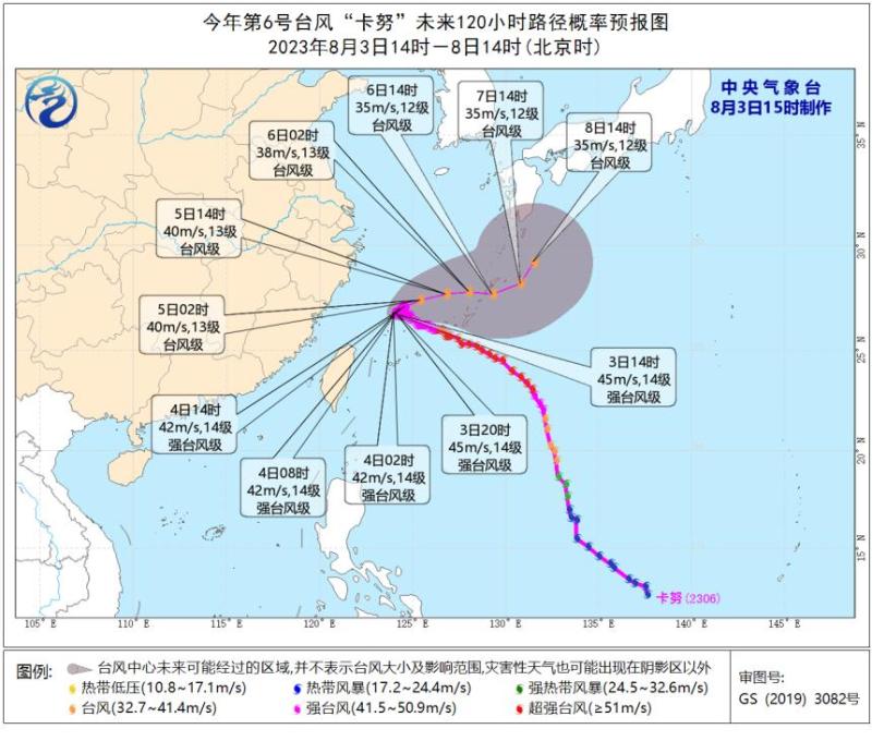
Typhoon Kanu, the 6th typhoon of this year, was located at 15:00 today on the sea surface about 335 kilometers southeast of Yuhuan City, Zhejiang Province. The center pressure was 950 hPa, with a maximum wind force of 14 levels and 45 meters per second. Kanu will remain stationary and its intensity will slowly weaken.
It is expected that "Kanu" will slowly move towards the west at a speed of 5-10 kilometers per hour, with little change in intensity. The maximum possibility is that it will turn northeast in the southern coastal area of Zhejiang from tonight to tomorrow morning. However, the possibility of close contact with the north coast of Zhejiang or landing in Zhejiang cannot be completely ruled out.
"Kanu" still has wind and rain impacts on Zhejiang
At present, "Kanu" has entered a 24-hour warning line, causing huge waves along the coast of Zhejiang. Everyone must pay attention to prevention!
Although the possibility of "Kanu" landing in Zhejiang is very small, due to its long stay in the East China Sea and the influence of its peripheral circulation, there will still be continuous wind and rain weather along the coast of Zhejiang.
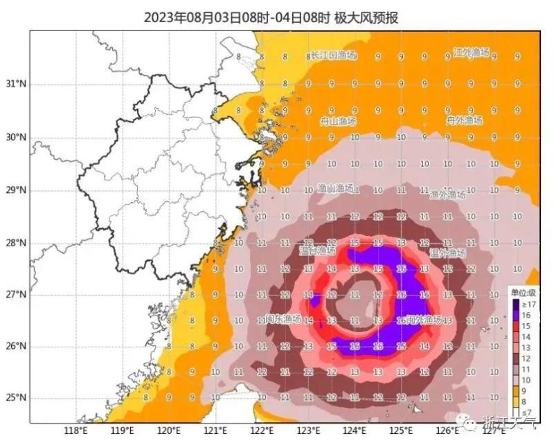
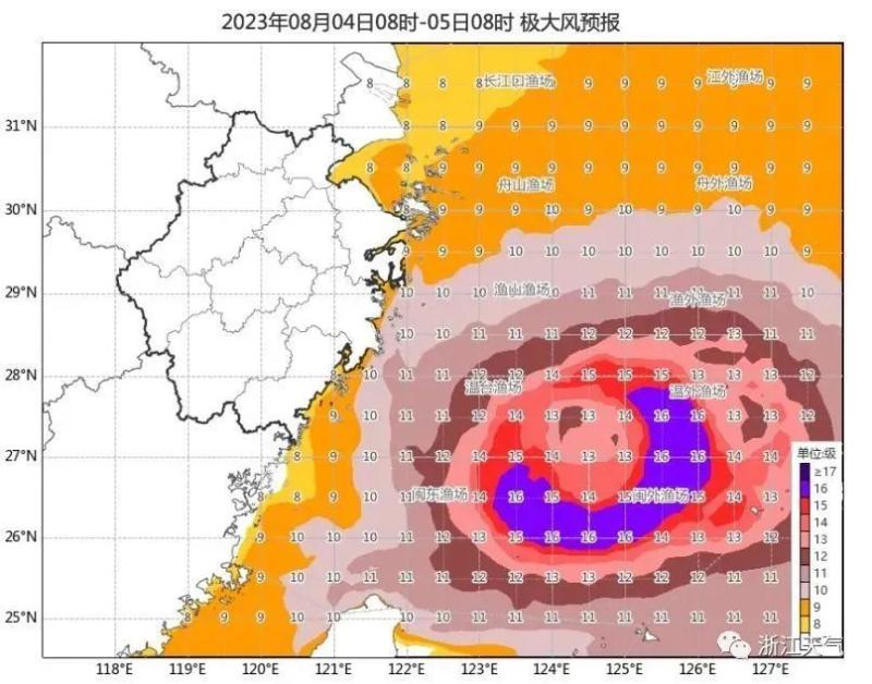
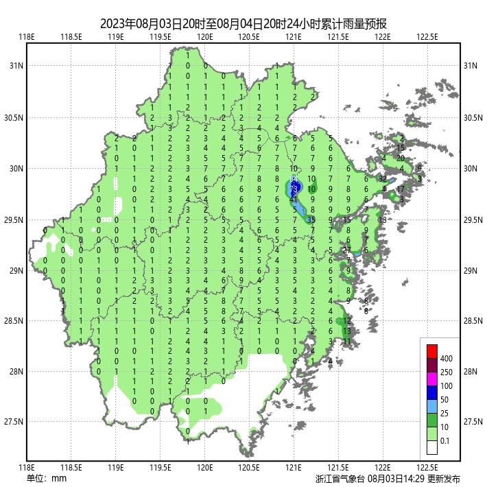
It is estimated that there will be moderate to heavy rain, partial rainstorm and individual heavy rainstorm in the coastal areas of north central Zhejiang today and tomorrow; Gusts of 9-11 levels in the northern waters of the East China Sea, gusts of 13-15 levels in the central and southern waters of the East China Sea, and gusts of 16 levels or above in the vicinity of the typhoon center; Coastal sea surface gusts of 9-11 levels; Today, there are 6-8 levels of gusts in some parts of the eastern region, with some areas experiencing 9-10 levels of gusts.
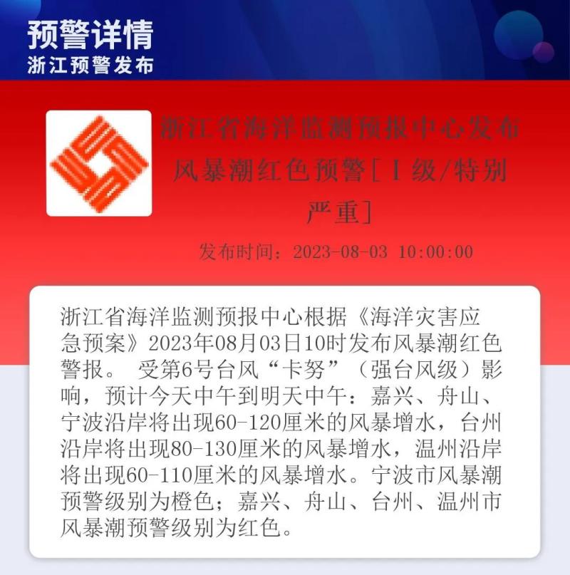
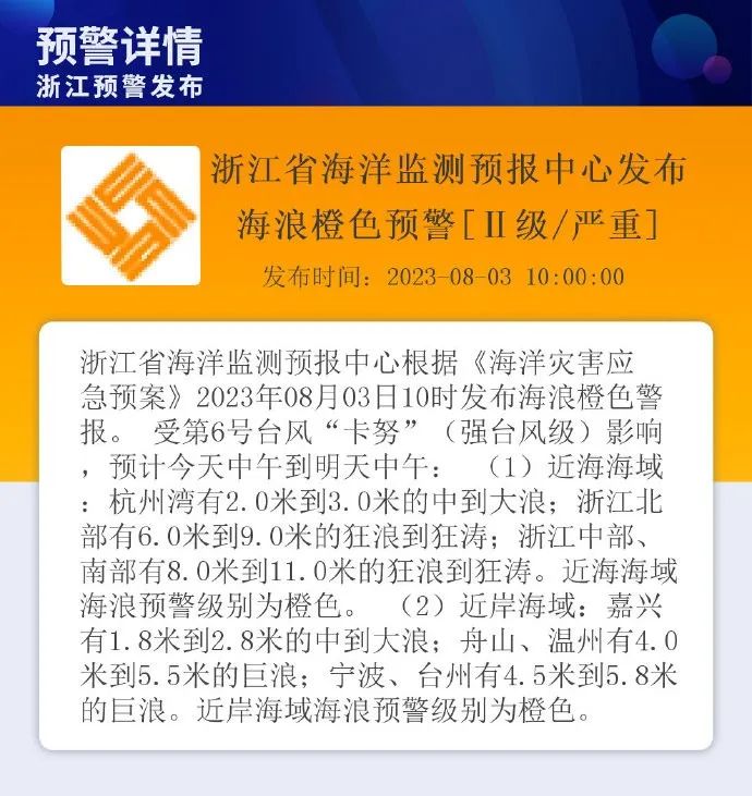
According to the Emergency Plan for Marine Disasters, the Zhejiang Provincial Marine Monitoring and Forecasting Center issued a red warning for storm surges and an orange warning for ocean waves at 10am today.
Ships at sea still return to the port to take shelter from the wind, and coastal friends should not go to watch the waves. Those who want to travel nearby should wait a little longer until the wind and waves are calm before going.

The combination of afternoon thunderstorms and high temperatures will return
From this afternoon to tomorrow: there are cloudy to cloudy showers or thunderstorms in the coastal areas of Zhejiang, including moderate to heavy rain in the central and northern coastal areas, local rainstorm, and individual heavy rainstorm; Other areas are mostly cloudy with scattered thunderstorms. The above thunderstorm areas can be accompanied by short-term rainstorm.
The day after tomorrow: Coastal areas will be cloudy to cloudy with showers or thunderstorms; Other areas are cloudy with scattered thunderstorms in the afternoon. The above thunderstorm areas can be accompanied by short-term rainstorm.

After the "Kanu" turn, the weather in various parts of the province will gradually return to the standard summer mode, with frequent thunderstorms and high temperatures starting to rise in the afternoon.
During the period after August 9th to the period after August 11th, there was a precipitation process from west to east in the province due to the influence of low-level vortex shear and the eastward movement of the high-altitude trough.
Future weather conditions in Zhejiang
★
August 6-7
The whole province is cloudy, with some cloudy showers or thunderstorms in the afternoon.
★
August 8-9
The whole province is cloudy, with some areas being cloudy and experiencing showers or thunderstorms.
★
August 10-11
The whole province is cloudy to cloudy with showers or thunderstorms.
★
August 12th
Coastal areas may experience showers or thunderstorms; Other areas are cloudy, with thunderstorms in some areas in the afternoon.
This typhoon warning big data report, please check it out
Comprehensive information from the Central Meteorological Observatory and Zhejiang Weather


