The wind in Guangzhou has started to weaken, and Macau has issued Signal No. 8. Typhoon "Sura" is gradually moving away from Hong Kong and Macau, and the signal will continue to maintain Hong Kong and Macau
According to the Hong Kong Observatory, Typhoon Sura continues to move away from Hong Kong, but many parts of the city are still affected by strong winds. The No. 8 strong wind or storm signal will be maintained until noon at least, urging citizens not to relax their windbreak measures.
Affected by the storm surge, the water levels in Tai O and Tsim Bi Tsui will rise to over 3 meters above the chart reference level from 9am to 12pm this morning.
As Typhoon Sura gradually moved away from Macau, the Macau Bureau of Geophysics and Meteorology issued the No. 8 southeast wind signal at 6:00 am on the 2nd. It is reported that Typhoon "Sura" has passed within a 30 kilometer radius of Macau and continues to move in a southwest southwest direction. The wind is gradually weakening, but it will still maintain wind speeds of 8 to 9 levels and gusts. Due to factors such as the "Sura" rain belt and astronomical tides, there will still be heavy showers and thunderstorms in Macau today and tomorrow, and low-lying areas may experience flooding.
In addition, after the issuance of Typhoon Signal No. 8, the lower lane of Sai Wan Bridge, which was closed due to the impact of the typhoon, resumed operation at 6 o'clock.
Typhoon makes landfall but still has the influence of wind and rain, and the wind in Guangzhou begins to weaken
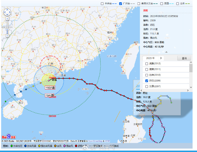
According to @ Guangzhou Weather, Typhoon "Sula" made landfall along the southern coast of Zhuhai City, Guangdong Province around 3:30 am on September 2nd, with a strong typhoon level. At 05:00, the center of "Sula" was located about 160 kilometers southwest of Guangzhou city. It is expected that "Sula" will gradually move away from Guangzhou at a speed of 15-20 kilometers per hour, and its intensity will gradually weaken.
Affected by Sura, strong winds were evident in Guangzhou last night, with gusts of 8-11 levels appearing in Nansha, Panyu, highlands, and bridges. Gusts of 6-9 levels were generally seen in the central and northern regions and low altitude areas. In the early morning, the wind in Guangzhou has weakened compared to the night, and it is expected that strong winds in Guangzhou will continue until this afternoon. Gusts in Nansha and Panyu gradually dropped to levels 6-8; The gusts in the central six districts and Zengcheng have dropped to levels 5-7, while the gusts in Conghua and Huadu have dropped to levels 4-6.
In terms of rainfall, there was a rainstorm in Guangzhou from the morning to the night of the 2nd, with local heavy rainstorm, mainly affecting Nansha, Panyu, Zengcheng and central six districts. The cumulative rainfall in the above-mentioned areas ranges from 80 to 120 millimeters, with some areas exceeding 200 millimeters; Accumulated rainfall in other areas ranges from 60 to 100 millimeters. Maximum hourly rainfall intensity: 10-30 millimeters, locally 40-60 millimeters.
In terms of early warning, yellow and higher level early warning signals for rainstorm and thunderstorm and gale will be issued from the 2nd to the 3rd, and the typhoon early warning signals will be downgraded or cancelled in each district during the daytime on the 2nd.


