The Central Meteorological Observatory continues to issue a red warning for rainstorm. Many places in the north are encountering continuous heavy rain and strong wind | weather | warning north
Affected by the residual circulation of Typhoon Dussuri, the fifth typhoon of this year, many northern regions have experienced large-scale heavy rainfall in the past two days.
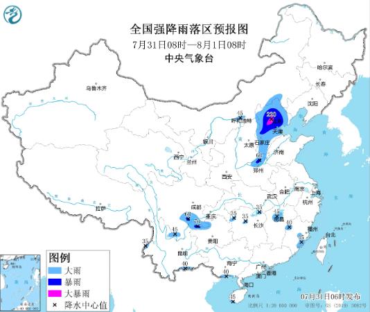
At 6:00 on July 31, the Central Meteorological Station continued to issue a red warning for rainstorm: since July 29, heavy to rainstorm has occurred in central and southern Hebei, eastern Hebei, most of Beijing, Tianjin, central and eastern Shanxi, most of Henan, central and western Shandong, and the northern part of the peninsula. heavy rainstorm has occurred in parts of central and southern Beijing, central and southern Hebei, northeast Hebei, northern Henan, eastern Shanxi, and western Shandong, and extremely heavy rainstorm has occurred in parts of central and southern Hebei, southwest Beijing, and northern Henan. The maximum hourly rainfall intensity in most regions is 20 to 50 mm, and the local area exceeds 80 mm. It is estimated that from 8:00 on July 31 to 8:00 on August 1, there will be heavy rain to rainstorm in most of Hebei, Beijing, Tianjin, eastern Shanxi and other places, among which, there will be heavy rainstorm in parts of central Hebei, central and western Beijing and other places; Scattered heavy rain or rainstorm occurs in the south central Inner Mongolia, northern Henan, northern Jiangxi, northeastern Yunnan, southern Sichuan, northwestern Guizhou, coastal areas in southern Guangxi, and southwestern Hainan Island. Some areas mentioned above have short-term heavy rainfall, and locally there are strong convective weather such as thunderstorms and strong winds.
National heavy rainfall forecast map
Defense Guidelines:
1. The government and relevant departments shall do a good job in emergency and rescue work against rainstorm according to their responsibilities.
2. Suspend gatherings, classes, and business operations.
3. Carry out defense and rescue work for disasters such as flash floods, landslides, and mudslides.
The Central Meteorological Administration has issued a yellow warning for severe convective weather
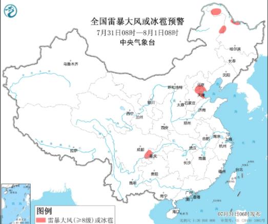
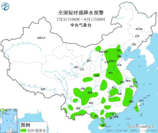
The Central Meteorological Observatory continued to issue a yellow warning for severe convective weather at 6:00 pm on July 31. It is expected that from 8:00 pm on July 31 to 8:00 pm on August 1, some areas in northwestern Heilongjiang, central Hebei, southeastern Beijing, Tianjin, southeastern Sichuan, and western Chongqing will experience 8-10 level thunderstorms, strong winds, or hail weather; Parts of Inner Mongolia, central and western parts of Shaanxi, central and eastern parts of Shanxi, Hebei, Beijing, Tianjin, western Shandong, Henan, central and northern parts of Anhui, Shanghai, central and western parts of Hubei, western and southern parts of Hunan, central and northern parts of Jiangxi, northeastern and southern parts of Zhejiang, northern and southeastern parts of Fujian, northern and southeastern parts of Sichuan, western parts of Chongqing, northern parts of Guizhou, central and southern parts of Yunnan, eastern and southwestern parts of Guangxi, coastal areas in central and southwestern Guangdong, northeastern parts of Hainan Island, and central and southern parts of Taiwan Island will experience short-term heavy rainfall, with hourly rainfall of 30-50 millimeters and locally reaching over 60 millimeters. It is expected that the main impact period of strong convection will be from day to night.
National thunderstorm, strong wind or hail warning
National Short term Heavy Rainfall Warning
Defense Guidelines:
1. The government and relevant departments shall do a good job in emergency defense against short-term rainstorm, lightning protection and strong wind according to their responsibilities, and the meteorological department shall prepare for manual hail suppression and select the right time to operate.
2. Drivers should slow down and confirm safety when passing through waterlogged roads. Traffic management departments should take traffic control measures and guidance on heavy rainfall and waterlogged roads based on road conditions.
3. Outdoor personnel should reduce or suspend outdoor operations in open areas, choose to enter buildings with strong wind resistance and lightning protection measures, and close doors and windows to stay away from dangerous power sources.
4. Airports, railways, highways, and water transportation units should take measures such as flight restrictions, speed limits, or temporary closures to ensure personnel and traffic safety. Water operations in relevant water areas and passing ships should return to the port to avoid and reinforce port facilities.

5. Check the drainage systems of cities, farmland, and fish ponds, take necessary drainage measures, and prepare for disasters such as flash floods, landslides, and mudslides.


