The center of gravity of rainfall in the north will shift to the northeast! Red warning of rainstorm will be issued here. Rainfall | center of gravity | warning in the next few days
In the coming days
The focus of rainfall in the north will shift to the northeast region
today
Local areas in southeastern Heilongjiang and central eastern Jilin
There will be rainstorm or heavy rainstorm
The focus of rainfall in the north will shift to the northeast region
Long duration of rainfall
In the next few days, with the transportation of warm and humid air from the periphery of the subtropical high pressure, combined with the cooperation of cold air, the center of gravity of rainfall in the north will shift to the northeast region. The duration of rainfall in the northeast region is relatively long, and there may be severe convective weather in some areas.
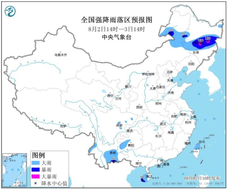
The Central Meteorological Station continued to issue a blue rainstorm warning at 10:00 on the 2nd. It is estimated that from 14:00 on the 2nd to 14:00 on the 3rd, there will be heavy to rainstorm in parts of Northeast Inner Mongolia, South Heilongjiang, West and North Jilin, Southwest Sichuan Basin, West Guizhou, Central and South Yunnan, Midwest Hainan Island and North Taiwan Island, among which, there will be heavy to heavy rainstorm in parts of Southeast Heilongjiang, North Jilin and other places. The above-mentioned areas are accompanied by short-term heavy rainfall, and locally there are strong convective weather such as thunderstorms, strong winds, and hail.
At 9:25 on August 2, the rainstorm red warning was issued by the Heilongjiang Meteorological Station. In the past three hours, 91.7 mm of rainfall has occurred at the Limudian Meteorological Station in Zhaodong, and it is expected that the rainfall will continue. There will be 20-40 mm of rainfall, and the cumulative rainfall will reach more than 100 mm. At 10:50 on the same day, the rainstorm red warning was issued again by the Heilongjiang Meteorological Station. In the past two hours, the Harbin Duiqing Town Meteorological Station has seen 85.5mm rainfall, and it is expected that the cumulative rainfall in three hours will exceed 100mm.
The Heilongjiang Provincial Meteorological Observatory predicts that from August 2nd to 4th, the cumulative precipitation in the southeast of Harbin and the central and southern parts of Mudanjiang will be 100 to 220 millimeters, and locally 250 to 310 millimeters; The southern part of Qiqihar, the southern part of Daqing, the central part of Harbin, the northern part of Mudanjiang, the Qitaihe River, and the western part of Jixi range from 40 to 80 millimeters, and can reach up to 100 millimeters locally. At 17:00 on August 1st, the Flood Control and Drought Relief Command of the People's Government of Heilongjiang Province has launched a Level 4 emergency response for flood control.
It is understood that from August 2nd to 4th, the areas with higher precipitation in the southern part of Heilongjiang Province highly overlap with the areas with stronger precipitation in the early stage, resulting in a high risk of secondary disasters. On August 1st at 15:00, the Flood Control and Drought Relief Command Office of the People's Government of Heilongjiang Province, the Water Resources Department of Heilongjiang Province, and the Meteorological Bureau of Heilongjiang Province jointly issued a meteorological risk warning for floods in small and medium-sized rivers. From 20:00 on August 1st to 20:00 on August 5th, there was a high meteorological risk for floods in small and medium-sized rivers in the entire Harbin and Mudanjiang districts. There was a high meteorological risk for floods in small and medium-sized rivers in Zhaodong, Lanxi, Qing'an, and Tieli, while there was a meteorological risk for floods in small and medium-sized rivers in Nianzishan, Longjiang, Gannan, and Fuyu.
Southern high temperatures will increase in development
Many areas in South China may have a body temperature exceeding 40 ℃
Recently, under the influence of rainfall, there has been no significant high temperature weather in the central and eastern regions. However, in the coming days, as the rainfall gradually weakens or recedes, the range of high temperatures will expand significantly.
Today, the high temperature is only scattered in Jianghan and Jiangnan areas. The highest temperature in many places from North China Plain to South China will reach 35~37 ℃ and the highest temperature in local areas will reach 38~39 ℃ in the next day or the next day. Many areas in South China may experience temperatures exceeding 40 ℃.
The possibility of typhoon "Kanu" landing in China is decreasing
There is still uncertainty in the later stage path
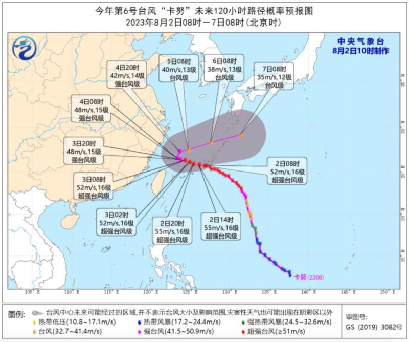
The Central Meteorological Observatory continued to issue a blue typhoon warning at 10:00 on the 2nd. The center of Typhoon Kanu, the 6th typhoon of this year, was located at 8:00 on the 2nd in the East China Sea, about 610 kilometers southeast of Yuhuan City, Zhejiang Province. The maximum wind force near the center was 16.
However, in terms of the current situation analysis of "Kanu", the possibility of landing is decreasing and the possibility of turning is increasing. It is most likely to move in a northeast direction near the southern coast of Zhejiang from the night of the 3rd to the morning of the 4th. Although the probability of landing in our country has decreased, it is still possible to move northward or make landfall along the coast of Zhejiang Province, and there is still uncertainty in the later path of the "Kanu" project.
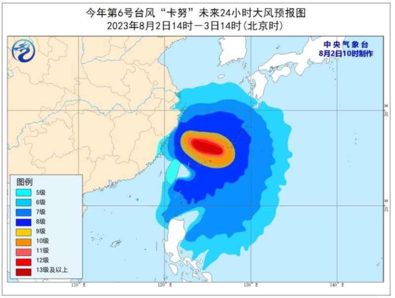
Gale forecast: From 14:00 on the 2nd to 14:00 on the 3rd, there will be strong winds of 6 to 8 levels and gusts of 9 to 10 levels in the Bashi Strait, the waters east of Taiwan, the East China Sea, and the waters near the Diaoyu Islands, as well as in the Yangtze River Estuary, Hangzhou Bay, the coastal areas of Zhejiang, the northern coastal areas of Fujian, and the northern coastal areas of Taiwan Island.
This article


