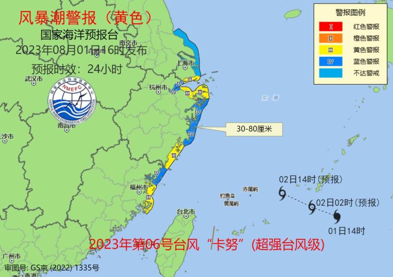
Shanghai, Ningbo, Zhoushan, Wenzhou, and Fuzhou have sounded yellow alerts for storm surges, and "Kanu" is near the East China Sea | waters | Zhoushan
On August 1st, Pengpai News learned from the Ministry of Natural Resources that due to the impact of Typhoon Kanu, the 6th of this year, it is expected that there will be 8 to 12 meters of rough waves in the southeast of the East China Sea in the next two days, and the sea conditions in the affected area will be severe. According to the Emergency Plan for Marine Disasters, the National Oceanic Forecasting Administration has upgraded the wave warning to orange.
According to the Central Weather Bureau, the center of Typhoon Kanu, the 6th typhoon of this year, was located at 14:00 today on the northwest Pacific Ocean, about 820 kilometers southeast of Yuhuan City, Zhejiang Province. Kanu will move towards the northwest at a speed of 10-15 kilometers per hour and is expected to enter the East China Sea tomorrow.
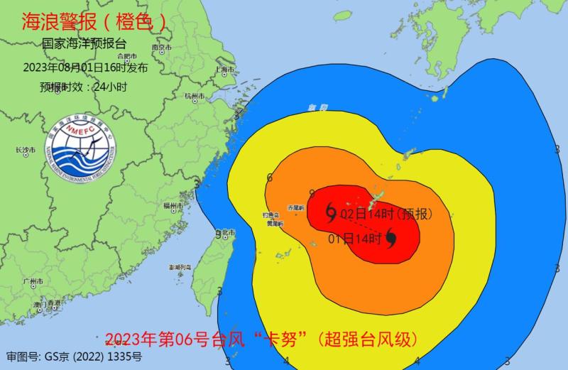
Affected by Typhoon Kanu, the 6th typhoon of this year, it is expected that from the night of August 1st to the day of August 2nd, there will be 8 to 12 meters of rough waves to the rough wave zone in the southeast of the East China Sea, 4 to 7 meters of giant waves to the rough wave zone in the southwest of the East China Sea and the waters near the Diaoyu Islands, 2.5 to 4 meters of large waves to the rough wave zone in the north of the East China Sea, and the wave warning level in the nearshore waters is orange; Large waves of 2.5 to 3.5 meters will appear in the nearshore waters of Zhejiang, with a yellow wave warning level. In the nearshore waters of northern Fujian, there will be 2 to 3 meters of medium to large waves. In the nearshore waters of Shanghai, there will be 1.5 to 2.5 meters of medium to large waves, with a blue wave warning level. Please pay attention to the safety of ships operating in the above-mentioned sea areas, and relevant coastal units should take measures to prevent and avoid waves in advance.
The National Oceanic Forecasting Station simultaneously sounded a yellow storm surge warning. It is expected that from the afternoon of August 1st to the night of August 2nd, there will be a storm surge of 30 to 80 centimeters along the coast from Nantong, Jiangsu to Fuzhou, Fujian. The storm surge warning level for Shanghai, Ningbo, Zhoushan, Wenzhou, and Fuzhou in Zhejiang Province is yellow. The storm surge warning level for Jiaxing City, Shaoxing City, Taizhou City, and Ningde City in Zhejiang Province is blue. Due to the high astronomical tide in the coastal section affected by the typhoon, it is necessary to pay special attention to the astronomical tide period at night along the coast, and there is still uncertainty in the typhoon path. The National Oceanic Forecasting Administration will closely monitor and remind coastal governments and relevant departments to make emergency preparations for defending against storm surges according to their responsibilities.