Right beside us (frontline research), Beidou Precision | Satellite Navigation | Frontline
data
data
Beidou, since ancient times, has always specifically referred to the seven stars in the northern sky who set the direction of the Four Seasons Survey. Today, when we talk about Beidou, it is a set of shining Chinese satellites in space.
Three years ago, with the last global network satellite of Beidou-3 successfully entering its designated orbit, the deployment of the Beidou-3 global satellite navigation system constellation was fully completed.The Beidou system has entered a new stage of global development.
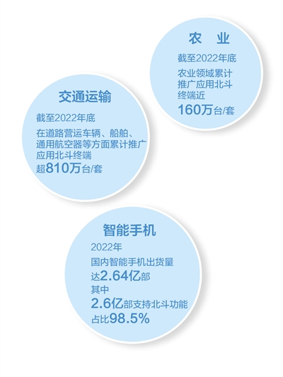
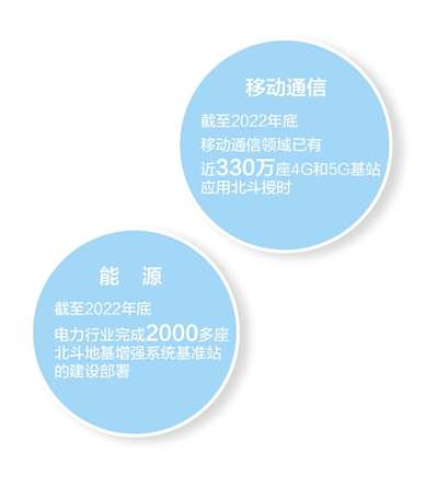
From Beidou-1 to Beidou-3, from covering the Asia Pacific to serving the world, as an important new type of infrastructure, the Beidou system deeply empowers various industries and becomes the cornerstone of economic and social development in time and space. In 2022, the overall output value of China's satellite navigation and location service industry exceeded 500 billion yuan, generating significant economic benefits.
The Beidou is far in the sky, and the application is close by our side. Nowadays, BeiDou has achieved a dominant position in the field of navigation maps in China, with an average daily usage of BeiDou positioning services exceeding 360 billion times. At this moment, at different altitudes and angles from the Earth's surface, the Beidou satellite is constantly in operation, providing 24/7, 24/7, high-precision positioning, navigation, and timing services to users in over 200 countries and regions around the world.
Today, we will enter the world of Beidou together and perceive how this system can serve economic and social development, and how it can better meet the needs of the people for a better life.
——Editor
Coordinates: Haidian, Beijing Application: Autonomous driving
"Smart cars drive on the path of wisdom"
At Zhongguancun Software Park in Haidian District, Beijing, autonomous taxis equipped with LiDAR, millimeter wave radar, and cameras can be seen driving on the streets from time to time. Open the car hailing app "Carrot Run", enter the destination, and after a while, an autonomous taxi arrives by your side.
After entering the last 4 digits of the phone number on the touch screen next to the car door and completing identity verification, the car door will be unlocked. Sitting in the back seat, click on "Start Journey" on the screen, and the vehicle starts smoothly. During the driving process, the display screen in front of me displays a real-time 3D modeling image of the vehicle and surrounding road conditions, with a light blue "water wave" indicating the next driving route. When passing through traffic lights, sidewalks, or U-turns, the steering wheel automatically turns; When encountering complex scenes such as narrow road sections and passing cars, vehicles should respond promptly to ensure safety.
In recent years, the development of autonomous driving technology and industry has accelerated. The simple and friendly user experience is backed by multiple systems such as perception, decision-making, planning, and control, which are supported by multiple technologies such as artificial intelligence, 5G communication, LiDAR, and high-precision maps. Among them, the high-precision and highly reliable satellite navigation and positioning services provided by the Beidou system are indispensable basic capabilities.
"The combination of BeiDou satellite navigation and positioning services with inertial navigation technology can improve the efficiency and accuracy of offline high-precision mapping. The integration of BeiDou satellite navigation and positioning services with LiDAR positioning, visual positioning, etc. forms a safe positioning covering multiple scenarios." said Wang Chong, Chief Brand Officer of Baidu Intelligent Driving Business Group.
"Automatic driving means that smart cars drive on smart roads." Liu Jingnan, an academician of the CAE Member and director of the National Engineering Technology Research Center for Satellite Positioning System, said, "For 'smart cars', the response speed should reach microseconds and nanoseconds. If a car travels at a speed of 100 kilometers per hour, and the car has moved forward nearly 3 centimeters in 1 millisecond, there may be a safety risk. Beidou has been able to achieve centimeter level positioning and nanoseconds level timing, which can meet the control needs of automatic driving space-time position. For' smart roads', the high-precision map based on Beidou is the 'base' of driving environment information, which can reflect the accuracy of map targets in the real world The location also contains more abundant road traffic information to achieve path planning and navigation. Even in the case of vehicle sensor failure, high-precision maps can actively control the vehicle operation to change lanes and decelerate according to the road condition data."
The comprehensive support of Beidou system for vehicle terminals, roadside equipment, and cloud platforms makes autonomous vehicles more intelligent and efficient. "The environmental changes observed by car mounted sensors may be real-time changes. After matching with high-precision maps, the captured changes will be uploaded to the 'cloud' through roadside vehicle networking communication nodes in a timely manner. After verification and confirmation, this information will be summarized in the 'cloud' and actively pushed to the users in need, truly achieving a high degree of collaboration between vehicles, roads, and people." Liu Jingnan said.
The innovative driving force provided by the Beidou system has accelerated the emergence of autonomous driving: Baidu's autonomous driving travel service platform "Carrot Run" has a total test mileage of over 60 million kilometers and an order volume of over 2 million; Hexin Xingtong independently develops baseband chips, and the deep integration with microelectromechanical inertial navigation can optimize the continuity and reliability of positioning in complex environments such as buildings, tunnels, and elevated bridges
"The integration and development of BeiDou with emerging technologies such as 5G, Internet of Things, and artificial intelligence not only opens up huge market space in the field of autonomous driving, but also continuously expands diversified application scenarios in the field of intelligent transportation." Yu Xiancheng, President of the China Satellite Navigation and Positioning Association, said that the high-precision intelligent driving system of BeiDou has formed a trend of large-scale application development. The lane level navigation function based on high-precision BeiDou has been successfully piloted in 8 cities and gradually popularized nationwide.
Coordinates: Zhoushan, Zhejiang Application: Marine Fisheries
"Fishing boats can provide service guarantee for both entry and exit"
At Shenjiamen Fishing Port in Zhoushan City, Zhejiang Province, thousands of fishing boats are neatly arranged and lined with masts. At present, in addition to fishing gear boats and licensed fishing boats that can go out for production normally, the remaining over 1500 fishing boats are resting in the port.
"In the past, when encountering dangerous situations at sea, it was just a blink of an eye." Yang Yuejing, a 58 year old ship owner, walked into the cockpit with reporters and used devices such as the built-in Beidou Tiantong shipborne satellite phone and shipborne satellite broadband communication equipment. Pointing to the orange BeiDou ship position indicator on the ship, Yang Yuejing couldn't help but praise it: "With it, fishing boats going out to sea can not only accurately report their position, but also send alarm messages in case of signal loss or danger. Not only can they locate, but we can also listen to weather forecasts and warning notifications at sea." With the SMS and phone functions of BeiDou and TianTong, as well as the application of broadband devices, real-time fishing information can now be sent to fishermen, and fishing boats can quickly and accurately navigate to the location of fishing boats, pulling fresh fish in the first time. Moving the sales node forward ensures freshness in order to sell at a good price.
In addition to hardware devices, the precision intelligent control system of fishing boats based on high-speed operation of location information also demonstrates its capabilities.
In the duty room of the Information Center of Zhoushan Marine and Fisheries Bureau, the director of the center, Sun Pinghua, stared at the large screen as usual. The screen displays real-time information of each fishing vessel equipped with a BeiDou navigation and positioning terminal. Based on the analysis and prediction of location information, there is a risk of collision between a fishing boat 142.8 nautical miles away and a commercial ship on the route. The voice call immediately dialed out: Big ship route, pay attention to safety. Immediately received a reply from the fishing boat: "Thank you, I will pay attention to observation."
Sun Pinghua introduced that Zhoushan City uses electronic fences to delineate accident prone areas. If a fishing boat enters the designated area of the electronic fence, the system will trigger a warning signal. "Fishing boats' entry and exit can provide service guarantee. During the fishing season, if a fishing boat moves and exceeds a certain speed, the system platform will issue a warning to the corresponding vessel."
In Zhoushan, in addition to service management, Beidou has also nurtured many industries.
The mussel breeding base on Goji Island in Shengsi County has utilized a digital breeding management platform based on Beidou R&D, covering tens of thousands of acres of aquaculture water. Sun Hai, the developer of the management platform and the person in charge of Zhejiang Tongbo Technology Development Co., Ltd., said that by installing positioning equipment and establishing an electronic fence at sea, disputes over mussel farming caused by unclear water area division have been greatly reduced; The Beidou ocean detection buoy can provide real-time and accurate parameters such as water temperature, salinity, dissolved oxygen, pH value, turbidity, etc., helping farmers better understand water quality conditions and environmental changes.
Tongbo Company is a specialized and innovative enterprise in the fields of Beidou industry and ocean big data services in Zhejiang Province. The Beidou ship position indicator developed by the company has covered more than 80% of local fishing boats in Zhoushan. The newly developed life jacket with Beidou positioning device can automatically perceive and continuously report location information when a person falls into the water.
From the Tiantong shipborne satellite phone to the BeiDou personnel distress positioning system, and then to the BeiDou communication all-in-one machine and shipborne satellite antenna... In Zhoushan, the industrial tentacles based on the BeiDou system are extending to all aspects of marine fisheries, protecting the safety of fishermen's lives and property, and achieving sustainable development of marine fisheries.
Coordinates: Foshan, Guangdong Application: Smart Energy
"Build an accurate three-dimensional coordinate system for inspection"
A drone equipped with visible light and infrared thermometers completed the photography and temperature measurement of multiple key components of transmission equipment along the established iron tower route on West Third Ring Road, Shishan Town, Foshan City, Guangdong Province.
"This time, the planned time is 6 minutes and 28 seconds. We will use a remote control terminal to access the BeiDou high-precision positioning master station system through our account, select the automatic flight operation route, and complete the fine inspection of these towers." Huang Feng, the leader of the machine inspection operation team of Guangdong Foshan Power Supply Bureau of Southern Power Grid, said that the high-precision positioning at the centimeter level of BeiDou can accurately inform the location of drones.
"Relying on the Beidou system, a precise three-dimensional coordinate system for inspection is constructed. Through this spatial model, routes and waypoints are planned, and drones will not collide with lines, substations, etc. due to errors during inspection." Technical personnel Zeng Yihui explained on the side.
"Whether the insulators are heating up and whether the screws are loose, these parts are the most prone to faults. Previously, only the naked eye and handheld infrared thermometers could be used to determine." Recalling 10 years ago, Huang Feng and the transmission team had to rely on manual climbing to complete the acceptance and fault inspection of the transmission line, "when the height exceeded 40 meters, the iron tower could be felt to be shaking all the time, and when a base tower was patrolled, the whole body was soaked." Now, drones are used for inspection, photos are sent to the background, and precise analysis is carried out through point cloud technology. The generated report will be timely feedback to remind relevant departments to deal with hidden dangers.
By using drones equipped with LiDAR, infrared thermometers, night vision cameras, etc., most of the inspection work on power transmission lines has been turned into machine operation. According to statistics, as of the end of 2022, the cumulative autonomous inspection mileage of unmanned aerial vehicles by Southern Power Grid Company has exceeded 1 million kilometers, and more than 80 million photos have been collected during the autonomous inspection.
"We have been constructing a BeiDou ground-based enhancement system consisting of a BeiDou reference station, communication network, and data processing system since 2018, ultimately achieving centimeter level positioning." E Shenglong, the technical director of BeiDou at Guangdong Electric Power Science Research Institute of Southern Power Grid, said that during this process, we also encountered many difficulties. "For example, due to the influence of the solar activity cycle, we are located in low latitude areas in the south, where the ionosphere is relatively more active, and the positioning effect is affected. Therefore, we have visited the School of Surveying and Mapping at Wuhan University and the Guangdong Provincial Institute of Land and Resources Surveying and Mapping, and have had multiple technical exchanges with equipment and positioning service manufacturers in the industry."
"At first, people were not accustomed to using this system, but later with the improvement of algorithms and technological advancements, they became more and more proficient. Next, we will continue to carry out optimization of positioning algorithms and encryption of benchmark stations to continuously improve the reliability of Beidou positioning," said E Shenglong.
At present, Southern Power Grid is based on a high-precision service network composed of 617 Beidou positioning reference stations, cultivating Beidou application scenarios in 16 fields such as unmanned aerial vehicle autonomous inspection, transmission tower disaster monitoring, on-site emergency repair communication, etc. It has promoted more than 120000 sets of domestically produced Beidou terminal applications, supporting the basic full coverage of unmanned aerial vehicle autonomous inspection of transmission lines and Beidou timing in the main power grid dispatch field, improving information transmission and personnel positioning in emergency situations, intelligent and efficient management of vehicle safety, and solving the problem of power information transmission in areas without public networks or unstable public network signals, fully supporting the digital transformation of the power grid.

Coordinates: Mianyang, Sichuan Application: Early warning and monitoring
"With the 'stars' guarding the sky, it's much more reassuring."
"There is a risk of deformation and displacement detected at the hidden danger point, please go to the site immediately for inspection and verification." The night outside the window grew darker, and geological hazard monitor Liao Dehua's phone was illuminated by a warning text message. He quickly left the door.
Liao Dehua is a villager from Lianhua Village, Huangtu Town, Mianyang City, Sichuan Province. The village is located on a shallow hill and is constantly plagued by geological disasters. He moved into the village in 2011, and the open flat land not far from his house collapsed nearly 8 meters in a landslide, which has now turned into a slope.
In order to protect the safety of his fellow villagers, Lao Liao served as a geological hazard monitor. "I have learned disaster prevention knowledge through training, but I am still nervous when monitoring the disaster situation." After more than 6 years of service, his experience is to walk and see more, and the situation on the ground must be carefully patrolled every time.
In 2021, the local natural resources department carried out landslide control for Lianhua Village, and a batch of disaster monitoring equipment using the Beidou satellite navigation system entered the site. "Two monitoring stations have been set up in the main sliding direction of the landslide, using the BeiDou system to collect real-time data and monitor the deformation and displacement of the geological hazard surface. Walking in the hidden danger area, Gu Xuan, an engineer from Sichuan Jiuzhou BeiDou Navigation and Location Service Co., Ltd., introduced that equipment such as rain gauges and crack gauges are installed in place. These front-end sensors can sense small changes at the millimeter level and are connected to the BeiDou system to transmit the data to the safety monitoring and early warning platform.".
"With the 'stars' guarding the sky, it's much more reassuring." In the past two years, Lao Liao's monitoring burden has become much lighter, just pay attention to warning messages and follow the instructions to patrol in a timely manner. Engineers conduct monthly inspections and timely calibration of monitoring equipment, striving to minimize data errors.
Entering the Command Hall of Mianyang Natural Resources and Planning Bureau, the Sichuan Provincial Geological Disaster Professional Monitoring and Early Warning Platform is in operation. The 3D+VR panoramic map is marked with densely packed disaster hazard points, and real-time data such as changes in the inclination angle of the hazard body and precipitation are transmitted back to the platform for analysis, becoming the basis for issuing instructions.
Since 2018, the Natural Resources and Planning Bureau of Mianyang City has introduced the Beidou system to assist in disaster prevention and reduction, and has built more than 1000 geological disaster group specialized monitoring points. "We can visually see the real-time environmental information of each point, and once the relevant data reaches the threshold, the platform will issue a warning of four levels: blue, yellow, orange, and red." Liu Hongyang, Director of the Geological Disaster Prevention and Control Department of Mianyang Natural Resources and Planning Bureau, introduced.
After the warning is issued, grassroots monitoring personnel will immediately go to the scene to provide feedback, and then the natural resources department's professional personnel will analyze and decide to lift the alarm or deal with the disaster situation. After reviewing the platform's disposal records, the reporter saw that cracks appeared at the landslide hazard point in Xiba Village, Pingwu County last year. The warning went from blue to red, and the geological data, trend, and on-site pictures around the cracks were under monitoring. Residents around the cracks had already evacuated before the landslide occurred.
"The monitoring accuracy has been greatly improved, and peaks and cliffs that cannot be reached by monitoring personnel are no longer blind spots. All weather monitoring has also been successfully achieved," said Liu Hongyang.
The stars weave into a safety net. The inclination, strain, vibration, and passing vehicle loads of the bridge; The deformation, structural stress, and geological environment dynamics of the tunnel can be comprehensively monitored using the Beidou system. "On this basis, we will also introduce technologies such as digital twins and lightning vision fusion to conduct virtual modeling of key monitoring areas, and use historical data, real-time data, and algorithm models to achieve analysis and prediction, further improving disaster warning and monitoring capabilities." said Deng Jian, Director of the Engineering Department of Sichuan Jiuzhou Beidou Navigation and Location Services Co., Ltd.
According to statistics, as of June 2022, the "Beidou+Security Intelligent Monitoring and Early Warning Cloud Platform" has set up over 8000 monitoring points in water conservancy, emergency and other fields in 20 provinces.
format


