Our country's first set! Observing the sky and rain with double eyes
Upon hearing the roar of the rocket igniting and taking off, Yang Runfeng, who was testing the data in the factory building, had mixed feelings.
"Just like a child who has been raised for many years, suddenly really left you," he recalled in an interview with a reporter from Science and Technology Daily.
On April 16th this year, China's first dedicated precipitation measurement satellite, Fengyun-3G, was launched. Its main payload was China's first spaceborne Ku and Ka dual frequency precipitation measurement radar developed by the 704 Institute of the Ninth Academy of China Aerospace Science and Technology Group. As of the time of the reporter's press release, the radar has successfully detected the three-dimensional fine structure of precipitation in mid to low latitude regions around the world with its sharp "double eyes", capturing the three-dimensional structure of typhoon rainfall systems such as "Mawa" and "Taili". During the rainstorm in North China in August, the radar accurately detected the three-dimensional fine structure information of precipitation, providing valuable observation data for disaster prevention and mitigation.
On April 16, 2023, China's first precipitation measurement satellite, Fengyun-3G, was successfully launched. Photo by Wang Jiangbo
As the chief designer of the precipitation measurement radar for 704 Fengyun-3G satellites, Yang Runfeng and his colleagues have worked hard for 17 years to produce this product. The young man who was once full of energy has now given birth to blossoming hair.
Building radar through a dual approach
China is located in the western typhoon activity belt of the North Pacific, and typhoon rainstorm waterlogging has always been the main natural disaster faced by some regions.

Obtaining precipitation data mainly relied on methods such as rain gauges and ground-based radars in the past, but due to limitations in the number and distribution of equipment, it is difficult to obtain large-scale and high spatial resolution ground precipitation information. In 1997, the United States and Japan jointly launched the TRMM satellite carrying precipitation radar, pioneering the use of spaceborne radar to detect precipitation and providing reference ideas for the development of China's new generation of low orbit wind and cloud meteorological satellites.
At the beginning of the 21st century, researchers from 704 Institute began collecting materials and conducting preliminary research on spaceborne precipitation radars. They keenly noticed that compared to the single frequency radar used by the TRMM satellite, the dual frequency precipitation radar performs better in practical applications.
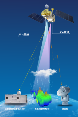
"Ku and Ka dual frequency precipitation measurement radars can combine the advantages of high radar observation resolution and wide satellite observation range." Jiang Bosen, director of the Microwave Remote Sensing Technology Research Office at 704 Institute, introduced that the Ku frequency band is conducive to detecting strong precipitation, and the Ka frequency band is conducive to detecting weak precipitation. Working together can expand precipitation detection capabilities, even for drizzle of 0.2 millimeters per hour, it can be accurately sensed.
Schematic diagram of dual frequency precipitation measurement radar operation. In addition, by utilizing the different scattering characteristics of precipitation particles on radar signals of different frequency bands, dual frequency measurement can distinguish rain, snow, hail, etc., and detect liquid and solid changes during the precipitation process, which is very important in meteorological applications.
At that time, the global precipitation observation program jointly implemented by the United States and Japan was not long in operation, and the spaceborne dual frequency precipitation radar was also in the exploratory stage internationally. "At that time, we thought to do our best," said Johnson.
At the Meteorological Satellite Development Forum held in 2006, the development of domestically produced precipitation measurement satellites became a consensus. 704 Institute bravely unveiled the list and shouldered the heavy responsibility of developing a satellite main payload precipitation measurement radar.
Make every effort to be a "ruler"
This is the first time that China has developed a satellite based precipitation measurement radar, which has a new direction and new technology, and scientific research work faces many challenges.
"The requirements for various indicators of this radar are very high, some of which were not present in domestic phased array radar products at that time, and there were many difficulties in design, processing, and manufacturing," said Yang Runfeng.
Even more difficult is the quantification requirements of the radar. Yang Runfeng introduced that taking equivalent radiation power as an example, conventional radar only requires radiation power to be greater than the target, and the specific amount is usually not required. But for quantitative radar, it is necessary to accurately determine the parameters of the radar system. It needs to become a ruler, and there must be measurement standards for measuring the intensity and intensity fluctuations.
This is the first time the development team has developed a quantitative radar. They can only slowly explore how to make the ruler accurate.
Dual frequency precipitation measurement radar. In July 2010, Yang Runfeng and his colleagues brought the product prototype to Sichuan for testing and debugging. It's midsummer, the weather is hot and humid, and mosquitoes are rampant. Yang Runfeng clearly remembers that during the field debugging, a colleague was not wearing gloves and was only stung 26 bags on the back of his right hand.
In September of that year, the preliminary testing and debugging were completed, and the development team rushed to Yancheng, Jiangsu to carry out airborne hanging flight tests without stopping.
Johnson introduced that airborne flight tests require several conditions to be met simultaneously: precipitation must be present without affecting flight; The observation height should be above 6000 meters; There should be meteorological satellites passing through the sky, and observation equipment should be installed on the ground. Through integrated observation of the sky, space, and ground, data can be compared and verified.

It is difficult to achieve ideal conditions. Jiang Bosen wore a down jacket, inhaled oxygen, and flew with him 7 times, most of which were unsuccessful.
At the same time, Yang Runfeng and his colleagues rented a village in the suburbs of Yancheng, with observation equipment installed on the roof. Due to TRMM satellites always passing through in the early morning, they had to work in the middle of the night. The strange behavior once caused great confusion among the landlord and villagers.
After more than two months of flight tests, the development team finally obtained the required data, laying the foundation for subsequent engineering development.
"Distinguishing" Rain Situation with Clear Insight
It is difficult to build radar, and it is even more difficult to make it capable of working in the sky.
Unlike most spaceborne radars that operate intermittently, the precipitation measurement radar needs to be continuously powered on within the 6-year design life of Fengyun-3G satellite, which means it needs to work continuously for at least about 53000 hours. Its reliability and long lifespan requirements have become challenges faced by the development team.
Yang Runfeng led the design team to explore the optimal balance among various constraints - by optimizing algorithms and resource allocation, to compensate for the weak processing capacity of high reliability chips; Design redundant backups for system level, single machine level, software level, and other aspects while meeting requirements for weight, volume, and power consumption.

Compared to ground radar, spaceborne radar looks down from the sky and faces many new problems, such as surface echoes interfering with detection. Johnson said that the surface echo signal is millions of times stronger than the precipitation echo signal. If it cannot be separated and eliminated well, the precipitation signal cannot be measured or even cannot be measured. The development team has carried out a lot of innovative research and development in this regard.
Schematic diagram of Fengyun-3 G star in orbit. The image is densely arranged in rows of gaps on the radar array, from which electromagnetic waves radiate. Jiang Bosen introduced that these tens of thousands of waveguide gaps are cut by precision machining equipment, with different widths, depths, and angles, which can control the magnitude and phase of electromagnetic wave energy at different positions in the array. This design can effectively suppress interference and solve many problems caused by observations in the sky.
Compared to the GPM satellites of the United States and Japan, the Fengyun-3 G satellite has a significant performance advantage. "In terms of observation bandwidth, our Ku and Ka band radars are 20% and 140% higher, respectively; under the same sensitivity conditions, our 'CT' scans one layer every 250 meters, with twice the precision," said Johnson.
At present, the in orbit testing of precipitation measurement radar runs stably, but the work in the hands of the developers has not slackened at all. While closely monitoring the radar's in orbit status, they have also invested in the development of other spaceborne precipitation measurement radars, as well as the research and development of the next generation of precipitation measurement radars.
"Meteorological work is closely related to life safety, production development, and ecological environment, and is a 'national priority' that concerns people's happiness and health." Yu Yong, the director of 704 Institute, told reporters, "The dual frequency precipitation measurement radar is the first step we have taken. In the future, we will continue to work hard in the field of microwave active meteorology, continuously introduce more advanced meteorological remote sensing instruments, and make greater contributions to China's move towards a 'meteorological power'!"


