Or you may log in here! Thunderstorms and strong winds are approaching Zhejiang, upgrading to a strong typhoon! "Dussuri" continues to strengthen China | Dussuri | strong typhoon
The fifth typhoon of this year, "Dussuri"
Coming with a fierce force
Upgraded to a strong typhoon!
Chinese Central Meteorological Station
10:00 on July 24th
Continue to issue typhoon forecasts:
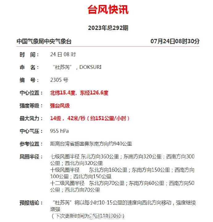
The 5th typhoon of this year, "Dussuri", strengthened from typhoon level to strong typhoon level at 8:00 am on the 24th. Its center is located in the ocean east of Luzon Island in the Philippines, approximately 940 kilometers southeast of Eluanbi, Taiwan Province, China.
It is expected that "Du Suri" will move towards the northwest at a speed of 10-15 kilometers per hour, with its intensity continuing to strengthen, reaching a maximum of super typhoon level. It will gradually approach the southern coast of Taiwan Island, move into the northeast of the South China Sea on the 27th, and then approach the coastal areas from central Fujian to eastern Guangdong.
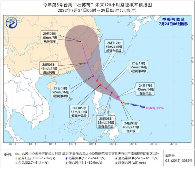
According to Xin Xin, a meteorological analyst at China Meteorological Channel, there is no doubt that "Du Suri" will make landfall in China in the later stage, and the only uncertainty is the landing location.
This morning,
China Meteorological Channel Meteorological Analyst
Xin Xin continues to post an analysis:
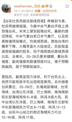
At present, there are more reports of direct landing in Fujian,
But it cannot be ruled out that after continuing the westward route, one will go to eastern Guangdong.
The 25th to 26th is a critical period,
Comparing typhoon intensity, subtropical high intensity, and numerical forecasts,
If it is stronger than expected, it will lean towards the west, and if it is weaker than expected, it will lean towards the east.
At present, Typhoon "Dussuri" is gradually approaching China
Affected by it
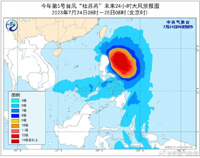
Today, gusts in the southeastern coastal waters of China can exceed 10 levels
At 06:00 this morning
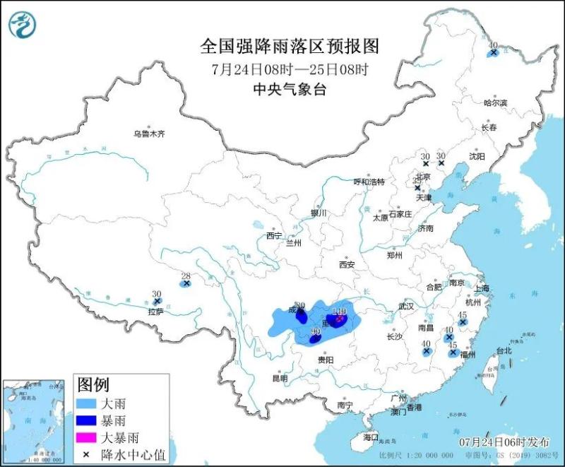
The Central Meteorological Observatory continued to issue a blue rainstorm warning
It is estimated that from 08:00 on July 24 to 08:00 on July 25, there will be heavy to rainstorm in parts of central and southern Sichuan Basin, most of Chongqing, northern Guizhou, northeastern Yunnan, southwestern Hubei, northwestern Hunan, southern Zhejiang, central and northern Fujian, southern Jiangxi, northern Heilongjiang, eastern Xizang, among which there will be heavy rainstorm in parts of southern Chongqing. The above-mentioned areas are accompanied by short-term heavy rainfall, and locally there are strong convective weather such as thunderstorms and strong winds.
The weather situation in Zhejiang is a bit complicated
The weather situation in Zhejiang this week is a bit complicated, with subtropical high and typhoons taking turns.
According to the Zhejiang Provincial Meteorological Observatory, due to the influence of the subtropical high and the southerly airflow outside the South China Sea tropical system, there will be frequent showers or thunderstorms in southern Zhejiang and coastal areas in the early part of this week. Other areas will have sunny and hot weather, and there will be local showers or thunderstorms from afternoon to night. Random rainfall still needs to be prepared with rain gear at all times.
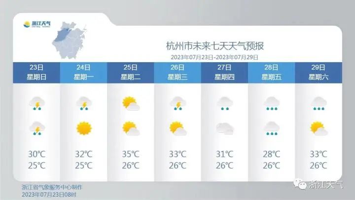
Taking Hangzhou as an example, there are still many showers or thunderstorms from this afternoon to the first half of the night. Due to the continuous water vapor transportation from the southwest wind source on the west side of the subtropical high, and the eastward movement of the high trough, there may be short-term rainstorm, thunderstorm, gale and other severe convective weather during thunderstorms.
The Hangzhou Meteorological Observatory reminds that due to the continuous occurrence of thunderstorms in recent times, the disaster risk level in various regions is currently very high. If there is strong precipitation and strong winds again, the possibility of disasters is high. It is necessary to pay attention to weather forecasts in a timely manner and be prepared for defense.
In the middle of this week, our province experienced a precipitation process due to the influence of the typhoon's main circulation and trough. In the later stage, as the typhoon moved northward, the subtropical high returned to level C on the weather stage.
In addition, yesterday we ushered in the Great Heat season, which is also a period of concentrated generation and landing of typhoons in the South China Sea and Northwest Pacific. The impact of typhoons in the coastal areas of East China and South China may "continue to rise one after another". The meteorological department reminds that all regions need to prepare in advance for typhoon prevention.
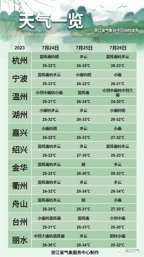
Recent specific weather conditions in Zhejiang:


