Not ruling out the possibility of login, it will also be enhanced! Zhejiang Level III Emergency Response, Typhoon Kanu Breaks 24-hour Warning Line | East China Sea | Local
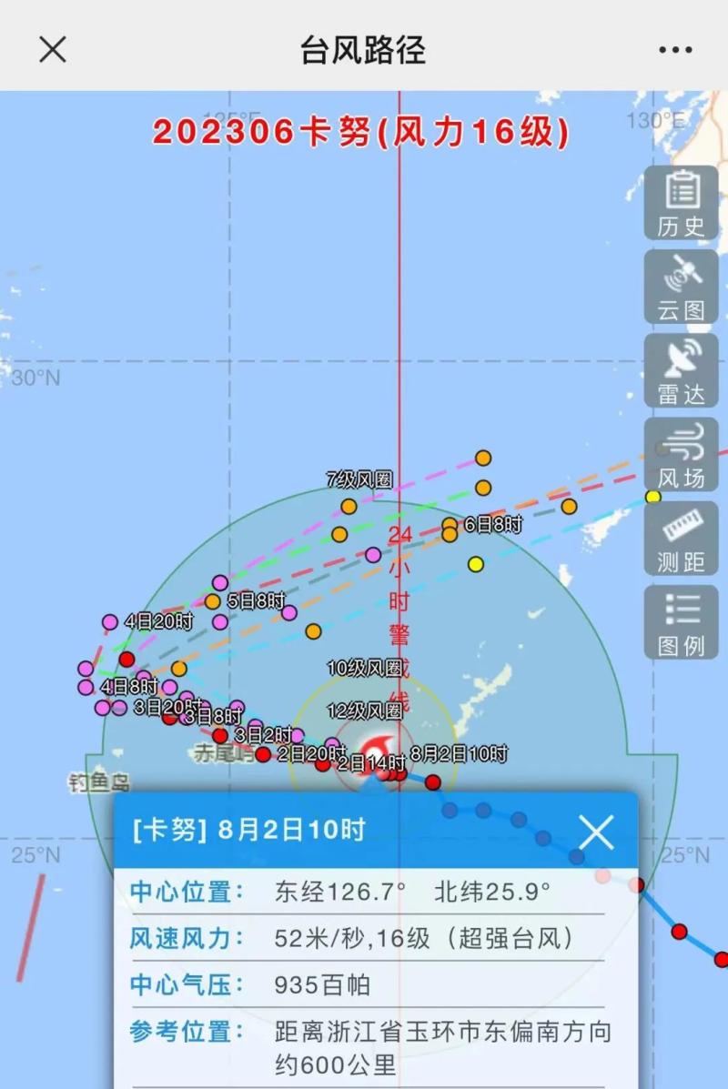
Typhoon Kanu's landfall point
Difficulty in determining path trajectory
But now it is getting closer and closer to Zhejiang!
10am
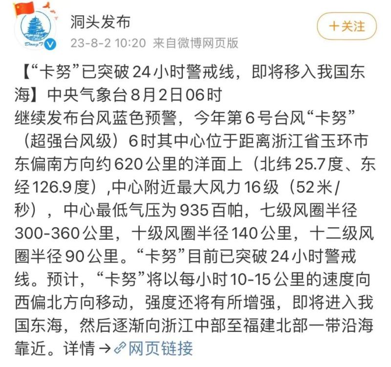
The Central Meteorological Observatory continues to issue a blue typhoon warning:
The center of Typhoon Kanu, the 6th typhoon of this year, was located at 8 o'clock this morning on the sea surface of the East China Sea, about 610 kilometers southeast of Yuhuan City, Zhejiang Province. It is 25.7 degrees north latitude and 126.8 degrees east longitude, with a maximum wind speed of 16 levels and 52 meters per second near the center. The minimum pressure at the center is 935 hPa, and the radius of the 7th level wind circle is 300-360 kilometers, the radius of the 10th level wind circle is 100 kilometers, and the radius of the 12th level wind circle is 50 kilometers.
According to @ Dongtou's announcement
Typhoon Kanu has broken through the 24-hour warning line
▼
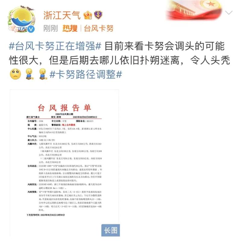
According to Zhejiang Weather News:
At present, there is a high possibility that Kanu will turn around,
But where to go in the later stage is still uncertain.
Sea typhoon warning!
Kanu is about to enter the East China Sea
Strong winds will continue for three days along the coast of Zhejiang
The Zhejiang Provincial Meteorological Observatory issued a typhoon warning for the sea at 9am this morning:
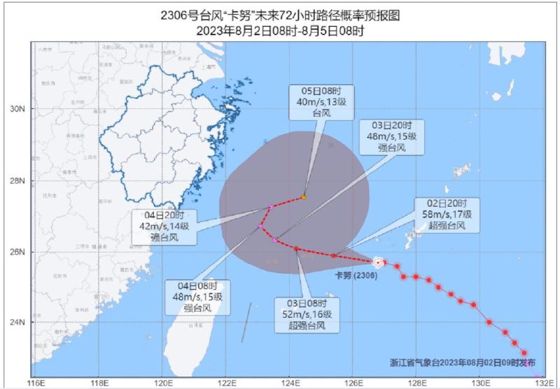
It is expected that Kanu will move towards the northwest direction at a speed of 10-15 kilometers per hour, and its intensity will also increase. It is about to move into the southeastern waters of the East China Sea, and then slowly move towards the northwest direction. The maximum possibility is that it will turn northeast in the southern waters of Zhejiang from the night of the 3rd to the morning of the 4th, but it is still not ruled out that it may tightly graze the coast of our province and move northward or land in our province.
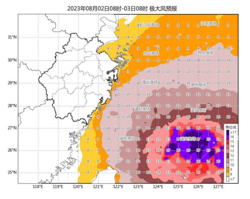
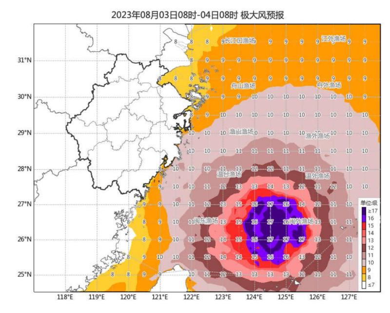
Strong wind forecast: Affected by Typhoon Kanu, there will be gusts of 13 to 15 levels in the central and southern waters of the East China Sea, and the nearby waters passed by the typhoon center can reach 17 levels or above; On May 6th, the northern waters of the East China Sea were on a scale of 11-14, and the nearby waters where the typhoon center passed through were on a scale of 15-16. The maximum gusts on the coastal waters of our province today are 8-10 levels, and tomorrow and the day after tomorrow (3-4 days, 9-11 levels; there will also be 6-8 levels of gusts in the coastal areas on the 3rd).
Rainfall forecast: under the influence of the "Kanu" peripheral circulation, there will be moderate to heavy rain and local rainstorm in the central and northern coastal areas of our province in the next three days, with the cumulative rainfall of 30~60mm, 80~120mm locally, and more than 150mm in some cases; Other areas are mainly cloudy, with scattered thunderstorms in the afternoon and short-time rainstorm in some areas with thunderstorms.
Meteorological experts say that after entering the East China Sea, "Kanu" will move slowly, and the sea area in the East China Sea will continue to experience strong winds and waves for about 5 days, with sustained strong winds along the coast of our province for about 3 days. In addition, "Kanu" gyrates less in the East China Sea. Due to the influence of its peripheral cloud system, there are local heavy rains in our province, especially in coastal areas, it is necessary to prevent the possible secondary disasters caused by the local short-term rainstorm brought by the easterly jet stream.
Zhejiang Province's typhoon prevention index has upgraded emergency response to level III for typhoon prevention
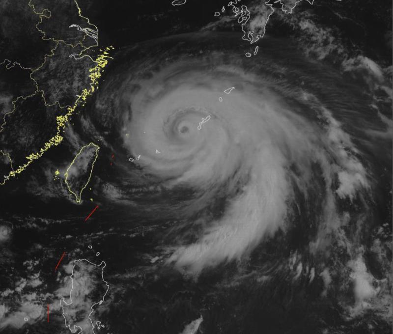
Typhoon Kanu, the 6th typhoon of this year, was located at 8:00 am today on the ocean about 610 kilometers southeast of Yuhuan City, Taizhou, China. The maximum wind force near the center was 16. It is expected to move towards the northwest direction at a speed of 10-15 kilometers per hour, and the intensity will also increase. The maximum possibility is to turn northeast in the southern coastal area of our province from the night of the 3rd to the morning of the 4th, but there is still a possibility of moving northward or landing on the coast of our province. The Provincial Meteorological Observatory has issued a typhoon warning for the sea at 9:00 am today.
According to the Emergency Plan for Flood Control, Typhoon Prevention, and Drought Relief in Zhejiang Province, the Provincial Flood Control Bureau has decided to upgrade the emergency response for typhoon prevention to Level III at 12:00 on August 2. Please closely monitor the development and changes of typhoons in various regions and departments, and do a good job in typhoon prevention according to emergency plans and work plans.


