NASA's latest satellite image: Canadian wildfire smoke has drifted to Europe, USA | Wildfire | Canada
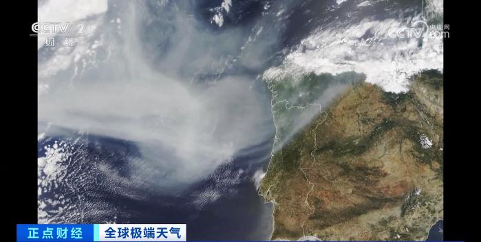
In recent times, due to the "most severe" wildfires in Canadian history, air pollution has been severe in many parts of Canada and the United States, and the scope of this impact is still expanding. According to the Associated Press, the latest satellite images from NASA show that smoke from wildfires in northern Quebec, Canada has drifted across the sea to parts of Europe.
Satellite images released by NASA on July 3 show that the haze generated by wildfires in northern Quebec, Canada has crossed the North Atlantic and spread to parts of the Iberian Peninsula and Western Europe.
Canadian officials have stated that Canada is experiencing the worst wildfire season in its history. As long as wildfires continue to burn, air quality throughout the summer will be a serious problem. Officials from the Fire and Environment Department stated that due to the drier climate this year, wildfires started earlier and spread more rapidly than usual, depleting fire resources across Canada.
The latest data released by the Canadian Interdepartmental Forest Fire Center on June 29th shows that there have been over 3000 wildfires across Canada this year. Currently, there are still about 490 wildfires in the country, of which 255 are in a state of loss of control. According to reports, wildfires have occurred in almost every province of Canada. According to data from the Canadian government, the area of wildfires has reached a record breaking 30000 square miles, almost as large as Chongqing in China.

Wildfire incidents are frequent in Canada. According to data from the Canadian Department of Natural Resources, there have been an average of 7300 wildfires per year in Canada over the past 25 years, with an average area of approximately 25000 square kilometers. It is estimated that wildfires in Canada have released 160 million tons of carbon dioxide into the atmosphere this year, exceeding one tenth of the total carbon emissions caused by wildfires worldwide in 2022.


