Kanu is approaching! From the night of the 10th day to the day of the 12th day, the local rainstorm in Harbin precipitation | process | Kanu
The Municipal Meteorological Observatory reminds that the night of the 10th to the day of the 12th will be the main precipitation period for "Kanu", and this precipitation process will cause high meteorological risks of secondary disasters. Please pay attention to prevention.
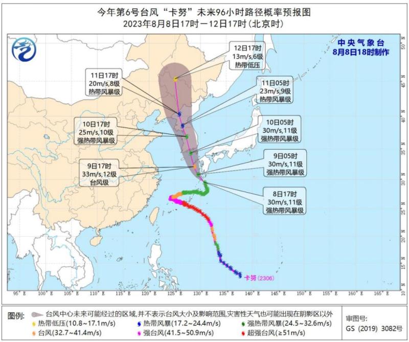
The center of Typhoon Kanu, the 6th typhoon of this year, was about 225 kilometers south of Kagoshima, Japan at 5:00 pm on the 8th. The maximum wind force near the center was 11. Kanu is moving northwest at a speed of about 15 kilometers per hour and is expected to make landfall along the southern coast of South Korea on the morning of August 10th. It will enter the northeast region of China on the night of August 11th and gradually weaken and transform into an extratropical cyclone.
Probability forecast map of the future 96 hour path of Typhoon "Kanu" No. 6 in 2023
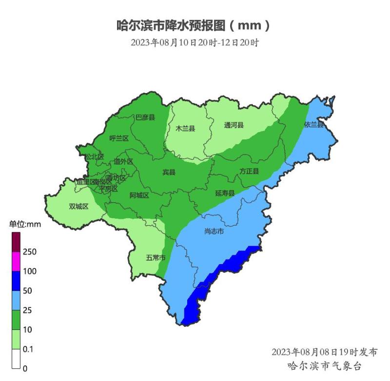
It is expected that the night of the 10th to the day of the 12th will be the main precipitation period for "Kanu". The main urban area, Hulan, Shuangcheng, Acheng, Bayan, Mulan, Bin County, Tonghe, Yilan West, Fangzheng West, Yanshou West, Shangzhi West, and Wuchang West will have a cumulative precipitation of 10-25 millimeters. The cumulative precipitation in Wuchang East, Shangzhi East, Yanshou East, Fangzheng East, and Yilan East will be 25-50 millimeters, with local areas in Wuchang East and Shangzhi Southeast reaching 50-90 millimeters. The rainfall is accompanied by short-term heavy rainfall, thunderstorms, strong winds, small hail, and other severe convective weather. The maximum hourly rainfall is 30-50 millimeters, with gusts of 7-8 levels and locally 9-10 levels in the southeast.
Precipitation forecast chart from 20:00 on August 10, 2023 to 20:00 on August 12, 2023
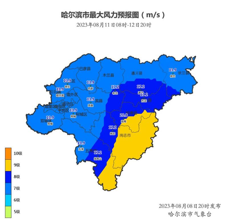
Forecast chart for gusts above level 7 from 08:00 to 20:00 on August 11, 2023
The reporter learned from the Municipal Meteorological Observatory that this rainfall process coincides with the strong rainfall in the southeastern region from August 2-4. Currently, the soil in the southeastern region is saturated or close to saturation, and this precipitation process has a high meteorological risk of secondary disasters. Attention should be paid to areas with heavy rainfall. Heavy rainfall can easily cause the water level of small and medium-sized rivers to rise, leading to higher meteorological risks of secondary disasters such as flash floods, geological disasters, and floods in small and medium-sized rivers. It is recommended to strengthen the investigation of disaster hazard points.
To prevent disasters such as urban waterlogging, tunnel and culvert waterlogging, and agricultural waterlogging, it is necessary to strengthen field management, do a good job in drainage and waterlogging prevention in low-lying and easily waterlogged areas, and ensure safety management in civil transportation.
At night, the temperature drops and the humidity is high, making it prone to heavy fog and low visibility, which may affect the safety of emergency rescue and mass transfer work. People and rescue personnel in areas with heavy flood conditions should pay attention to keeping warm, avoid catching a cold, and prepare rainproof tools.
In windy weather, it is necessary to prevent the collapse of buildings such as sheds and billboards caused by strong winds, as well as the impact on high-altitude operations, water operations, and navigation. At the same time, strong winds can have an impact on reservoir dams and river embankment protection, which requires special attention.


