Kanu is about to enter the East China Sea! Or take a sharp turn! After being stranded, it is not ruled out that the wind will directly rush towards the coastal areas of central Zhejiang to northern Fujian. | Sea | East China Sea
Central Meteorological Observatory at 06:00 on August 2nd
Continue to issue a blue typhoon warning:
The 6th typhoon of this year
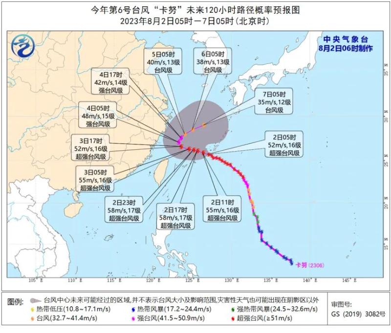
The center of Kanu
At 5:00 am on the 2nd
To the southeast of Yuhuan City, Zhejiang Province
On the northwest Pacific Ocean, approximately 630 kilometers away,
It's 25.7 degrees north latitude and 127.0 degrees east longitude,
The maximum wind speed near the center is 16 levels,
The minimum central air pressure is 935 hPa,
The radius of the seventh level wind circle is 300-360 kilometers,
The radius of the tenth level wind circle is 140 kilometers,
The radius of the twelve level wind circle is 90 kilometers.
It is expected that "Kanu" will move towards the northwest direction at a speed of 10-15 kilometers per hour, and its intensity will also increase. It will soon enter the East China Sea and gradually approach the coastal areas of central Zhejiang to northern Fujian.
Gale forecast: From 08:00 on August 2nd to 08:00 on August 3rd, there will be strong winds of force 6-8 and gusts of force 9-10 in the Bashi Strait, the waters east of Taiwan, most of the East China Sea, and the waters near the Diaoyu Islands, as well as in the Hangzhou Bay, Zhejiang coastal areas, northern coastal areas of Fujian, northern and southern coastal areas of Taiwan Island. The wind speed in the southern part of the East China Sea can reach force 9-12 and gusts of force 13-14, while the wind speed in the nearby waters passing through the "Kanu" center can reach force 13-17 and gusts of force 17 or above.
Precipitation forecast: From 08:00 on August 2nd to 08:00 on August 3rd, there will be heavy rain in the northern part of Taiwan Island.
Expert interpretation
Typhoon Kanu will enter the East China Sea,
Will it land in our country?
Is it difficult to predict the Kanu path? Will it land in our country? Will it have an impact on the East China region? The China Meteorological Daily reporter interviewed Dong Lin, the chief forecaster of the Central Weather Observatory, on a topic of public concern.
Moving at a speed equivalent to the speed of a bicycle, "Kanu" will enter the East China Sea on August 2nd
On the early morning of July 28th, "Kanu" was officially numbered. Prior to this, "Kanu" had been used as the name of a typhoon three times.
From the Fengyun 4B nebula map, the organizational structure of "Kanu" is symmetrical, and the eye area is clearly visible. The convective cloud system near the center of the typhoon is developing vigorously. Monitoring data shows that at 17:00 on August 1st, the "Kanu" center was located in the northwest Pacific Ocean, approximately 780 kilometers southeast of Yuhuan City, Zhejiang Province. The maximum wind force near the center was 16 levels, and the lowest central pressure was 935 hPa.
Kanu, a tall man, is also a slow paced person. With the weakening of the guiding airflow, it is expected that "Kanu" will move northwest at a speed of 15 to 20 kilometers per hour, with increased intensity. It will enter the East China Sea on the morning of August 2, gradually approaching the coastal areas of central Zhejiang and northern Fujian.
Dong Lin reminds that although rainfall in North China has significantly decreased, it is still necessary to remain highly vigilant against secondary disasters such as flash floods. At the same time, the rain will increase and decrease. From the night of the first day to the fourth day, there will be heavy to rainstorm and local heavy rainstorm in the northeast of Inner Mongolia, the south of Heilongjiang, Jilin, and the central and northern Liaoning. The above areas are accompanied by short-term heavy rainfall, thunderstorms, gales, hail and other severe convective weather. At the same time, attention should be paid to the possibility of tornadoes. It is suggested that the northeast should take precautions in advance.
The Central Meteorological Observatory predicts that as Typhoon Kanu gradually approaches the eastern waters of China, from 20:00 on August 1st to 20:00 on August 2nd, there will be strong winds of force 7 to 8 and gusts of force 9 to 10 in the southern waters of the East China Sea, the ocean east of Taiwan, the Bashi Strait, the coastal waters of Zhejiang, and coastal areas. Some areas in the southeastern part of the East China Sea will have winds of force 9 to 12 and gusts of force 13 to 14; Among them, the nearby sea area where the "Kanu" center passes can have wind speeds of 13 to 16 levels, gusts of 17 levels or above.
Due to the comprehensive influence of multiple factors, the "Kanu" forecast has high complexity and uncertainty
Compared to the previous forecast path, there has been a significant adjustment in the current path of "Kanu". Dong Lin explained that in the early stage, the band like subtropical high pressure on the north side of "Kanu" was strong and stable, so "Kanu" was mainly guided by the north side subtropical high pressure to move towards the northwest direction. But with the weakening of the subtropical high pressure on the north side and the eastward retreat of the fault, the weak guiding atmosphere slows down the typhoon's movement, and even stops and rotates in place. At the same time, the thermal conditions in the waters near Kanu are good, which is conducive to the sustained strengthening of typhoon intensity.
After Kanu moves into the East China Sea on the 2nd, its path complexity and uncertainty will further increase. Currently, there are still significant differences in the prediction of the Kanu path and intensity among multiple numerical forecasting models worldwide.
Dong Lin said that the changes in the subtropical high pressure and the oscillation of the southwest monsoon trough will cause significant variables in the movement path of "Kanu". In such a complex situation, the subtropical high pressure on both sides of the north and south will undergo changes. The guiding role of the subtropical high pressure on the north side will decrease, while the role of the subtropical high pressure and monsoon on the south side will increase. Typhoons may shift from the northwest to the northeast direction; In addition, there are high-altitude cold eddies on both sides of "Kanu", which makes the impact system more complex and variable. Therefore, the possibility of "Kanu" landing along the Zhejiang Fujian coast cannot be ruled out.
At present, it appears that "Kanu" is expected to turn northeast near the southern coast of Zhejiang on the 4th, with the most likely turning to Japan and South Korea after being stranded in the East China Sea for a while. However, it is not ruled out that after being stranded, it may directly rush towards the central coast of Zhejiang to the northern coast of Fujian, or turn back to the East China Sea near the eastern coast of China after landing in Japan and South Korea.
Dong Lin suggests that the public in East China should continue to pay attention to the latest news of the typhoon. Regardless of whether Kanu makes landfall or not, it will be close to the east coast of China, bringing continuous waves and wind and rain to the East China Sea area.
Typhoon Kanu may experience a sharp turn in its direction
Typhoon Kanu, the 6th typhoon of this year, is developing and will move into the East China Sea this morning, gradually approaching the coastal areas from central Zhejiang to northern Fujian. Afterwards, it may make a sharp turn and move towards the northeast direction. What is the reason for this strange movement?
West Lake Music Fountain Pauses Spray
Restore after the typhoon warning is lifted

The reporter learned from the West Lake Scenic Area that, according to the meteorological warning and the spirit of the provincial and municipal flood and typhoon prevention meetings, the West Lake Music Fountain will be suspended from spraying starting from August 1st, and will resume spraying after the typhoon warning is lifted.
Qianhang cruise ship suspended operation
Due to factors such as typhoons and upstream flood discharge, in order to ensure the safety of tourist life and property as well as ship operation, cruise ships need to anchor in the upstream anchorage in advance to prevent typhoon and avoid typhoon. The Qianhang cruise ship has launched an emergency plan to defend against typhoons. The operation of the cruise ship will be suspended from July 31, 2023, and the resumption of operation will depend on the situation of typhoons and tides.
I have purchased a ship ticket during the typhoon shutdown period for extension or refund processing. Service consultation hotline: 0571-851781970571-85120809.
Under the influence of "Kanu", waves and storm surges
Warning dual upgrade
Affected by the "Kanu", the waves in the waters of Zhejiang Province have gradually increased. According to the latest warning from the Zhejiang Provincial Marine Monitoring and Forecasting Center at 16:00 yesterday, both wave and storm surge warnings have been upgraded, with wave warnings upgraded to orange and storm surge warnings upgraded to yellow.
At present, a maximum of 2.8 meters of waves have appeared in the waters off Zhejiang, including 1.5 meters in Zhujiajian, 2.3 meters in Shengsi Shengshan, 1.5 meters in Dachen, 1.8 meters in Nanji, 2.8 meters off Zhoushan, and 2.3 meters off Wenzhou. According to the prediction of the Central Meteorological Observatory, "Kanu" will move into the East China Sea this morning, and the waves and storm surge will further increase.
On the evening of July 31st, high tide levels exceeding the local blue alert level appeared at Zhenhai Station and Jintang Station.
Affected by Typhoon Kanu, the 6th typhoon of this year, it is expected to:
Offshore waters: Hangzhou Bay has medium to large waves ranging from 1.4 to 2.2 meters, which increased to 2.0 to 3.0 meters this evening; In northern Zhejiang, there are waves ranging from 3.0 to 4.0 meters in size, and this evening they have increased to waves ranging from 4.0 to 6.0 meters in size; There are huge waves ranging from 3.0 to 4.5 meters in central Zhejiang, which have increased to 6.0 to 8.0 meters this evening; In the southern part of Zhejiang, there are waves ranging from 3.5 meters to 5.0 meters, and this evening they have increased to wild waves ranging from 7.0 meters to 9.0 meters.
The wave warning level for nearshore waters is orange.
Near shore waters: Jiaxing has light to moderate waves ranging from 0.5 to 1.0 meters, which increased to 1.2 to 2.0 meters this evening; Zhoushan and Ningbo have medium to large waves ranging from 1.6 to 2.5 meters, which have increased to large waves ranging from 2.5 to 3.5 meters this evening; Taizhou and Wenzhou have medium to large waves ranging from 1.6 to 2.5 meters, which have increased to large to huge waves ranging from 3.0 to 4.0 meters this evening.
The wave warning level for nearshore waters is yellow.
Affected by Typhoon Kanu, the 6th typhoon of this year, it is expected that by tomorrow night, there will be a storm surge of 30-60 centimeters along the coasts of Jiaxing, Zhoushan, Ningbo, Taizhou, and Wenzhou. The storm surge warning level for Zhoushan, Ningbo, and Wenzhou cities is yellow, while the storm surge warning level for Jiaxing and Taizhou cities is blue.
Zhejiang Weather Reminder
Key focus
After entering the East China Sea, Typhoon Kanu moves slowly and will continue to experience strong winds and waves for a long time. There will also be sustained strong winds along the coast of our province this evening, and we need to strengthen our prevention measures.
"Kanu" rotates less in the East China Sea. Due to the influence of its peripheral cloud system, there is local heavy rainfall in the capital of our province. In the early stage, affected by "Dusurai", the disaster bearing bodies in coastal areas and other areas are vulnerable, so attention should be paid to preventing possible secondary disasters caused by short-term rainstorm.
At present, the subtropical high pressure system is still undergoing further adjustment, and there is still uncertainty in the later stage of the "Kanu" typhoon path. If it makes landfall in our province or moves northward along the coast, it will have a greater impact on the wind and rain in our province. Relevant regions should prepare for typhoon defense as soon as possible.
Taizhou Meteorological Observatory at 20:40 on August 1st
Issuing a coastal sea surface gale warning:
Affected by Typhoon Kanu, the wind force on the coastal waters of our city is gradually increasing. It is expected that there will be a level 8 strong wind this morning, and the wind force will gradually increase from level 7-9 to level 8-10 from this afternoon to night. Please pay attention to preventing the adverse effects of strong winds on maritime transportation, facility agriculture, and construction projects. At present, yellow warning signals for strong winds have been issued in Luqiao, Jiaojiang, Yuhuan, and Wenling.
News+
How powerful is a typhoon when it encounters an astronomical high tide period?
On August 1st, the southeastern coast of China entered an astronomical high tide period.
"Astronomical tides are tidal phenomena generated by the tidal forces of the moon and the sun in the Earth's ocean." said Che Zhumeng, Deputy Director of the Zhejiang Ocean Monitoring and Forecasting Center. When the two tidal zones of the moon and the sun coincide at the same time, an astronomical spring tide is formed. Currently, the coastal areas of Zhejiang are in the astronomical spring tide period.
Astronomical tides are normal astronomical phenomena and generally do not cause disasters. But when encountering a typhoon, its impact will have to be another matter.
In fact, the probability of typhoons encountering astronomical tides is not small. "Usually within a month, there are about 10 days of astronomical high tide periods. Once a typhoon is active, it means there is a one-third chance that the two will meet," said Che Zhumei.
Not all periods of astronomical high tide are at high levels. "Based on our current analysis, there will be obvious high tide levels around noon and midnight in the near future, while other times it will be at low tide levels." Che Zhumei said that if a typhoon makes landfall during low tide periods, the impact it can cause is actually limited.
However, once a typhoon makes landfall at the peak of the astronomical high tide period, the two will "work together" and the "three encounters" of wind and rain will occur.
On September 14, 2022, Typhoon "Meihua" coincided with an astronomical tide, causing huge waves along the coast of Wenling, Zhejiang. The "three meeting" of the storm surge in the picture refers to the astronomical tide flood, the rainstorm brought by the typhoon and the waves caused by the strong wind of the typhoon. With the constantly rising tide level, in addition to the possibility of being submerged, coastal low-lying areas will also experience the phenomenon of seawater backflow.
"Be wary of the phenomenon of wind, rain, and tide 'three encounters'." Che Zhumagnesium reminds that in recent times, the waters in Zhejiang Province are prone to strong winds and waves, and it is recommended to postpone maritime travel and coastal tourism. In addition, today's astronomical tides in coastal areas such as Daishan County, Dinghai District, Putuo District, Cixi City, and Yongjia County will approach or exceed the high tide level of the local blue warning tide. Relevant departments need to prepare for defense in advance.


