Just upgraded to a strong typhoon, significant change! The Great Adjustment of the "Kanu" Path Hebei | Henan | Kanu
After Typhoon "Dussuri"
Kanu takes over
Now look at "Kanu"

Is it like turning around in the East China Sea?
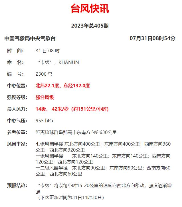
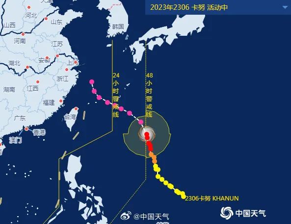
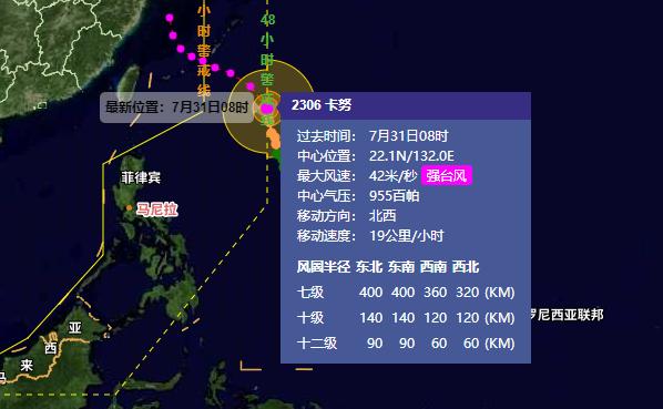
According to the latest news from the Central Meteorological Observatory, Typhoon Kanu has upgraded to a strong typhoon at 8:00 pm today. Maximum wind speed: 14 levels, 42 meters per second. Central pressure: 955 hPa. Reference location: Approximately 630 kilometers southeast of Naha City in the Ryukyu Islands. Kanu will move towards the northwest at a speed of 15-20 kilometers per hour, gradually increasing in intensity.
Whether making landfall or heading north, Typhoon "Kanu" will inevitably bring significant wind and rain to Zhejiang in early August, with the main impact period from the 2nd to the 4th. Please pay further attention to relevant forecast and warning information and prepare in advance.
Central Meteorological Observatory at 06:00 on July 31st
Continue to issue rainstorm red warning
Since July 29, heavy to rainstorm has occurred in central and southern Hebei, eastern Hebei, most of Beijing, Tianjin, central and eastern Shanxi, most of Henan, central and western Shandong, and the northern part of the peninsula. heavy rainstorm has occurred in parts of central and southern Beijing, central and southern Hebei, northeastern Hebei, northern Henan, eastern Shanxi, and western Shandong, and in parts of central and southern Hebei, southwest Beijing, and northern Henan. The maximum hourly rainfall intensity in most regions is 20 to 50 mm, and the local area exceeds 80 mm.
It is estimated that from 08:00 on July 31 to 08:00 on August 1, there will be heavy to rainstorm in most of Hebei, Beijing, Tianjin, eastern Shanxi and other places, among which, there will be heavy rainstorm in some areas in central Hebei, central and western Beijing and other places; Scattered heavy rain or rainstorm occurs in the south central Inner Mongolia, northern Henan, northern Jiangxi, northeastern Yunnan, southern Sichuan, northwestern Guizhou, coastal areas in southern Guangxi, and southwestern Hainan Island. Some areas mentioned above have short-term heavy rainfall, and locally there are strong convective weather such as thunderstorms and strong winds.
Defense Guidelines:
1. The government and relevant departments shall do a good job in emergency and rescue work against rainstorm according to their responsibilities;