Is it still possible to have a "comeback"?, Kanu Turning Typhoon | High Pressure | Kanu
According to the Central Meteorological Observatory at 6:00 am on August 4th
Strong Typhoon "Kanu" Still on the Sea in the Southern East Sea
But this morning it will stop spinning and start turning
Moving towards the northeast at a speed of 5-10 kilometers per hour
Expected to move out of the East China Sea on the morning of the 6th
Trending towards the ocean south of Japan, the intensity slowly weakens.
The movement of Typhoon Kanu, the 6th typhoon of this year, is really surprising. According to the latest real-time path forecast, it is about to make a magnificent turn.
On August 4th at 06:00, the Central Meteorological Observatory continued to issue a blue typhoon warning:
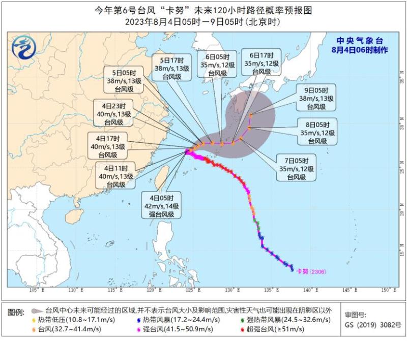
The center of Typhoon Kanu, the 6th typhoon of this year, was still located at 5 o'clock this morning on the sea surface of the eastern Hainan Sea, about 330 kilometers southeast of Yuhuan City, Zhejiang Province. It is 26.8 degrees north latitude and 124.2 degrees east longitude. The maximum wind force near the center is 14, and the minimum pressure at the center is 955 hPa. The radius of the 7th level wind circle is 360 kilometers, the radius of the 10th level wind circle is 170-190 kilometers, and the radius of the 12th level wind circle is 100 kilometers.
It is expected that "Kanu" will stop circling this morning and begin moving towards the northeast direction at a speed of 5-10 kilometers per hour. It will move out of the East China Sea on the morning of the 6th and move towards the ocean south of Japan, with its strength slowly weakening.
Since its formation in the ocean east of the Philippines on July 27th, "Kanu" has successfully gained attention with its "magical displacement".
Regarding the "demonic displacement" of "Kanu", some say it is blessed by a "mysterious force", while others say that this "mysterious force" is a subtropical high pressure... So, does "mysterious force" exist? Is it a subtropical high pressure?
Firstly, we need to first sort out the "growth history" of "Kanu".
On July 27th, Kanu was born in the ocean east of the Philippines. At first, it didn't feel anything special about itself. While absorbing nutrients on the warm ocean surface, it continued to grow and move towards the northwest, which is also the "life direction" of most typhoons.
If there were no accidents, "Kanu" would come all the way towards the coast of Zhejiang, and finally choose to "land" in Zhejiang.
On July 31st, the slowly growing "Kanu" entered a "rebellious period". On one hand, he stepped on the "emergency brake" and the movement speed slowed down significantly, while on the other hand, he began to show the idea of adjusting towards the north and heading north near the sea.
On August 2nd, "Kanu" entered the East China Sea and, in a series of "magic circles", fell into a period of confusion in life: where is the way out in the vast ocean?
On August 4th, after careful consideration, "Kanu" finally "awakened" and will turn around and leave with the resolute determination of "the prodigal son returns without exchanging money".
So, at every turning point in the growth of "Kanu", who is "guiding the way" for it? The subtropical high pressure system must have a name.
The movement of typhoons is mainly influenced by the guiding airflow of the periphery of the subtropical high pressure, especially when the subtropical high pressure is relatively stable and forms an east-west band. Low latitude typhoons generally move in a northwest direction along the south side of the subtropical high pressure.
Unfortunately, Kanu caught up with the emotional fluctuations of the subtropical high pressure system.
When the emotions of the subtropical high pressure fluctuate, it usually breaks or retreats eastward and southward, and the typhoon's movement path will also adjust, turning towards the north or northeast direction.
Unfortunately, the emotional fluctuations of the subtropical high pressure this time are quite significant. From the initial east-west strip to a circular shape, the "Kanu" is surrounded from three directions: north, east, and south.
Among them, the northern subtropical high pressure guides it westward, the southern subtropical high pressure pulls it eastward, and the eastern subtropical high pressure pulls it northward.
The complex guiding airflow is like a tug of war, pulling the "Kanu" in different directions. Kanu, who only comes out for a stroll once a year, has never seen this posture before, so he has a "magic circle".
From the night of August 3rd to the day of August 4th, the subtropical high finally remembered that it was still responsible for guiding "Kanu" and broke, then retreated southward, opening a turning channel for "Kanu".
The subtropical high pressure has fractured into two blocks, northwest and southeast. The high pressure in the northwest blocks the further westward movement of the "Kanu", while the westward airflow on the north side of the high pressure in the southeast guides the "Kanu" to move in an east-north direction.
Is the subtropical high pressure really the mysterious force behind the "Kanu"? Why does it change from a strip to a circular shape in a good state? Why would it suddenly break?

"When the subtropical high pressure develops southward, there happens to be an equatorial anticyclone near the equator, which is also a high-pressure circulation. The two 'work together' to trap 'Kanu' in the middle," said Xue Guoqiang, a senior engineer at the Ningbo Meteorological Observatory.
The equatorial anticyclone is not the only one causing trouble.
Xue Guoqiang said that the subtropical high pressure system on the north side is already in a weakened state, coupled with the influence of the westerly trough, and "sufficiently strong typhoons themselves will also have a squeezing effect on the subtropical high pressure system," ultimately leading to the rupture of the subtropical high pressure system.
The balance of the three legged system was suddenly disrupted, with the subtropical high pressure on the southeast side having relatively strong strength and occupying the main guiding position, leading the "Kanu" towards the northeast direction.
The turning point of Kanu is near 124 ° east longitude. However, this turn is not as sharp and straightforward as people imagine, but rather like a car turning around, there will be a "deceleration" process, which is also the reason for the "less movement in place" in the forecast.
Xue Guoqiang said that in fact, typhoon paths that first travel northwest and then turn northeast are quite common, mainly due to the relay effect of subtropical high pressure and westerly trough.
This time, although Kanu also turned northeast, it was the result of the action of the subtropical high pressure on the south side, which is relatively rare.
This evolution of the annular subtropical high pressure, especially the addition of the southern equatorial anticyclone, is also one of the reasons for the significant adjustment of the previous path forecast.
Is it still possible to have a "comeback"?
It seems that the overall situation of the "Kanu" sharp turn has been determined, but is it still possible for it to have a "rebound" and head straight towards Zhejiang? After all, there have been cases in the past where typhoons have been moving in a "enchanting" manner and eventually caught off guard.
In fact, this probability is gradually decreasing. However, meteorological experts analyze that in addition to the guidance of external forces, the internal driving force of "Kanu" is heading northwest. Due to its large volume, "Kanu" may also rely on inertia to move westward before turning, and the turning point is relatively close to the coast of our province.
From yesterday's daytime cloud map, it can be seen that some of the outer cloud system of "Kanu" has already been thrown to the coastal areas of Zhejiang and the northern part of Taiwan Island.
Be wary of the impact of wind and rain
According to the Central Meteorological Observatory at 16:00 on August 3rd

Affected by "Kanu", from the 4th to the 5th
Zhejiang Coastal, Taiwan Island, and East China Sea Area
There will be strong winds and rain
Although the possibility of landing in Zhejiang is decreasing
But due to "Kanu" staying in the East China Sea for a long time
Still be wary of the impact of wind and rain


