How to view the Qinghai Tibet Plateau changing from "high cold" to "wet warm"? Earth | Plateau | Qinghai Tibet Plateau
In May 2023, China's Everest scientific expedition team members once again climbed to the top of the earth to carry out scientific investigation and research. As the "roof of the world", "the third pole of the earth" and "Asian water tower", this plateau has a profound impact on the climate change of the whole country, Asia and even the whole world. However, various studies have shown that our Qinghai Tibet Plateau is changing from "cold" to "warm and wet".
"High cold" "Asian water tower"
The Qinghai-Tibet Plateau has a resounding title, called "Roof of the World", because it is the highest plateau in the world, but the Qinghai-Tibet Plateau is not born tall.
About 0.1 billion years ago, the plate carrying the Indian continent began to separate from the Antarctic plate and moved northward to the Asian continent; between 5500 and 45 million, the Indian plate collided with the Asian continent, which lasted for thousands of years. It gave the Himalayas and the Qinghai-Tibet Plateau an opportunity to "grow taller.
Up to now, the Indian Ocean plate is still squeezing the Asia-Europe plate, making the Himalayas on the plate boundary continue to rise, becoming the highest mountain range on the earth today, and thus changing the landscape pattern of Asia and shaping the current South and Southeast Asian monsoon climate pattern.
What you may not have thought is that the Qinghai-Tibet Plateau is still a real "young man"-it is one of the "youngest" plateaus in the world, always active in the forefront of crustal movement, and the edge of the Qinghai-Tibet Plateau is still rising.
On December 8, 2020, China and Nepal jointly announced that the latest elevation of Mount Everest is 8848.86 meters, which is the most accurate elevation measurement result of Mount Everest in history.
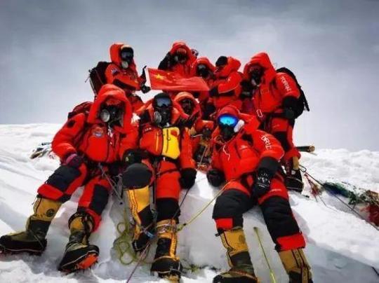
On May 27, 2020, 13 Everest scientific expedition members successfully reached the summit of Mount Everest and took a photo with the national flag. Photo In addition to the roof of the world, another title of the Qinghai-Tibet Plateau is also widely known, that is, "Asian Water Tower".
You may wonder how it can become an "Asian water tower" when it is so high and cold here. Yes, the seemingly mysterious "high and cold" plateau is the real "water town" in Asia ".
In fact, it can become a water town because the Qinghai-Tibet Plateau has unique conditions.
The first is that in the process of plateau uplift, plates are constantly squeezing and colliding with each other, forming many fault zones. Due to the uneven mountains, this creates basic conditions for the formation of lakes.
The second is that the Qinghai-Tibet Plateau is the region with the largest ice and snow reserves except the North and South Poles. There are extensive solid water bodies such as glaciers, snow, and permafrost.
With the blessing of melting ice and snow and precipitation, it has the largest number of lakes in China, accounting for half of the total area of lakes in China.
The results of the second comprehensive scientific survey of the Qinghai-Tibet Plateau in 2021 showed that there are 1400 lakes with an area of more than 1 square kilometer, with a total area of about 50000 square kilometers. The amount of fresh water evaporated alone reaches 51.7 billion tons per year, equivalent to the amount of water in 3570 Hangzhou West Lakes.
Plateau lakes are not only numerous, but also have their own charm.
Among the many lakes on the plateau, there are not only the largest lake in my country-Qinghai Lake; the lake with the largest water volume-Namtso; the second largest saltwater lake-Sellincuo; there are also Chaka Salt Lake, Yangzhuoyongcuo, etc. These blue "eyes" have attracted tourists from all over the world.
Of course, the Qinghai-Tibet Plateau is by no means a flower shelf. Due to its high topography, under the action of topography and gravity, water continuously flows out of the plateau, giving birth to our mother rivers-the Yangtze River, the Yellow River, and other major rivers in Asia, providing reliable water sources for nearly 2 billion people.
It not only shapes the topography of Asia, but also has a profound impact on the climate of Asia and the world. Without its nurturing, the brilliant human civilization in the river basins of East Asia, South Asia and Central Asia could not be born, so it is known as the "Asian Water Tower.
"High cold" becomes "warm and wet"
Water towers like the "Asian Water Tower" are distributed all over the world, and they play a pivotal role in the global water cycle. Among them, the Qinghai-Tibet Plateau looks the most magnificent. Among the 78 water tower units in the world, the Qinghai-Tibet Plateau has taken 16 and has the most important position. But at the same time, it is also the most vulnerable.

Over the past 50 years, the Qinghai-Tibet Plateau has been one of the regions with the strongest global warming. From 1961 to 2020, the annual average temperature rise here reached 0.35 degrees Celsius/10 years, more than twice the global warming rate during the same period. Rapid warming has led to an increase in precipitation and accelerated melting of glaciers and permafrost, making the plateau warmer and wetter and the lake area has expanded significantly.
△ The waters of the Zerin fault have increased significantly. Photo Data from the National Climate Center show that the annual precipitation on the Qinghai-Tibet Plateau showed an increasing trend from 1981 to 2020, with an average increase of 14mm every 10 years. From 2000 to 2020, the overall water area of lakes on the Qinghai-Tibet Plateau continued to increase, reaching 70304.5 square kilometers in 2020. More than 80% of the lakes are expanding, and the central and northern lakes are expanding more obviously.
The latest research by the Institute of Atmospheric Physics of the Chinese Academy of Sciences also pointed out that from 2002 to 2018, the lake water reserves of 18 large lakes in the inner flow area of the Qinghai-Tibet Plateau increased at a rate of about 26.92mm/year. Due to the difference of regional change rate, the area of Sellincuo Lake exceeded Namtso in 2014, becoming the second largest saltwater lake in China.
It is particularly noteworthy that this warm and wet trend has been consistent over the past two millennia.
And this is just the "tip of the iceberg" of the Qinghai-Tibet Plateau affected by global warming ".
Take what to save you
My glaciers and permafrost
While becoming "watery," the area of glaciers and permafrost on the Qinghai-Tibet Plateau is decreasing.
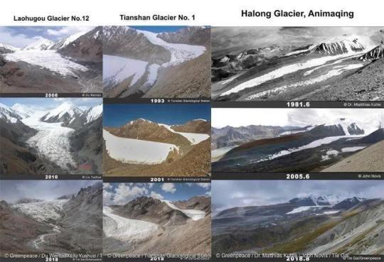
The second comprehensive scientific research on the Qinghai-Tibet Plateau found that in the past 50 years, the glacier area of the Qinghai-Tibet Plateau and its adjacent areas has retreated by 15%, and the permafrost area of the plateau has decreased by 16%. Of the 82 glaciers actually observed on the Qinghai-Tibet Plateau, 55 are in a state of retreat, with the largest loss of ice volume and area shrinkage in southeastern Tibet. Glaciers at the end of the lake retreated and thinned faster than glaciers at the end of the land. In 2020, 1019 glaciers will terminate as lakes, with a total area of 3337±10 square kilometers, accounting for 7% of the total glacier area.
Why should we care about permafrost and glaciers?
Frozen soil is often described as the earth's "natural refrigerator". It affects the water and heat exchange between the earth and the atmosphere, the surface hydrological process, the ecosystem in cold region and the stability of engineering buildings in cold region. The Qinghai-Tibet Plateau is the world's largest permafrost region in the middle and low latitudes. From 1961 to 2020, the area of permafrost decreased by 16%, affecting infrastructure construction.
Glaciers are important freshwater reserves. Due to the melting of glaciers, from 2002 to 2017, the land water reserves of the Qinghai-Tibet Plateau decreased at a rate of about 10 billion cubic meters per year. In the long run, it will bring about a water crisis for downstream residents.
Changes in glacier cover area in different years.
Glacier meltwater also transports a large number of biologically active elements and harmful elements downstream each year, affecting the primary productivity of downstream terrestrial or aquatic ecosystems, and ultimately affecting the global material cycle and feedback to the climate system.
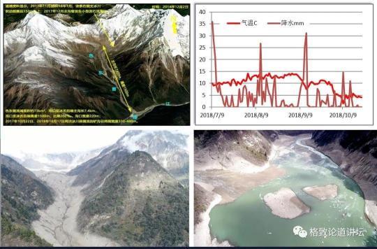
△ In 2018, an ice avalanche occurred in Dongpugou, Linzhi Jiala Village, Xizang.
At the same time, glacial melting further exacerbated the ice rock avalanche-debris flow, glacial lake outburst-flood/debris flow and other glacial disaster chain. Not only that, the rise of the lake water level and the expansion of the lake surface are not only prone to outburst, but also change the water system in the north source area of the Yangtze River, seriously threatening the lives and property safety of local residents.
In the past 10 years, there have been 5 new glacial lake outburst disasters in the Himalayas. Among them, the flood and glacier debris flow disaster on July 15, 2013 caused 14 administrative villages downstream to be affected to varying degrees, and the economic loss reached 0.2 billion yuan.
In 2018, an ice collapse occurred in Sedongpu Gully near Gara Village in the lower reaches of the Yarlung Zangbo River, causing the water level in the lower reaches of the Yarlung Zangbo River to rise by more than ten meters, posing a great threat to residents and traffic lines along the coast.
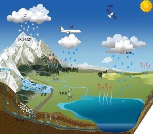
The composition of key water cycle elements in lakes on the Qinghai Tibet Plateau.
What will happen if this goes on?
It is foreseeable that if the glacial permafrost conditions on the plateau continue to deteriorate, the impact will not only be more difficult to climb Mount Everest.
The World Meteorological Organization has set a goal that by the middle of the 21st century, the global temperature will not rise by more than 2 degrees Celsius than before the industrial revolution, and it is called "moderate climate warming". In this case, the temperature of the Qinghai-Tibet Plateau will reach 4 degrees Celsius.
To make matters worse, the goal of keeping global warming below 2 degrees Celsius may be difficult to achieve.
In 2022, the World Meteorological Organization stated that the probability of global average temperature exceeding 1.5 degrees Celsius in the next five years is 50%, and this probability will increase over time.
Studies have shown that even if the global warming can be controlled below 2 degrees Celsius, by the middle of the 21st century, the net loss of water reserves on the Qinghai-Tibet Plateau may reach 230 billion cubic meters, which is about the total storage capacity of the six Three Gorges.
Another study also pointed out that under the medium emission scenario, the future increase trend of lake water reserves in the inner flow area of the Qinghai-Tibet Plateau will also slow down. By the middle of the 21st century, the growth rate of lake water reserves will drop to about 40% of the past 20 years.
Of the 16 major cities in the world that are most likely to face water shortage crisis in the future, 12 are located around the Qinghai-Tibet Plateau and in the middle and lower reaches. Significant reductions in water supply capacity and serious imbalances in water resources may even bring about other problems.
In the context of global warming, the greening of plateau vegetation and the retreat of the cryosphere will lead to a continuous decrease in the surface albedo of the plateau. This trend is expected to continue to increase in the future.
As the critical point of 1.5 degrees Celsius continues to approach, what kind of impact a continuously warming earth will have on the Qinghai-Tibet Plateau is simply unimaginable......
How the future
Depends on each of us
On June 20, 2023, the assessment report released by the International Centre for Integrated Mountain Development pointed out that if greenhouse gas emissions are not significantly reduced, 80% of the total glacier volume in the Hindu Kush Himalayan region will disappear by the end of this century-even far beyond the worst-case prediction of the United Nations Intergovernmental Panel on Climate Change.
Not only the Qinghai-Tibet Plateau, the global glacier mass loss has been accelerating in the past 20 years. From 2000 to 2019, the average annual cumulative loss of glacier mass was 267 billion tons. The impact of glacial melting is also far more than just sea level rise. The ecological imbalance of the Qinghai-Tibet Plateau under global warming is only a microcosm of the "big money" of human activities.
On April 20, 2023, UN Secretary-General Guterres warned that if countries continue to maintain current policies, global temperatures will rise by 2.8 degrees Celsius by the end of the 21st century, which will be "the world's death sentence".
If that day is destined to come, how should we adapt to this increasingly extreme world? Perhaps the button to end the "death penalty" is in the hands of each of us.


