How strong is Typhoon "Dussuri"?, The scope of influence is approaching North China!
The 5th typhoon of this year, Dussuri, is gradually approaching China. According to the meteorological department's forecast, the typhoon has a large impact range and strong intensity, and its impact area can reach as far north as North China.
How strong is "Du Suri"? How will it affect our country? On the 26th, experts from the China Meteorological Administration interpreted this.
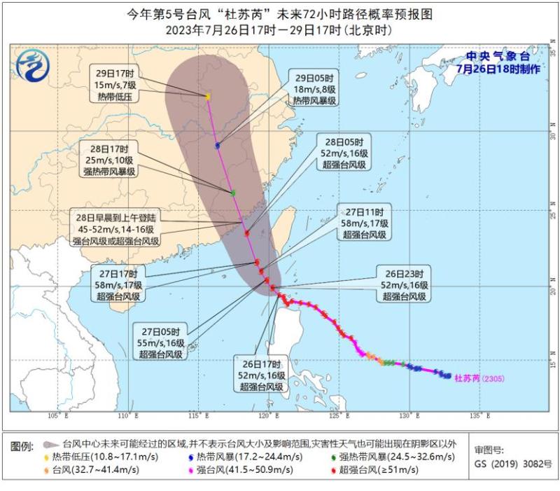
Landed on the southeast coast on the 28th
According to the meteorological department's monitoring, the center of Typhoon Du Suri, the 5th typhoon of this year, was located at 2:00 pm on the southern sea surface of the Bashi Strait, about 290 kilometers south of E Luan Bi in Taiwan Province, China. The maximum wind force near the center was 16 levels.
"Du Suri" will move towards the northwest direction at a speed of 10-15 kilometers per hour, with little change in intensity. It will move into the northeast of the South China Sea from the night of the 26th to the morning of the 27th, and gradually approach the coastal areas from Fuqing, Fujian to Huilai, Guangdong. It will make landfall in the above-mentioned coastal areas from the morning of the 28th to the morning, with the maximum possibility of landing in the coastal areas from Jinjiang, Fujian to the border between Fujian and Guangdong. The expected landing intensity is strong typhoon level, 42-48 meters/second, and 14-15 levels.
🔹 As Typhoon Dussuri approaches, there will be a significant increase in wind and rain in the southeastern coastal areas, especially in the area between Fujian and Guangdong where rainfall is strongest.
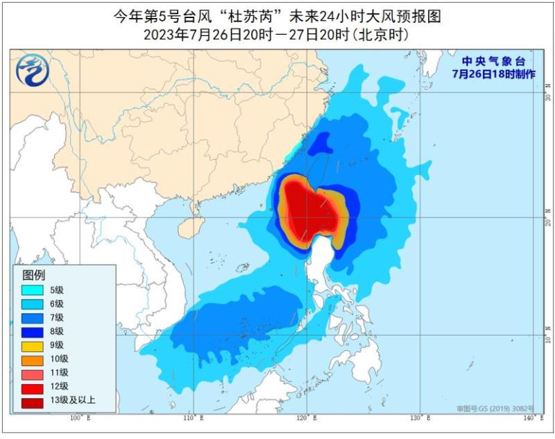
According to the forecast from the Central Weather Bureau, from the 26th to the 29th, there will be gusts of force 6-8 and strong winds of force 9-10 in the eastern waters of Taiwan, the eastern and southern parts of the East China Sea and South China Sea, the Bashi Strait, the Taiwan Strait, Taiwan Island and its coastal areas, the central and southern coasts of Fujian, and the eastern coast of Guangdong. The wind speed in the southern coastal areas of Fujian, the Bashi Strait, the northeastern part of the South China Sea, and the southern waters of the Taiwan Strait will reach force 9-12 and gusts of force 13-15. The center of the typhoon can reach wind speeds of up to 13-17 levels and gusts of up to 17 levels in the nearby waters.
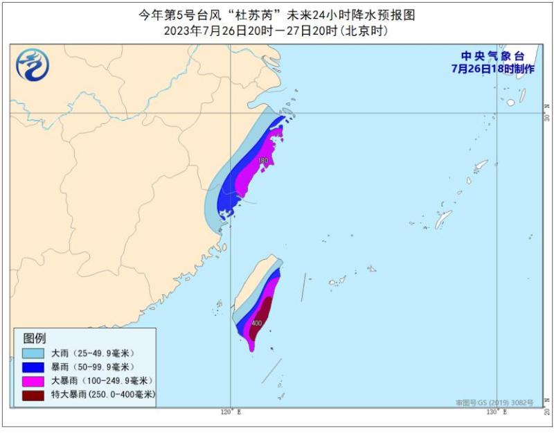
🔹 In terms of rainfall, from the 27th to the 29th, heavy to rainstorm will successively occur in Taiwan Island, eastern Zhejiang, Fujian, eastern Guangdong and coastal areas, Jiangxi, Anhui, Huang Huai River, North China and other places, including eastern and southern Taiwan Island, central and southern Fujian and eastern coastal areas, eastern Zhejiang coastal areas, eastern Guangdong and other places, and local extremely heavy rainstorm. Among them, the cumulative rainfall in the eastern and southern parts of Taiwan Island, central and southern Fujian, eastern coastal areas of Zhejiang, and eastern Guangdong can reach 150-250 millimeters, and locally 300-500 millimeters.
🔹 Is there still a variable in the intensity of login?
On the evening of the 24th, "Dussuri" strengthened to a super typhoon level, but according to meteorological departments, it may make landfall at a strong typhoon level. Why does the intensity of "Dussuri" weaken?
Zhang Ling, the chief forecaster of the Central Weather Observatory, said that during its peak hours, the intensity of "Dussuri" reached level 17 with wind speeds exceeding 60 meters per second. Currently, the intensity of "Dussuri" is level 16, and it may further weaken in the future, mainly due to the influence of the terrain of Taiwan Island. During its northward journey, it is relatively close to Taiwan Island, and the terrain of Taiwan Island may cause its intensity to decline to some extent. "On the morning of the 26th, monitoring showed that 'Dussuri' had shown a clear northward movement trend within the Bashi Strait."
Zhang Ling stated that, however, it should be considered that "Dussuri" is a relatively open sea area in the Bashi Strait. After entering the northeast of the South China Sea, the thermal energy conditions of the ocean and its own thermodynamic conditions are still good. Therefore, the intensity of this typhoon when approaching the mainland is still relatively strong, and it cannot be taken lightly.
Further analysis is needed based on the evolution of the actual situation, especially focusing on the northward path of the typhoon. If it is closer to Taiwan Island, its intensity may be slightly lower. However, if it is further away from Taiwan Island, its intensity near the mainland will be stronger. "We will also closely follow and issue rolling forecasts in the future."
Is "Du Suri" rare?
Zhang Ling stated that compared to historical typhoons, "Dussuri" is not a very rare typhoon, and it has certain similarities with "Moranti" in 2016 and "Haitang" in 2017.
Zhang Ling said that "Du Suri" and "Moranti" both passed through the Bashi Strait, then entered the southern Taiwan Strait, and then landed on Chinese mainland, but the maximum intensity of the "Moranti" typhoon reached 75 meters per second., But the maximum value of "Du Suri" in the early stage was 62 m/s, so from the peak intensity, the "Moranti" typhoon will be stronger.
In addition, when Typhoon Moranti passed through the southern part of Taiwan Island, the attenuation effect of the terrain was limited, and the core area of the typhoon was not damaged. Therefore, it was able to make landfall in Xiamen, Fujian as a super typhoon. "Considering the uncertainty of the current terrain of Taiwan Island's impact on the later strength of 'Dussuri', it is expected that its strength may not be as strong as that of 'Moranti' in 2016."
Red typhoon warning issued
The Central Meteorological Observatory issued the first typhoon red warning of the year at 10:00 on the 26th.
Zhang Ling said that "Du Surui" is a typhoon with relatively strong landing intensity, which will bring gales and torrential rains to the southeast coastal areas. Geological disasters such as mountain torrents and debris flows are prone to occur in the south of Taiwan Island, Fujian, eastern Guangdong, southeastern Zhejiang, and eastern Jiangxi. Small and medium-sized rivers in southern Fujian, eastern Guangdong, and other places may exceed the warning or water level.
In addition, "Dussuri" is also a northward typhoon with a large impact area and many affected provinces. It is expected that after landfall, "Dussuri" will continue to move northward, passing through eastern China and then affecting southern North China, including the Shandong Peninsula and the Huanghuai River, bringing significant rainfall to the local area.
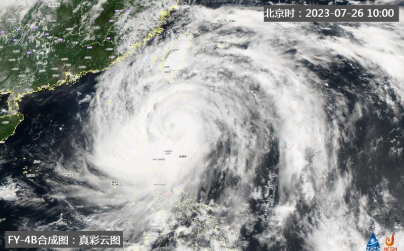
🔹 This morning, Typhoon Dussuri had a massive cloud system and a complete structure. Residents in many places are on high alert. According to reports, on the 26th, many supermarkets in Xiamen, Fujian Province experienced citizens hoarding daily necessities in advance, with sales of mineral water, instant noodles, vegetables, and other items being relatively high.
Wang Xiurong, Chief Meteorological Service Expert of the Public Meteorological Service Center of the China Meteorological Administration, reminded that people affected by the typhoon or preparing to travel to the affected area should closely monitor the official weather forecast and warning information. Moreover, it is currently the peak season for summer tourism, with a large number of tourists from various regions. The public needs to make good itinerary arrangements and take defensive measures. Before and after the arrival of the typhoon, the wind and rain are strong and destructive. The public should try to reduce or avoid going out to play, especially in areas involving mountains and water, and avoid staying under activity plants, shantytowns, and billboards.
Wang Xiurong stated that fishermen and offshore workers should also be reminded to return to the port as soon as possible to take shelter, and coastal aquaculture and crop growers should be reminded to take timely protective measures to avoid economic losses caused by typhoons.


