How many Chinese trees are there? Satellite tells you ->Forest and Grass | Ecological Area | Chinese People
Today is the 29th World Day to Combat Desertification and Drought. The reporter learned from the National Forestry and Grassland Administration that since the 18th National Congress of the Communist Party of China, China has continuously increased its efforts in desertification prevention and control, and has achieved significant results in desertification prevention and control.
Significant achievements have been made in desertification prevention and control in China
This is the high-resolution remote sensing image monitoring platform of the National Forestry and Grassland Administration. The large screen displays a comparison of remote sensing satellite images of the same area on the southern edge of the Taklamakan Desert in 2010 and 2022.
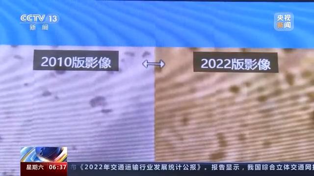
Sun Tao, Director of the Desertification Department of the Forestry and Grassland Survey and Planning Institute of the National Forestry and Grassland Administration: The images from 2010 were relatively dark, with only scattered plant distributions on them. The images in 2022 have clearly turned green, and vegetation has been restored. From the comparison of these two images, it can be seen that our sand prevention and control measures have achieved significant results.
Since the 18th National Congress of the Communist Party of China, China has completed a total of 20.33 million hectares of sand prevention and control tasks, and 53% of the desertified land that can be treated has been treated. The area of desertified and desertified land has decreased by 5 million hectares and 4.33 million hectares respectively compared to ten years ago, and the average vegetation coverage in sandy areas has increased by 2.6 percentage points. The overall improvement and acceleration of ecological conditions in desert areas, as well as the enhancement and stabilization of desert ecosystems. China has achieved the United Nations goal of zero growth in land degradation by 2030 ahead of schedule.
Tu Zhifang, Deputy Director of the Department of Desertification Prevention and Control of the State Forestry and Grass Administration: After long-term exploration and improvement, China has initially established a project construction system focusing on the construction of the Three-North Shelterbelt Program system, Beijing Tianjin sandstorm source control, water and soil conservation and other projects, an assessment system focusing on the responsibility assessment and forest leader system assessment of the provincial government's desertification prevention and control objectives, and an investigation and monitoring system focusing on desertification, desertification and rocky desertification.
In addition, as a contracting party to the United Nations Convention to Combat Desertification, China actively fulfills its obligations under the Convention, promotes the process of the Convention, promotes international exchanges and cooperation, showcases its image as a responsible major country, and has won widespread praise from the international community.
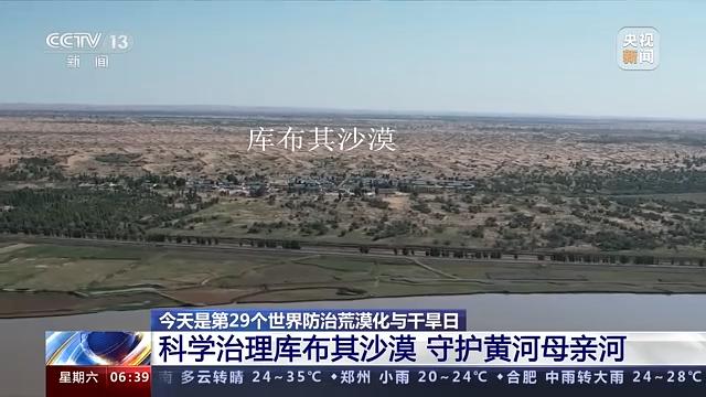
Scientific Governance of the Kubuqi Desert and Protection of the Yellow River Mother River
The Kubuqi Desert is one of the eight major deserts in China, located on the southern bank of the Yellow River, which has the highest latitude at the bend of the Yellow River. "Kubuqi" is Mongolian, meaning the string on a bow. The Kubuqi Desert is like a basin of sand hanging above the Yellow River. Managing the Kubuqi Desert well is crucial for protecting the mother river of the Yellow River.
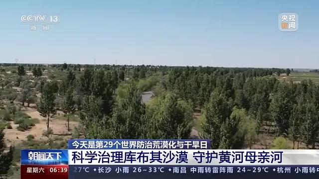
In midsummer, when looking down from a high altitude at the Dugui Tara section of the Yellow River in Hangjin Banner, Inner Mongolia, the lower part of the screen is the Yellow River, and the golden one above the screen is the Kubuqi Desert, one of China's eight major deserts. Here, the Yellow River runs parallel to the Kubuqi Desert, and the closest distance between the desert and the Yellow River is less than 1 kilometer. In the middle of the Yellow River and the Kubuqi Desert, a green barrier firmly locks the yellow sand on the south bank, which is the northern Kubuqi windbreak and sand fixation forest belt.
Since the 18th National Congress of the Communist Party of China, a series of ecological projects have been implemented in the area, including the control of wind and sand sources in Beijing and Tianjin, the second phase of natural forest protection, and the return of farmland to forests and grasslands. A 220 kilometer long lock-in forest belt has been built between the Yellow River and the Kubuqi Desert, and a "181 tree shrub grass" ecological sand control model with shrubs as the main body and trees and grass as supplements has been summarized.
Wang Wenbiao, Secretary General of the Kubuqi International Desert Forum: 10% trees, 80% shrubs, and 10% herbs.
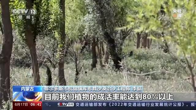
In order to scientifically prevent and control desertification, a desert ecological big data platform has been established in the local area, which accurately implements sand control seed selection and planting planning, gradually exploring the idea of "transforming nature with nature and using ecology to govern ecology". The water vapor planting method has been innovatively invented, using a special water gun to instantly drill holes in the sand through water pressure. Digging pits, planting trees, watering, and covering soil can be completed in one go, and a tree can be planted in just over ten seconds.
Li Ting, a desertification control engineer in Kubuqi Desert, Hangjin Banner, Ordos City: With the combination of multiple technologies, we have formed our current desertification control system, and the survival rate of our plants can reach over 80%.
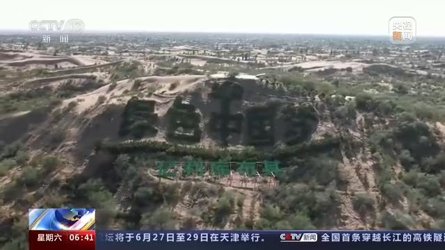
According to remote sensing satellite images from the Chinese Academy of Sciences over the past 35 years, since 1988, the red flowing desert area of the Kubuqi Desert on the south bank of the Yellow River has been relatively large. With continuous governance, the red color has decreased and the green color has gradually increased. Since 2018, the speed of governance has been increasing, and green has become the main color tone in the northern part of the Kubuqi Desert.
Wang Wenbiao, Secretary General of the Kubuqi International Desert Forum: In the past decade, about one-third of the Kubuqi Desert has been greened, with vegetation coverage reaching 65%, an increase of more than 30% compared to 10 years ago. There are 1026 species of organisms, and mobile sand dunes have been comprehensively curbed, safeguarding the ecological security of over 200 kilometers of the Yellow River's "zigzag bend".
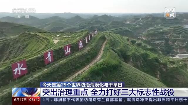
Highlighting the Key Points of Governance and Striving to Fight Three Iconic Campaigns Well
The period from 2021 to 2030 is the construction period of the sixth phase of the Three North Project, which is a key period for consolidating and expanding the achievements of sand prevention and control, and a crucial period for promoting the high-quality development of the Three North Project. Next, the Three North Project will highlight the key points of governance and make every effort to win the three iconic battles.
Firstly, we must make every effort to fight the battle against the "bend" of the Yellow River. The "bend" of the Yellow River is a key area for ecological protection and high-quality development in the Yellow River Basin, with severe soil erosion and desertification. The National Forestry and Grassland Administration stated that it will focus on the Maowusu Desert, Kubuqi Desert, Helan Mountain, and other areas, comprehensively implement regional projects for the management of mountains, rivers, forests, fields, lakes, grasslands, and sand systems, accelerate the management of desertified land, improve forest and grass coverage, protect and restore the rivers, lakes, wetlands, and natural grasslands in the Hetao Plain, and enhance the ability to prevent and control desertification and conserve water sources.
Feng Deqian, Director of the Three-North Shelterbelt Program Construction Bureau of the State Forestry and Grass Administration, said that the second is to fight the battle of annihilation of the Horqin and Hunshandak sandy lands, which are the nearest source of sand and dust to Beijing. We should scientifically deploy ecological protection and restoration projects to achieve full coverage of regional controllable sandy land, increase forest and grass management and restoration efforts according to local conditions, and repair and improve degraded forest and grass resources and wetland resources.
The third is to make every effort to fight the blockade battle on the edge of the Hexi Corridor Taklamakan Desert. Hexi Corridor Taklimakan Desert edge is an important strategic channel of the "the Belt and Road" initiative. The region is windy and sandy, with sparse vegetation, and is the main source area of sand and dust in the north. The State Forestry and Grass Administration said that next, we should make great efforts to comprehensively protect the natural forest and grass vegetation in the Qilian Mountains, Tianshan Mountains, Altay Mount Taishan Mountains, Helan Mountains, Liupan Mountains and other regions, strengthen the construction of wind proof and sand fixation forest and grass belts at the periphery of oases and the edge of deserts, and ensure the stability and non-proliferation of sand sources.
Ministry of Natural Resources: China's terrestrial ecological zones are divided into three levels
Yesterday, the Ministry of Natural Resources announced that the national terrestrial ecosystem will be divided into 6 primary ecological zones, 47 secondary ecological zones, and 233 tertiary ecological zones at different regional scales.
The Ministry of Natural Resources stated that China's terrestrial ecosystem is divided into six primary ecological zones, including the Northeast Ecological Zone, the Yellow River Key Ecological Zone, the Yangtze River and Sichuan Yunnan Key Ecological Zone, the Southeast Ecological Zone, the Qinghai Tibet Plateau Ecological Zone, and the Northwest Ecological Zone.
A secondary ecological zone is a further division of a primary ecological zone, mainly aimed at monitoring and evaluating ecological issues and risks at the regional landscape scale, as well as evaluating the effectiveness of ecological restoration in terms of ecological structure, pattern, quality, function, and other aspects. There are 47 secondary ecological zones in China's land ecosystem, including the Greater Xing'an Mountains ecological zone, the Shandong Jiaodong hilly ecological zone, and the Jiangsu Anhui Yangtze River Delta plain ecological zone along the Yangtze River.
The third level ecological zone is the most basic unit for carrying out ecological monitoring, evaluation, and early warning, mainly aimed at setting up ecological restoration reference systems, formulating regional ecological restoration guidelines, evaluating and simulating ecological restoration capacity, etc. There are 233 tertiary ecological zones in China's land ecosystem, including the northern farmland and wetland ecological zone of the Sanjiang Plain, the Jiaodong hilly farmland ecological zone, and the Poyang Lake Plain farmland and wetland ecological zone.
The Ministry of Natural Resources stated that this ecological zoning is based on the natural geographical pattern and draws on the achievements of China's ecological geographical zoning and ecological function zoning. It analyzes relevant data such as climate, topography, soil, vegetation, geology, and the Third National Land Survey, Ecological Geological Survey, and Groundwater Resources Survey. Using spatial analysis technology, remote sensing comprehensive interpretation technology, and field verification, multiple schemes are compared and comprehensively determined to determine the zoning.