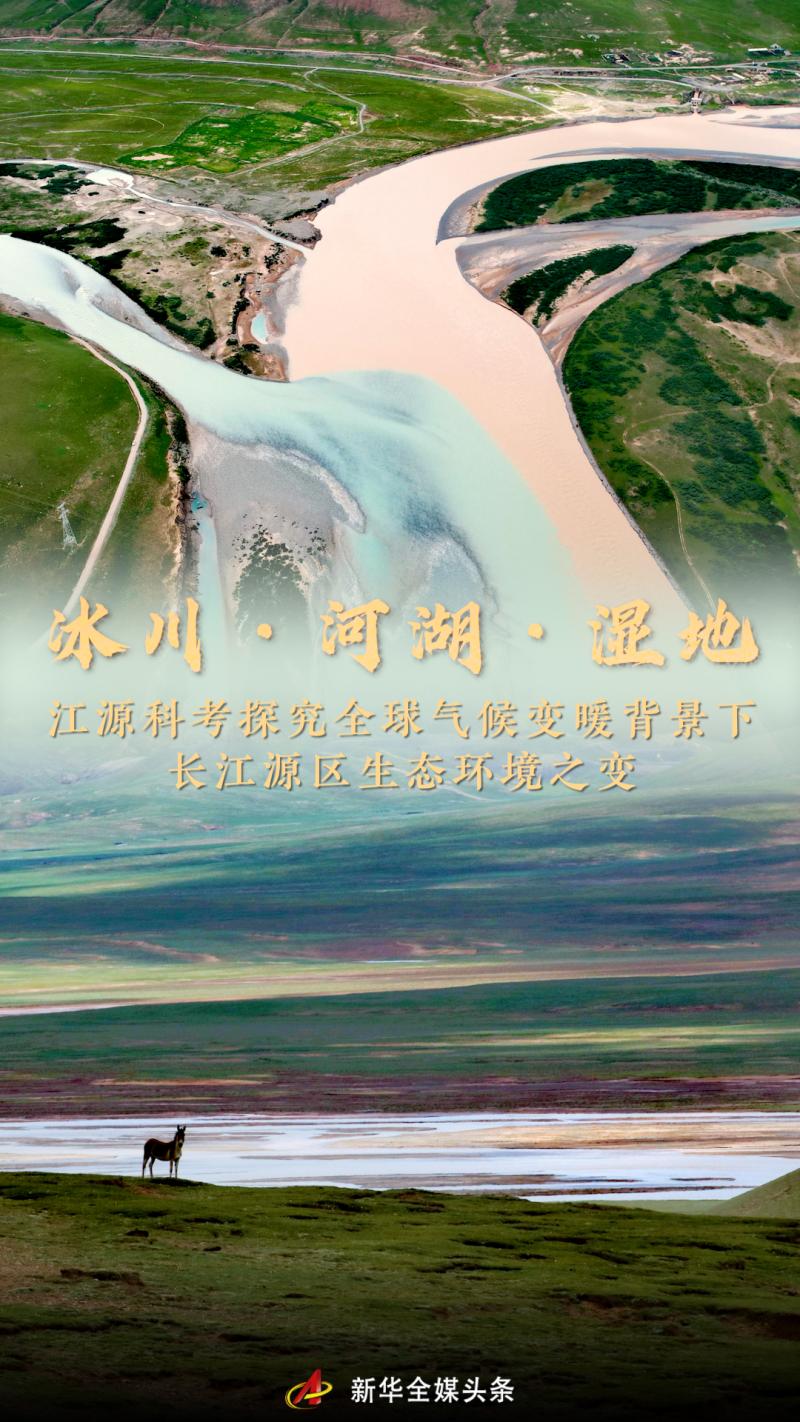
Glaciers, Rivers, Lakes, Wetlands - Exploring the Changes in Ecological Environment of the Yangtze River Source Area under the Background of Global Climate Warming
The source of the Mangmang River has endless mysteries.
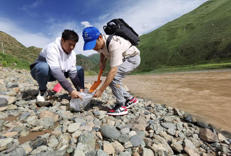
The 2023 Jiangyuan Comprehensive Scientific Expedition Team recently delved into the hinterland of the Qinghai Tibet Plateau and conducted scientific research in the Yangtze River source area with an average altitude of over 4500 meters. During the scientific expedition spanning about 4000 kilometers, 23 team members collected different samples, conducted various observations, and interpreted the mysteries of Jiangyuan.
The source area of the Yangtze River is a sensitive response area to climate change and a fragile ecological environment. What impacts will global climate change have on the ecological environment of Jiangyuan? This scientific examination focuses on glaciers, rivers, lakes, and wetlands, conducting a physical examination of the water environment and ecology in the source area of the Yangtze River, understanding the ecological background of the source area, and identifying the patterns of changes in the source area, providing more scientific support for the protection of the Yangtze River.
Glacier Exploration: Analyzing the Changes of Glaciers in Jiangyuan under the Background of Global Warming
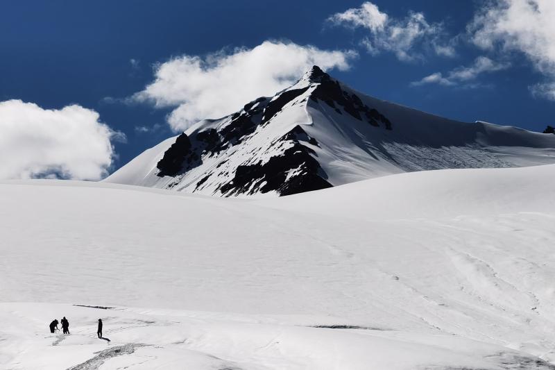
The scientific expedition team conducted geological radar detection on the main peak glacier of Gladan East Snow Mountain. Photo by Xinhua News Agency reporter Liu Shiping
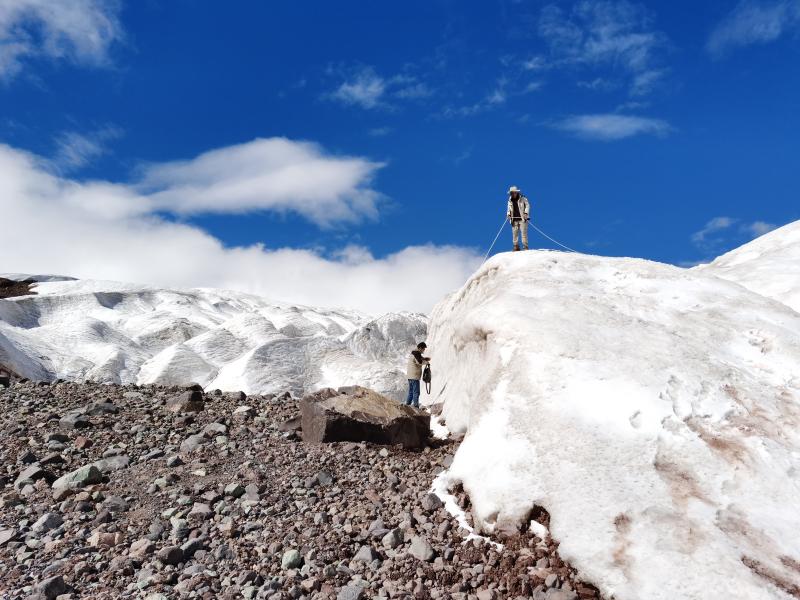
At the foot of Gladan East Snow Mountain, with an altitude of over 4700 meters, expedition team members Dong Shiqi, Fan Yue, and their teammates carried over 30 kilograms of radar equipment and headed towards the main peak glacier. They rely on ice claws and ropes to assist in climbing and pulling out glaciers exceeding 5400 meters, laying measurement lines, recording radar signals every half meter, and detecting glacier thickness based on radar data.

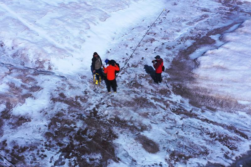
Scientific expedition team members Dong Shiqi and Fan Yue conducted geological radar detection near the Chumar River in the northern source of the Yangtze River. Photo by Xinhua News Agency reporter Chen Jie
The 2023 Jiangyuan Comprehensive Scientific Examination will be led and organized by the Yangtze River Science Academy of the Yangtze River Water Resources Commission of the Ministry of Water Resources, in collaboration with multiple units, to conduct investigations on water resources and aquatic ecological environment in the Yangtze River source area. Since 2012, the annual Jiangyuan Comprehensive Scientific Examination has been one of the most frequently conducted and widely covered scientific research activities in the Yangtze River source area.
Glaciers, known as "solid reservoirs," are important freshwater reserves worldwide and sensitive indicators of climate change.
"This is our second time climbing the main peak glacier of Gladan East Snow Mountain, and we conducted radar detection on four measurement lines in the area measured last year." Dong Shiqi said that last year, the average thickness of glaciers in the measurement area was about 12 meters. The results of this detection can be used to compare the thickness changes of glaciers and accumulate data for calculating ice reserves.
Xu Ping, Chief Engineer of the Yangtze River Academy of Sciences, introduced that this year, radar will be used to detect the main peak glacier of Gladan East Snow Mountain and another glacier in the source area of the Yangtze River, the Dongkemadi Glacier. By mastering the thickness of the glacier at the detection location and combining with previous accumulated data, the ice storage in the detection area will be more accurately calculated, and the impact of climate change on glaciers will be studied.
The scientific expedition team used ground penetrating radar to detect the thickness of the Dongkemadi Glacier on the ice surface. Photo by Xinhua News Agency reporter Chen Jie
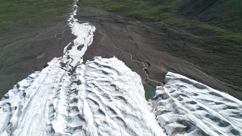
Research shows that global mountain glaciers are generally in a state of retreat. Over the past half century, nearly 6000 small glaciers have disappeared in China, with most glaciers shrinking. Glaciers in the source region of the Yangtze River are generally in the state of end retreat, area reduction and thickness thinning.
The tail of the Dongkemadi Glacier. Photo by Xinhua News Agency reporter Liu Shiping
In recent years, the Yangtze River Academy of Sciences and the Northwest Institute of Ecological Environment and Resources of the Chinese Academy of Sciences have jointly carried out a "space sky earth" three-dimensional observation of the Dongkemadi Glacier. It is reported that the Dongkemadi Glacier has been continuously melting in recent years. After retreating and decomposing into two glaciers, the large and small Dongkemadi Glacier, in 2009, the ice tongue at the front of the glacier is still retreating.
In 2023, members of the Jiangyuan scientific expedition transported scientific equipment with ropes at the Dongkemadi Glacier in the source area of the Yangtze River. Photo by Xinhua News Agency reporter Li Jinfeng
Experts point out that global warming is the main reason for glacier retreat in the source area of the Yangtze River. Monitoring shows that the warming rate in the source area of the Yangtze River has significantly accelerated in the past 20 years, and the annual average temperature in the past 10 years has increased by 1.4 degrees Celsius compared to the average temperature in the previous 40 years.
"Affected by global warming, glacier melting and retreat are intensifying, which can easily lead to seasonal floods, ice avalanches and other disasters. At the same time, when glacier melting reaches a turning point, the replenishment function of river runoff is weakened or even lost, which can also trigger a series of ecological problems." Hong Xiaofeng, a scientific research team member and deputy chief engineer of the Water Resources Research Institute of the Yangtze River Academy of Sciences, said that observation and research on glacier changes need to be further strengthened.
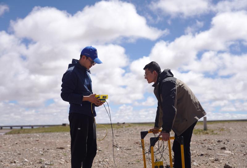
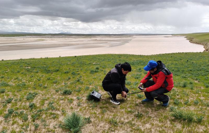
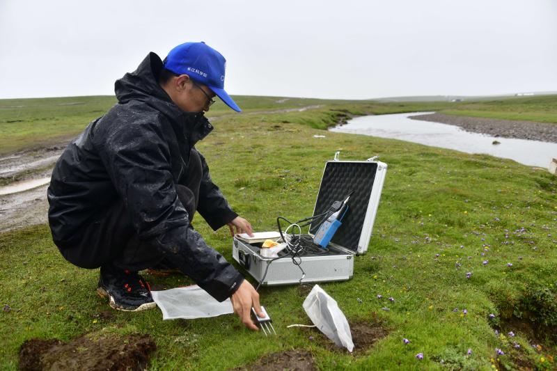
Hong Xiaofeng, a scientific expedition team member from the Water Resources Research Institute of the Yangtze River Academy of Sciences, and his teammates observed soil index parameters at Nangjibalong in the source area of the Yangtze River. Photo by Xinhua News Agency reporter Li Jinfeng
At present, the combination of manual observation and automatic monitoring in scientific research projects such as glacier observation in the source area of the Yangtze River has led to an increasing number of scientific research units participating in automatic monitoring, and the monitoring content is becoming increasingly rich. This will provide more basic data and scientific strategies for ecological change research and protection management in the source area of the Yangtze River.
Observation of rivers and lakes: Revealing the relationship between water ecological environment and changes in river runoff
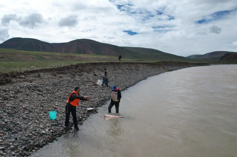
In this year's scientific expedition, Liu Han, a team member from the Institute of Water Environment of the Yangtze River Academy of Sciences, collected samples of river source fish species such as the naked bellied leafy whisker fish and the small headed naked split gill fish. In recent years, he and his colleagues have repeatedly discovered the Siji Plateau loach in the Dangqu area of the southern source of the Yangtze River, which has been confirmed as the "sixth species of fish" in the southern source of the Yangtze River, increasing the number of known fish species in the southern source from 5 to 6.
The scientific expedition team members are conducting observation work in Dangqu Wetland. Photo by Xinhua News Agency reporter Liu Shiping
Li Wei, the leader of the Innovation Team for Key Fish Habitat Research at the Yangtze River Source of the Yangtze River Academy of Sciences, introduced that the average altitude of the southern source of the Yangtze River exceeds 4500 meters, with high cold and oxygen deficient conditions. The detection of new indigenous fish indicates that the ecosystem of the Yangtze River source water continues to improve, and fish diversity may still increase.
Fish are indicative species in the ecosystem of the Yangtze River source, with a high fish integrity index, indicating that the ecosystem of the Yangtze River source water is relatively healthy. According to data from the ecological department of Qinghai Province, the water quality in Qinghai, the main stream of the Yangtze River, has maintained a good condition of Class I to Class II for many years.
The water quality remains excellent, and the runoff of rivers in the source area of the Yangtze River is also significantly increasing.
The scientific expedition team is conducting scientific research assignments on the rivers in the source area of the Yangtze River. Photo by Xinhua News Agency reporter Liu Shiping

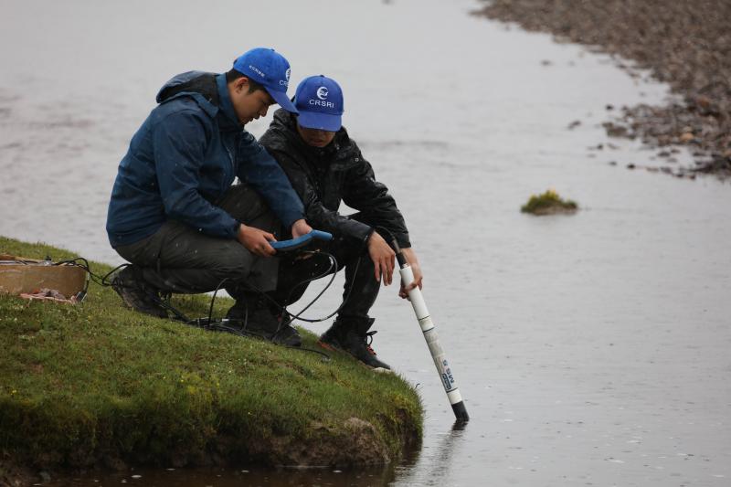
Xu Zhicheng and Yang Xuhai, research team members from the Institute of Rivers at the Yangtze River Academy of Sciences, collect sediment and suspended sediment samples at each sampling point, measure river width, depth, gradient, and flow velocity, compare previous scientific observation data, and analyze the characteristics of water and sediment transport and riverbed evolution in the Yangtze River source area.
Xu Zhicheng, a scientific expedition team member from the Institute of Rivers at the Yangtze River Academy of Sciences, and his teammates collected sediment from the riverbed of the Tongtian River in the Zhimenda section. Photo by Xinhua News Agency reporter Li Jinfeng
The Zhimenda Hydrological Station, located in Xiewu Town, Chengduo County, Qinghai Province, is guarding the main flow of the Yangtze River at the outlet of the Tianhe River. It reports a total area of approximately 137700 square kilometers of the Yangtze River basin, and the hydrological data is considered a representative of the overall hydrological situation in the Yangtze River source area.
According to Yun Jinzhao, a scientific research team member from the Zhimenda Hydrological Station, monitoring data shows that the annual average runoff of the Tianhe River in the Zhimenda section of the upper reaches of the Yangtze River in the past 10 years is 16.7 billion cubic meters, and the annual sediment transport is 12 million tons, which is 24.6% and 20% higher than the annual average values from 1967 to 2000, respectively. This means that the overall runoff and sediment concentration of the rivers in the source area of the Yangtze River have shown a significant increase.
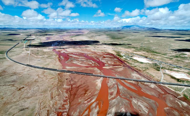
Zhou Yinjun, Deputy Director of the Institute of Rivers at the Yangtze River Academy of Sciences, stated that in recent years, due to the significant increase in runoff and sediment transport driven by climate warming, the lateral expansion of braided rivers in the source area of the Yangtze River has continued to strengthen, and the water flow path has become more free and scattered. Local riverbanks have been eroded and retreated, and the area of river flow has increased.
Affected by global climate change, the area of lakes in the source area of the Yangtze River is also increasing. Taking Quemocuo as an example, this lake, located about 26 kilometers from the front of Gladan East Snow Mountain, had an area of less than 80 square kilometers in 2000. Currently, its total area has reached about 100 square kilometers, with an average annual growth rate of nearly 1%.
Experts point out that the increase in river runoff and lake area, as well as the maintenance of good water quality, is conducive to improving the water ecological regulation and storage capacity of the Yangtze River source area, and better protecting biodiversity. However, there are also some hidden dangers that require continuous attention and in-depth research.
Zhou Yinjun stated that the strong erosion of braided rivers, combined with the expansion of lake areas, will pose a certain threat to the safety of infrastructure such as roads, bridges, oil and communication pipelines near rivers and lakes. Measures need to be taken to actively respond in the construction and operation of infrastructure in the source area of the Yangtze River.
Wetland research: enhancing scientific understanding of high-altitude wetlands on the plateau
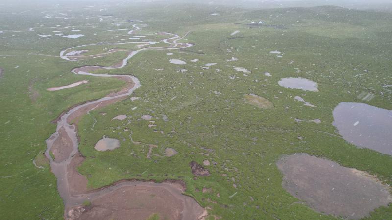
Dangqu Wetland in the midst of wind and snow. Photo by Xinhua News Agency reporter Liu Shiping
The Dangqu Chadan Wetland, with an average altitude of around 4600 meters, is the largest wetland in the source area of the Yangtze River.
At Chadan Wetland, Zhang Shuangyin, a scientific expedition team member from the Institute of Space Information Technology Application of the Yangtze River Academy of Sciences, collaborated with his teammates to circle a 1-square-meter square grassland plot with ropes and collect vegetation samples within the plot; Insert a cylindrical ring knife into the ground and collect soil samples. These vegetation and soil samples will be sent back to the laboratory for unified analysis of carbon content.

Zhang Shuangyin, a research team member from the Institute of Space Information Technology Application at the Yangtze River Academy of Sciences, observed soil indicators in the Dangqu Chadan Wetland during wind and rain. Photo by Xinhua News Agency reporter Li Jinfeng
"We collected more than 100 samples at the Chadan Wetland, covering four types of carbon storage carriers: 'water soil vegetation sediment'. Zhang Shuangyin said that in the future, we will combine remote sensing images and in-situ monitoring to establish a scientific model to estimate the carbon storage of the Chadan Wetland, exploring the way to understand the carbon storage 'foundation' of the Yangtze River source.".
Plateau wetlands are habitats for various rare animals and plant growth areas, with ecological functions such as water storage, water supply, climate regulation, carbon sequestration and sink enhancement. They play an important role in maintaining the ecological balance of the Qinghai Tibet Plateau and purifying the water quality of river sources.
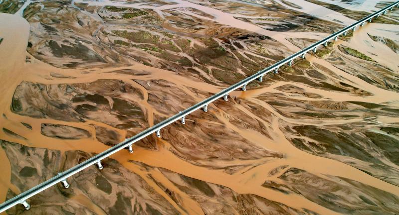
The Qinghai Tibet Railway passes through the Tuotuo River in a braided channel. Photo by Xinhua News Agency reporter Liu Shiping
Liu Han stated that the Dangqu River Basin, with wetlands as the main form, is the region with the richest biodiversity in the source area of the Yangtze River. In recent years, he has monitored the highest density, biomass, diversity index, and abundance of collected fish in the source area of the Yangtze River.
"Analyzing the ecological response of wetlands under climate change conditions can better enhance scientific understanding of high-altitude and cold wetlands." Xu Ping said that strengthening wetland monitoring and scientific research has important reference value for the protection of wetland ecosystems in the source area of the Yangtze River, as well as wetland resource management and rational utilization.
The Qinghai Tibet Railway trains pass through the Chumar River, the northern source of the Yangtze River, in a braided channel. Photo by Xinhua News Agency reporter Liu Shiping
Global warming also has a series of impacts on wetlands in the source area of the Yangtze River. During scientific research, it is common to see high and low undulating, semi-circular frost heave mounds in high-altitude wetlands, with sliding and collapsing phenomena around them. In many low-lying areas, soil and water pits of varying sizes also appear.
"This is a typical freeze-thaw cycle change and local micro geomorphological change caused by permafrost melting." Ren Feipeng, a scientific research team member from the Yangtze River Academy of Sciences, said that the increase in temperature has caused significant changes in the depth and range of the active layer of permafrost in the source area of the Yangtze River. Many permafrost has transformed into seasonal permafrost, and many permafrost have melted, leading to new soil erosion phenomena such as thermal thawing and collapse. At the same time, permafrost melting can directly cause wetland vegetation degradation and a decrease in water conservation capacity.
Research has found that in the past 40 years, the area of swamp wetlands in the source area of the Yangtze River has also shown a decreasing trend, mainly due to the degradation of permafrost under the background of warming, which gradually leads to the loss of soil moisture and increased evaporation.
The retreat of glaciers, melting of permafrost, increased runoff, and expansion of lakes in the source area of the Yangtze River have become the long-term focus and research focus of scientific research on the source area of the Yangtze River.
"This year marks the 12th year of the normalization of scientific research in the Yangtze River source area. We have collected a large number of precious samples and data around the fields of soil and water, sediment, glaciers, ecology, etc. in the Yangtze River source area. Xu Ping said that we will analyze these samples and data, strengthen the research on the changes in the water environment and water ecology of the Yangtze River source area under global climate change, and provide more ontology data and technological support for the protection of the Yangtze River.".
Text and video posters


