Five questions about Typhoon "Dussuri"! Is the intensity comparable to the super typhoon Moranti? Zhejiang | Taiwan Island | Typhoon
On the morning of July 21, this year's No. 5 typhoon "Du Suri" was generated in the Northwest Pacific Ocean and strengthened to a super typhoon on the evening of the 24th. China Meteorological Administration launched a typhoon emergency response at 9: 00 on the 25th. The Central Meteorological Station issued an orange typhoon warning at 18: 00 on the 25th.
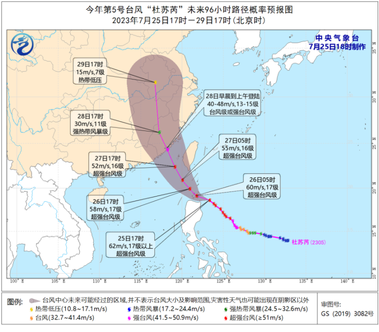
According to the forecast, Typhoon "Dussuri" will enter the northeast sea surface of the South China Sea on the night of the 26th, and will make landfall along the coastal areas from central Fujian to eastern Guangdong in the morning of the 28th.
Many meteorological enthusiasts have compared Typhoon "Du Suri" with the 2016 super typhoon "Moranti", so what are the similarities? "Du Suri" will bring wind and rain to which provinces? The reporter interviewed the Central Meteorological Observatory chief forecaster Gao Shuan Zhu on these topics of public concern.
Question: Which is stronger between "Dussuri" and "Moranti"?
Answer: From the morning to the night of July 24, Typhoon "Du Suri" experienced a process of strengthening from a typhoon level to a super typhoon level. The reason for the strong intensity of typhoon "Du Suri" is that the sea surface temperature of the ocean through which the typhoon passes is relatively high, reaching 28 ℃ to 30 ℃, and the sea surface is relatively wide, which provides sufficient water vapor and energy for the typhoon; secondly, the divergence between the north and south sides of the "Du Suri" high-rise is relatively strong, which brings dynamic conditions for the further strengthening of the typhoon. In addition, the typhoon "Du Suri" was generated in the ocean east of the Philippines on the 21st. Compared with the South China Sea typhoon, this type of typhoon is a certain distance from the mainland of my country, so there is plenty of time to develop and strengthen. This is also the reason for its strong intensity. one.
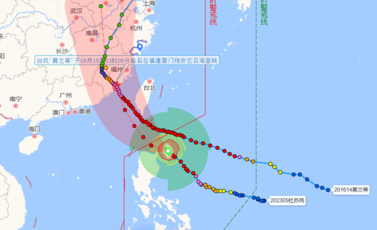
Currently, it appears that "Dussuri" does have similarities in its path with Typhoon Moranti of 2016. However, Moranti passed through the Bashi Strait and was not weakened by the Philippines or Taiwan Island, so it maintained a strong landing intensity and had a positive impact on densely populated cities like Xiamen; However, there is still some uncertainty in the path of "Du Suri". During the peak period of Typhoon Moranti, the maximum wind speed near the center reached 75 meters per second, and compared to it, the intensity of Dussuri was relatively weaker.
Comparison of the Moving Path of Typhoon "Dussuri" with the Moving Path of Typhoon "Moranti" in 2016. Question 2: Will "Dussuri" brush over the Philippines or Taiwan Island of China, and what impact will it have on its intensity?
A: The intensity of typhoons with similar paths when they finally land on the mainland of our country is closely related to whether the form is damaged and whether the intensity is weakened. Due to the large number of obstacles on land and the undulating terrain, affected by land friction, part of the typhoon's energy will be consumed and its intensity will be weakened.
Currently, most forecast models believe that "Dussuri" will pass over the Philippines and Taiwan Island on the 26th and 27th, respectively.
Three questions: Is it difficult to predict the path of "Du Suri" and how will forecasters assess it?
Answer: "Du Suri" is moving towards stability as a whole, but the path is west or east, and there is some uncertainty. Generally speaking, it will make landfall along the coast from central Fujian to eastern Guangdong from the morning to the morning of the 28th at the typhoon or strong typhoon level.
Forecasters usually compare multiple numerical models when studying typhoon paths. This year, in addition to comparing China's CMA-TYM regional typhoon numerical forecasting model with the numerical models of institutions such as the European Medium Range Weather Forecasting Center and the National Environmental Forecasting Center of the United States, the Central Meteorological Observatory also attempted to refer to some AI meteorological large model forecasting systems to determine the most likely direction of the typhoon.
Question 4: Is the wind and rain impact of "Du Suri" significant?
Answer: At present, the structure of "Du Suri" is complete and compact. Compared with other typhoons with scattered cloud types, its wind and rain influence range is relatively concentrated, but the precipitation and wind intensity in the area where the cloud system is passing is large.
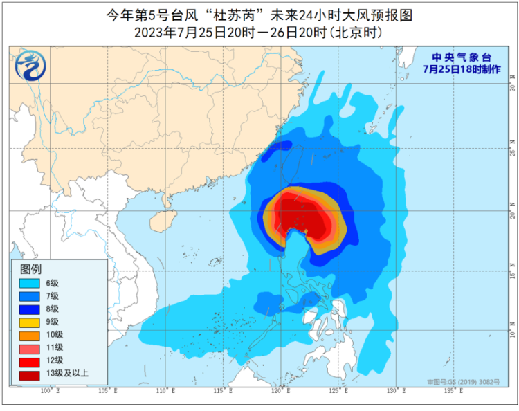
It is expected that on July 26th, there will be winds of force 6 to 8 and gusts of force 9 to 10 in the Bashi Strait, the waters east of Taiwan, the eastern and southern waters of the South China Sea, the Taiwan Strait, Taiwan Island and its coastal areas, and the Fujian coast. Among them, the winds in the Bashi Strait, the waters northeast of the South China Sea, and the waters east of the central and eastern parts of the South China Sea can reach force 9 to 12 and gusts of force 13 to 15. The wind speed in the nearby waters passing through the typhoon center can reach force 13 to 17 and gusts of force 17 or above.
The rainfall brought by Du Suri will mainly affect four provinces: Fujian, Guangdong, Zhejiang, and Jiangxi. From the evening of the 25th to the 26th, there will be heavy to rainstorm in some areas along the southeast coast of Zhejiang, the northeast coast of Fujian, and Taiwan Island, among which there will be heavy rainstorm in some areas in the east of Taiwan Island; From the 26th to the 27th, the eastern and southern parts of Taiwan, the coastal areas of Zhejiang, and the eastern part of Fujian will be affected by rainfall; On the 28th, rainfall continued to affect the eastern coast of Guangdong, Fujian, Zhejiang, eastern and southern Jiangxi, and other areas. The expected period of the strongest rainfall is from the night of the 27th to the 28th.
After the typhoon makes landfall, it is still necessary to closely monitor its direction. Once deep into the mainland, it may also lead to strong rainfall in some inland provinces.
Five questions: What precautions should be taken when a typhoon strikes?
Answer: The meteorological department will strengthen its initiative, interaction, and linkage, and remind relevant regions and departments to do a good job in defense through progressive services and active calls. At the same time, everyone is also the "first responsible person" for their own safety. The public in the areas affected by the typhoon should pay attention to the weather forecast and early warning information in time, cooperate with relevant departments to prevent typhoons, do not go out at will, and stay in a safe place as much as possible. Water operations in relevant waters and passing ships should return to the harbor in time for shelter. To stop indoor and outdoor large gatherings and high-altitude outdoor dangerous operations. In addition, relevant areas should pay attention to preventing mountain torrents and geological disasters that may be caused by heavy rainfall.


