Are you going back to our country again?, Typhoon Kanu is going to make a big turn! Expected to make landfall in South Korea | Kanu | China
Pay attention to typhoons!
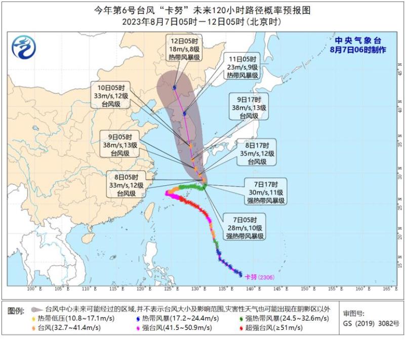
On August 7th at 06:00, the Central Meteorological Observatory continued to issue a blue typhoon warning:
The center of Typhoon Kanu, the 6th typhoon of this year, was located at 5 o'clock this morning in the northwest Pacific Ocean, about 430 kilometers south of Kagoshima, Kyushu, Japan. It is 27.7 degrees north latitude and 130.9 degrees east longitude. The maximum wind force near the center is 10, and the minimum pressure at the center is 970 hPa. The radius of the level 7 wind circle is 320 kilometers, and the radius of the level 10 wind circle is 120-160 kilometers.
It is expected that "Kanu" will slowly move towards the northeast direction at a speed of about 5 kilometers per hour. Starting from the evening of the 7th, it will turn towards the northwest direction in the southwestern sea of Japan, gradually increasing its speed and intensity, and approaching the coastal area of southern Kyushu Island in Japan.
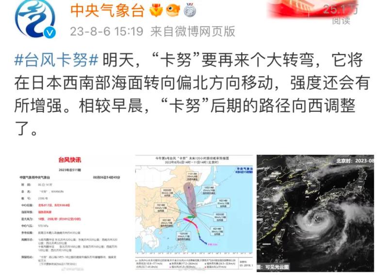
According to the Central Weather Bureau, "Kanu" is about to make another major turn today. It will turn northward in the southwestern waters of Japan and its intensity will also increase. Compared to yesterday morning, the path of "Kanu" in the later stage has been adjusted to the west.
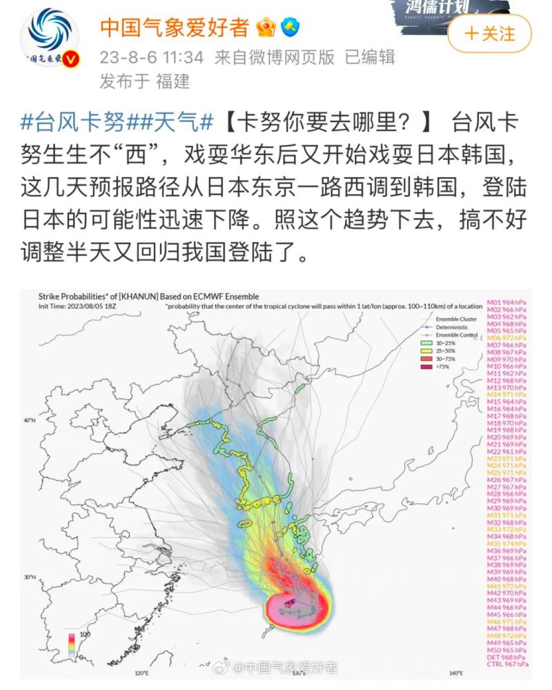
@Chinese meteorological enthusiasts have stated that in recent days, the forecast path has been shifted westward from Tokyo, Japan to South Korea, and the likelihood of landing in Japan has rapidly decreased. If this trend continues, it's possible that after adjusting for half a day, it will return to our country for landing.
The latest news shows that on the 7th local time, according to the South Korean meteorological department, Typhoon "Kanu" is expected to make landfall along the southern coast of Gyeongsangnam do on the morning of the 10th local time. It is predicted that after landing, "Kanu" will continue to move northward, bringing strong winds and rainfall to the whole of South Korea.
This week, the Northeast region of China may be affected by its residual circulation. Friends who plan to visit the Northeast region during the summer should make a travel plan in advance. But currently, the time frame is far away and requires close attention!
High temperature weather returning
The afternoon cooling tool has also arrived
In the past two days, sunny and hot weather has returned. As the beginning of autumn approaches, will high temperatures continue to drive KPI crazy?
Good news! Starting from today, there will be a significant increase in thunderstorms. This week, the high temperature range in our province has narrowed and the intensity has also eased.
Yesterday was also a hot and scorching day. At 11am, temperatures in many areas of Zhejiang have already exceeded the high temperature line. The long-awaited high temperature warning has also reappeared in the martial arts world.
As of 16:18, the top three high temperatures in the province are Qingtian: 39.1 ℃, Yongjia: 38.9 ℃, and Songyang: 38.8 ℃.
Meanwhile, yesterday's afternoon thunderstorm was quite scattered, and some cooling tools arrived in some places.
For example, in Quzhou, short-time rainstorm occurs in many places. Within one hour of this station in Quzhou, the temperature changes from 37.7 ℃ to 27 ℃,
It has dropped by over 10 ℃.
What about Hangzhou?
According to the analysis of the Hangzhou Meteorological Observatory, due to the gradual departure of Typhoon "Kanu", the high altitude in Hangzhou is controlled by northwest and northerly airflow, and the air is relatively dry. Due to the limited water vapor above, the range of thunderstorms in the afternoon is relatively small.
Although Hangzhou has not been controlled by the subtropical high pressure in the past two days, as long as there are few clouds, good sunshine, and no gentle east wind in the sky during the hot summer season, the high temperature can hardly escape.
High temperature critical strike will not last
Everyone is very concerned, will the scorching summer heat start to hit continuously again?
The meteorological department has sent good news: the high temperature will not continue because the weather situation has undergone significant adjustments again!
The Zhejiang Provincial Meteorological Observatory stated that starting from today, thunderstorms will significantly increase. Therefore, this week the range of high temperatures in our province has narrowed and the intensity has also eased.
Especially starting from August 11th, the highest temperature in the coastal areas of Zhejiang is only above 30 ℃, which is much more comfortable compared to these two days.
For Hangzhou, as Typhoon Kanu has become a hollow typhoon, it was originally expected to move northeastward but instead move northward. The northward airflow on the west side of the typhoon will affect the eastern region of China. During this period, the subtropical high pressure has not rapidly strengthened, and there will not be a whole day of clear skies without clouds.
Starting from the night of the 5th, the low altitude water vapor conditions are better, so starting from the 6th, thunderstorms will be more pronounced. On August 7th, there was a large range of thunderstorms.
It may appear before noon, which can be regarded as a systematic afternoon thunderstorm. During thunderstorms, there are some short-term rainstorm, thunderstorms, gales and other strong convection weather. Please take precautions.

Under the pressure of rain, the highest temperature in Hangzhou will drop to 33 ℃ today. And in the next week, it will be difficult for the highest temperature in Hangzhou to exceed 35 ℃. That is to say, the days of high temperatures in Hangzhou this week are few and far between.
Beginning of Autumn Does Not Equal to Entering Autumn
August 8th is the beginning of autumn. Although it is called "autumn", the beginning of autumn is the third hottest solar term among the 24 solar terms, just like the Great Heat and Minor Heat.
The beginning of autumn does not mean the beginning of autumn in meteorological terms. It only indicates that the hot summer is about to pass, and the high temperature has no intention of subsiding.
In Jiangnan, the beginning of autumn is still in the middle of the summer, and the heat is still unbearable. The true coolness will probably wait until after the White Dew solar term.


