Will it affect Shanghai? There will be 1 to 2 more typhoons in the next ten days, with typhoons rolling in: Typhoon "Taili" has not yet left showers | Weather | Shanghai
Entering the second half of July, the weather seems to have dug a typhoon's nest. Typhoon Tai Li has not yet left, and it seems that a new typhoon is about to form.
According to the mid-term forecast from the Central Weather Bureau, it is expected that there will be 1 to 2 more typhoons generated in the western Pacific in the next 10 days. If two typhoons are generated, according to the typhoon naming sequence table, the typhoons after "Taili" will be named "Dussuri" and "Kanu". The former name comes from South Korea, meaning a bird of prey; The latter name comes from Thailand, meaning jackfruit fruit.
The initial typhoon "Taili" did not have a direct impact on Shencheng, so will the following typhoons affect the East China region? According to predictions, one of them will affect the South China Sea and other regions in the later part of this month. The Central Meteorological Observatory has not yet provided a prediction on whether another typhoon will form and its path trend. Based on public information, the typhoon will not affect Shanghai for the time being.
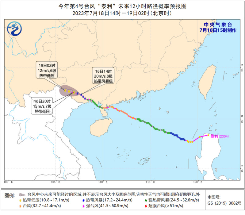
At around 22:20 yesterday, Typhoon Tai Li made landfall along the coast of Nansan Island in Zhanjiang City, Guangdong Province on a typhoon level, becoming the first typhoon to make landfall in China this year, breaking the more than month long typhoon gap in China. Around 5:45 today, it made landfall again in Beihai City, Guangxi with a strong tropical storm level. As of 17:00 today, located in Ningming County, Chongzuo City, Guangxi, it will move towards the northwest direction at a speed of 15 to 20 kilometers per hour, and the intensity will gradually weaken. It is expected to weaken and dissipate in northern Vietnam from tonight to early tomorrow morning.
"Taili" is the fourth typhoon of this year and also the first typhoon of this year, and these two are not contradictory. According to the definition of China's meteorological department, the initial typhoon refers to the first typhoon to make landfall in China every year. Once again, it is not the first typhoon generated, but the first one to make landfall in China.
The appearance time of the initial typhoon is mostly from June to July, with the highest number of landfalls in late June, with 14 landfalls in history at this time; Secondly, there were 12 login records in early July. Occasionally, I also catch up with the morning session, and I checked in as early as mid April. For example, in 2008, Typhoon No. 1 "Huanxiong" made landfall in Longlou Town, Wenchang, Hainan as a strong tropical storm on April 18, becoming the only typhoon to make landfall in China in April since 1949. The latest one was in early August, 1975, which was the latest appearance of a typhoon.
The appearance time of the initial typhoon is mostly from June to July, with the highest number of landfalls in late June, with 14 landfalls in history at this time; Secondly, there were 12 login records in early July. Occasionally, I also catch up with the morning session, and I checked in as early as mid April. For example, in 2008, Typhoon No. 1 "Huanxiong" made landfall in Longlou Town, Wenchang, Hainan as a strong tropical storm on April 18, becoming the only typhoon to make landfall in China in April since 1949. The latest one was in early August, 1975, which was the latest appearance of a typhoon.
So is it better for the initial typhoon to arrive early or late? If viewed from the perspective of strength, earlier is better. Because when the first typhoon was born, the sea surface temperature was often not high enough, so the intensity was limited. As time goes on, the power tends to increase. On August 3, 1975, Typhoon "Nina" landed in Hualien, Taiwan, as a super typhoon, crossed the Taiwan Strait and went inland from Fujian, bringing heavy storms to Taiwan, Fujian, Henan and other places, especially causing serious casualties and economic losses to Henan. This is mainly due to the combination of warm and humid airflow transported into the land and cold air, resulting in extremely strong rainfall, bridge and dam damage, and ultimately flooding in the Huai River Basin.
The main battlefield of the initial typhoon is in the southern and eastern regions of China, from Ninghai in Zhejiang to the Sanmen line in the north, and to Sanya in Hainan in the south. The most favored areas are Guangdong, Taiwan, and Hainan, with Guangdong being the most favored.
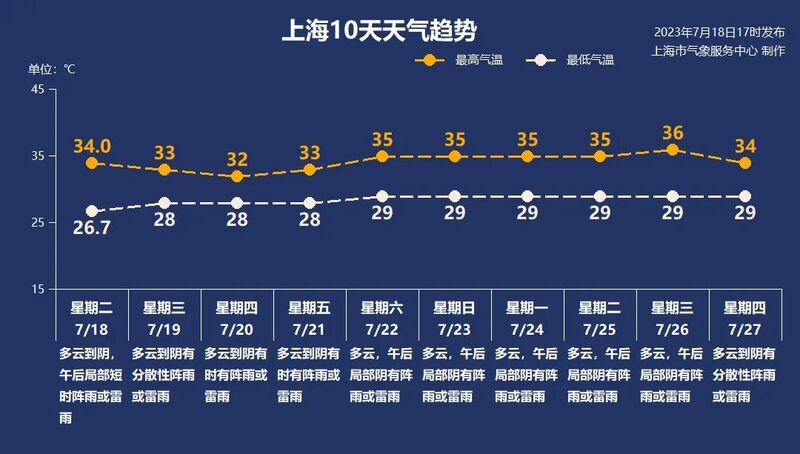
Shanghai is not greatly affected by "Taili". Today, the highest temperature in most areas of the city is around 34 ℃, with the highest being 34.9 ℃ at Minhang Station, 34.0 ℃ at Xujiahui Station in the central urban area, and the coolest being 30.8 ℃ in Chongming. Tomorrow, Shanghai will mainly have cloudy to cloudy weather, with occasional scattered showers or thunderstorms. The temperature will slightly drop compared to today, with the highest temperature being 33 ℃.
The hot weather will once again sweep over the weekend. Starting from Saturday, with the control of the subtropical high pressure, the "sunny and hot sun+afternoon thunderstorm" package will return once again. The highest temperature in Shanghai will remain above the 35 ℃ high temperature line, and afternoon thunderstorms are usually small in scope and short in duration. What really needs to be prevented is the high temperature heat wave.