Why did typhoons cluster in August?, The weather in Shanghai will be complex and variable in the later part of next week, with two typhoons dancing together in the Pacific Ocean | Typhoon | Weather
According to the latest news from the Central Meteorological Observatory, Typhoon No. 10 "Davy" was formed today, forming a "double dance" with Typhoon No. 9 "Sula".
In August this year, typhoons swarmed in, each with strong strength——
At the beginning of August, the No. 6 typhoon "Kanu", which was screened, had an extremely long standby life more than double that of ordinary typhoons, bringing heavy storms to many parts of China.
Following closely behind, Typhoon No. 7, Lan'en, although did not make landfall in the coastal areas of China, reached a super typhoon level in intensity and brought strong winds and heavy rain to Japan, with rainfall in many areas breaking historical records.
Typhoon No. 8, Dora, has a more legendary background. It was born off the coast of West Africa, crossed the Strait of Central America after several twists and turns, became a hurricane in the eastern Pacific, and then traveled a long distance to the northwest Pacific, successfully registered as a typhoon "hukou", becoming the first "imported" typhoon since 2018.
At the end of August, two more typhoons arrived to catch up.
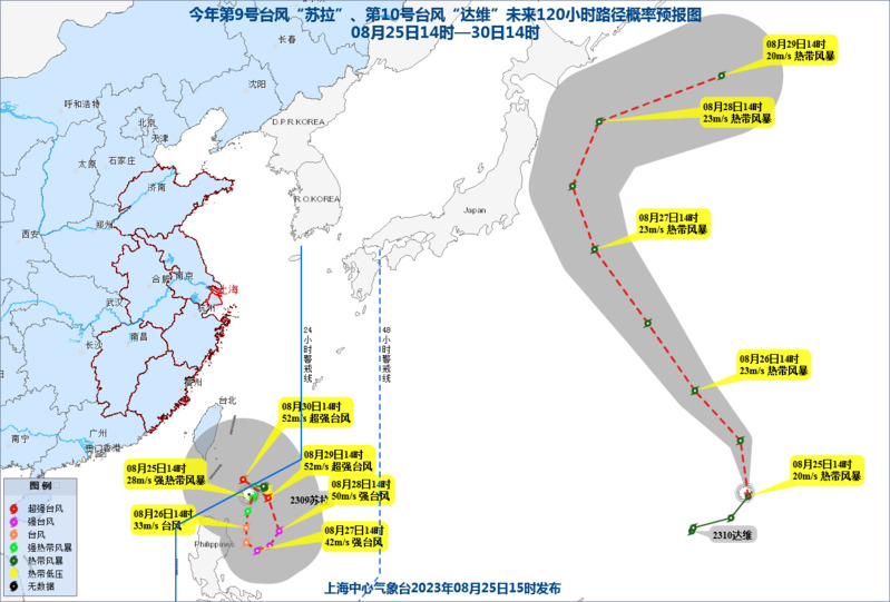
Typhoon Sura, the 9th typhoon, was generated yesterday. The name was provided by Vietnam and means the Central South Antelope, which is a rare animal in Vietnam. "Sula" is not as active as the antelope, and due to the influence of the surrounding situation, its trend can be described as "magic turning circles", and its movement is also slow.
Typhoon Davy, the 10th typhoon, originated from Cambodia and means "elephant". Davy is not as fast as an elephant, but rather very fast. At 17:00 today, "Davy" is about 1270 kilometers northeast of Saipan, Guam, and will move rapidly towards the northwest direction at a speed of about 30 kilometers per hour, with little change in intensity.
How will the twin typhoons affect Shanghai?
The Shanghai center Meteorological Observatory said that the typhoon "Dawei" had no impact on China, but the meteorological department was still paying attention to the trend of "Sura". According to the latest typhoon path forecast, in the next four days, Typhoon "Sula" will remain stationary in the eastern waters of the Philippines and gradually strengthen in intensity.At present, it is not ruled out that "Sula" may move northward into the East China Sea and affect the coastal areas of Zhejiang. It is expected that new tropical systems will emerge in the later stage, which will add more variables to the weather in Shanghai.
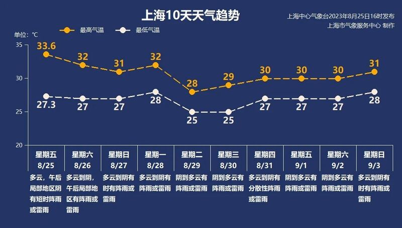
According to the current forecast, there will be showers or thunderstorms in Shanghai on Sunday, with the highest temperature dropping to 31 ℃. From next Monday to Wednesday, there will be a significant rainfall and cooling weather process due to the influence of the high altitude trough and the eastward airflow over the sea. In terms of temperature, the highest temperature can drop below 30 ℃ next Tuesday and Wednesday.
Why did typhoons appear one after another in August this year?
In fact, it is normal for typhoons to concentrate in August. From the perspective of typhoon activity time, typhoons may occur in the Northwest Pacific and South China Sea throughout the year. In China, the time range of typhoon landfall is also very wide, except for January to March when there is no typhoon landfall, there are cases of typhoon landfall in other months. In terms of monthly landfall distribution, the time when typhoons make landfall in China is mainly concentrated in summer and autumn, with the most concentrated period from July to September. Taking typhoons that have landed in China as an example, the proportion of these three months has reached 78%.
This is also easy to explain in meteorology. In August, the high temperature of seawater and the rapid evaporation of water vapor form cumulus clouds, providing favorable conditions for the generation of typhoons. Due to the expansion of the subtropical high pressure system in the western Pacific and the southward movement of the subtropical high line, typhoons are moving southward along the subtropical high line, making coastal areas of China more susceptible to typhoon attacks. The fusion of monsoon airflow and subtropical high pressure makes it easy for typhoons to maintain strong intensity. Therefore, typhoon activity is frequent and fierce in August.
However, this year there has also been an abnormal phenomenon in typhoons, which is the abundant production of super strong typhoons. Marva, Dussuri, Kanu, and Lann have all reached the level of super typhoons at their peak. However, data shows that there are generally two super typhoons born in the northwest Pacific each year, with a significantly higher number this year.