Next week, we will officially respond to the challenge of typhoons. Shanghai has had more rainfall during the flood season this year, and "Du Suri" has stopped operations and is still frantically sprinkling water on typhoons. | Water vapor | Shanghai
The original plan was to pass through the same latitude area of "Dussuri" in Shanghai, but due to its decreasing intensity, it was stopped from being numbered by the Central Meteorological Observatory at 11 noon today. The eye of the typhoon is gone, and the cloud wall is also gone. This super typhoon, which has caused extreme anxiety since its formation on July 21st, has finally become history.
But the residual forces of typhoons cannot be underestimated. Several spiral rain bands can touch northern China and southern China, and also sweep through the eastern region. At noon today, the remaining convective cloud system brought a wave of heavy rainfall to Shanghai, and around 15:00, another wave of rainwater "threw over". From 8:00 to 18:00, the largest rainfall in the city was in Pudong, with a cumulative rainfall of 28 millimeters, followed by Fengxian and Jinshan with 18.9 millimeters and 17 millimeters, respectively.
As of 20:00 yesterday, the cumulative rainfall in the central urban area of Shanghai since the flood season this year has reached 478.4 millimeters, more than 20% higher than the same period in previous years. So there has indeed been a lot of rain this year.
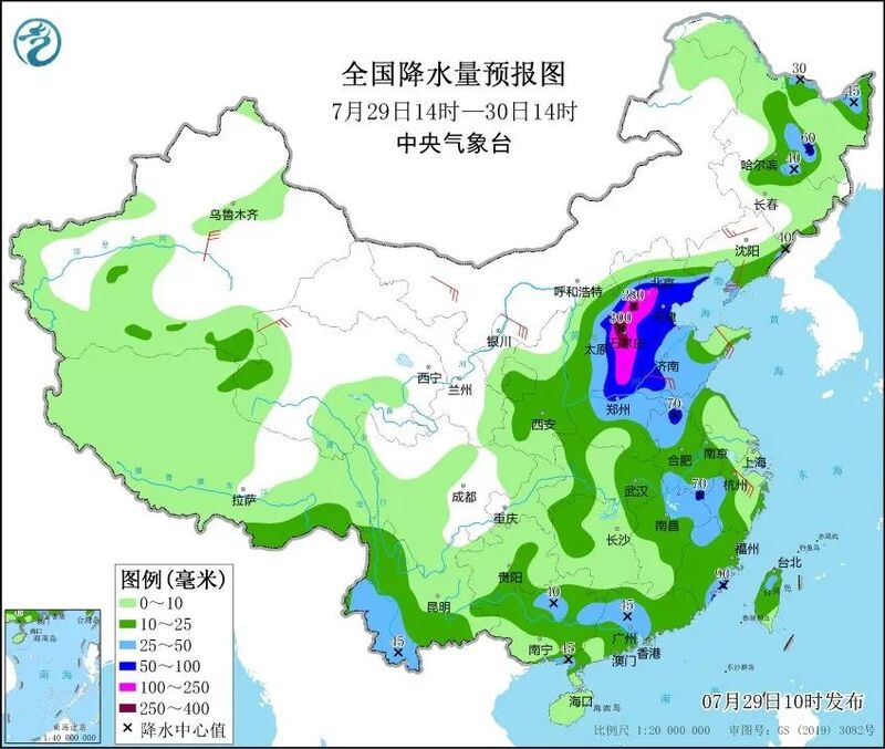
Shanghai is not the home ground for this round of wind and rain. According to the data monitoring of the Central Meteorological Station, the most ferocious rainstorm of "Du Surui" fell on Putian, Fujian Province. In just 30 hours, the accumulated rainfall in 12 regions of Putian exceeded 600 mm, with the maximum rainfall of 758.9 mm. Several areas in Ningde, Fuzhou, Quanzhou, and Xiamen, Fujian also experienced heavy rainfall of over 300 millimeters.
The last rainstorm center was in Fujian, and the next rainstorm center directly jumped to Beijing Tianjin Hebei. In the next three days, the North China Plain will also usher in record breaking extremely heavy rainstorm due to residual clouds.
Perhaps some people are curious: why does the typhoon cloud system not affect coastal areas such as Jiangsu, Zhejiang, and Shanghai, but instead runs inland and northern? In fact, this precisely reflects the complexity of the atmospheric system.
Meteorological experts explain that this is because three streams of water vapor are simultaneously heading towards North China, with residual circulation water vapor from typhoons, water vapor from the periphery of subtropical high-pressure systems, and remote assistance from Typhoon No. 6, Kanu. The presence of water vapor is not enough, and the local area has provided favorable conditions. Now, two high-pressure systems have merged to form a "dam", blocking the movement of precipitation clouds, thus prolonging the time that precipitation stays in the Beijing Tianjin Hebei region. In addition, the local geographical environment, including the Taihang Mountains and the Yanshan Mountains, forces water vapor to be uplifted by the terrain in front of the mountains, resulting in an increase in rainfall intensity.
At present, the Central Meteorological Station has issued a red warning signal for rainstorm. It is expected that from today to August 1st, the cumulative rainfall in some areas of the Beijing Tianjin Hebei region will reach 200 to 450 millimeters, with some areas exceeding 600 millimeters. Both extreme and catastrophic rainfall are rare in history.
As for Shanghai, the influence of "Du Suri" has come to an end today, but we still cannot relax our vigilance. After all, the real typhoon challenge is still next week.
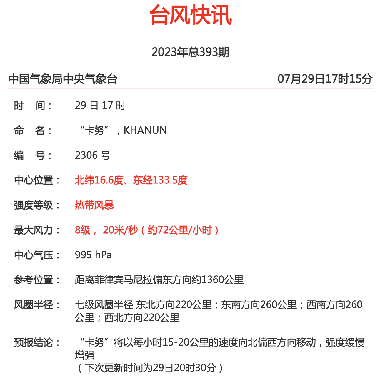
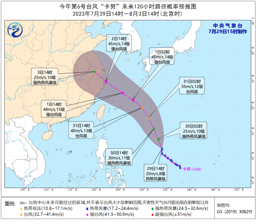
"Du Suri" has been discontinued, and the original "double stage dance" has now become the personal solo of "Kanu". According to the latest typhoon news from the Central Weather Bureau, "Kanu" is about 1360 kilometers east of Manila, Philippines at 17:00 today. It is currently on tropical storm level and its intensity is gradually increasing.
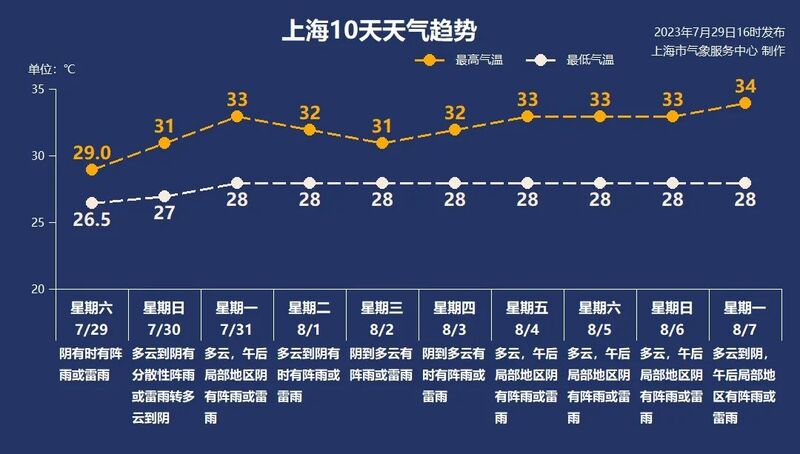
According to the forecast, "Kanu" is gradually approaching the eastern coast of China and deserves close attention. Affected by the "Kanu", the wind force in Shanghai will significantly increase around August 2nd, with showers or thunderstorms, and the highest temperature will drop to 31 ℃ to 32 ℃. Starting from the 4th, cloudy weather will return, with temperatures rising to 33 ℃ to 34 ℃, and thunderstorms in the afternoon will become a frequent summer visitor.
Tomorrow, it will be mostly cloudy to overcast in Shencheng, with scattered showers or thunderstorms, and overall, the precipitation will weaken. The temperature has rebounded, with a minimum of 27 ℃ and a maximum of 31 ℃.