Is there still wind and rain in Shanghai this week?, Typhoon Kanu suddenly turned around and had an impact. To Shanghai | Storm | Kanu
The wind and rain impact of Typhoon Dussuri has not yet ended, and Typhoon Kanu, the 6th typhoon, has quickly taken over.
Today, there are two pieces of information worth paying attention to about "Kanu". Firstly, this morning, "Kanu" erupted rapidly, opened a clear typhoon eye, and its intensity is still increasing; Secondly, "Kanu" suddenly turned around in the East China Sea and did not land in Zhejiang?
According to the Shanghai center Meteorological Observatory, the latest forecast path of "Kanu" has been significantly adjusted compared with the previous one, which is mainly related to the instability of the subtropical high in the future and the active tropical convection on the east side of "Kanu".
As of the time of publication, the new landing point for "Kanu" has not yet been announced. Industry experts say that currently, professional institutions, numerical models, and AI models in various countries are also uncertain about the specific trend of "Kanu". But it can be confirmed that the future circulation of "Kanu" will be huge and strong.
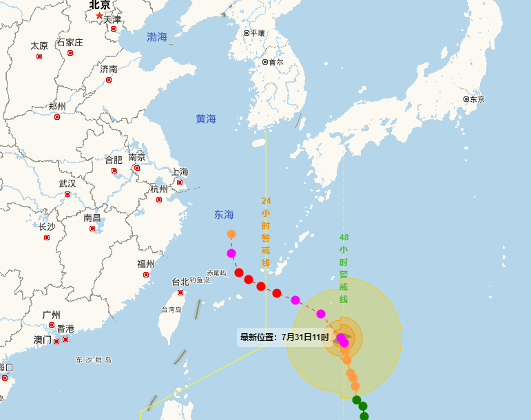
We need to strike the blackboard here and adjust the "Kanu" path, which seems to be far away from the coast of our country, but it does not mean that we can resist Taiwan. According to the latest monitoring by the Central Meteorological Observatory, "Kanu" was located about 600 kilometers southeast of Naha City in the Ryukyu Islands at 11:00 am today, reaching a strong typhoon level with a maximum wind force of 15. It will move northwest at a speed of 15 to 20 kilometers per hour, and its intensity has increased.
What is the concept of 15 level wind power? It can set off rough waves on the ocean. Whether it is landing or continuing northward, early August will inevitably bring significant storms to the East China region.
The Shanghai center Meteorological Observatory predicted that the movement path of Kanu after entering the East China Sea was still uncertain. Based on the current path prediction, Typhoon "Kanu" entered the East China Sea on the night of August 2nd, and its movement speed significantly slowed down thereafter. From August 2nd to 6th, it will have a significant wind and rain impact on the coastal waters of East China.
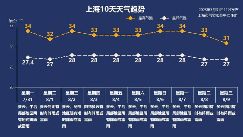
For Shanghai, in early August, under the influence of the "Kanu" periphery, the wind was generally strong and there were also many showers. Is the "typhoon barrier" working again?
Whenever a typhoon passes by Shanghai, the "boundary" in Shanghai always triggers heated discussions. In fact, it is not easy for a typhoon to make landfall in Shanghai. Compared to the narrow coastline of Zhejiang, Fujian, and Guangdong, Shanghai is just a "point". In terms of probability, the probability of this "point" being hit by a typhoon is very small. For example, if a typhoon is basketball and Guangdong is rebounding, then Shanghai is a very small basketball basket, and the probability of hitting the rebounds is naturally higher if you throw the ball casually.
In addition, Shanghai is located to the north and has a relatively high latitude, making it difficult for typhoons to reach. Many typhoons reach the East Sea and gradually cross the subtropical high pressure ridge, creating a feeling of "boundary".
Finally, it should be emphasized that typhoons do not only affect Shanghai when they make landfall. Wiping off the coast also caused strong winds and rain in Shanghai. In super large cities like Shanghai, we must be vigilant against secondary disasters caused by strong winds and rain.