Around noon tomorrow, "Dussuri" will pass through Shanghai at the same latitude, and Shanghai will issue the first blue typhoon warning of the year. Typhoon | Rafale | Warning
At 17:00 today, the Shanghai center Meteorological Observatory issued the first blue typhoon warning signal of this year. Affected by the periphery of Typhoon Dussuri, the 5th typhoon of this year, it is expected that there will be a southeast wind of level 5 and gusts of levels 6 to 7 on land in the next 24 hours, with gusts of level 8 in coastal areas along the river and on rivers and lakes.
This morning, "Du Suri" made landfall along the Jinjiang coast of Quanzhou, Fujian with a strong typhoon level. According to data, this is the strongest typhoon to make landfall in Quanzhou, Fujian since the establishment of the People's Republic of China, and also the second strongest typhoon to make landfall in Fujian since there are complete observation records. At its peak, the cloud system carried by this massive sprinkler covered thousands of kilometers, and many provinces and cities experienced heavy rainfall under its cloud cover.
According to data from the Central Meteorological Observatory at 17:00 today, affected by Typhoon "Dusui", some areas in eastern and southern Taiwan, eastern Fujian, eastern Zhejiang, and other areas have accumulated rainfall of 100 to 250 millimeters. In eastern and southern Taiwan, Wenzhou, Lishui, Ningbo, and Ningde in Fujian have accumulated rainfall of 300 to 700 millimeters. In some areas of Pingtung, Taiwan, the rainfall has exceeded 1400 millimeters; Gusts of 8 to 10 levels appeared along the eastern coast of Fujian, Zhejiang, and Taiwan Island, with localized gusts of 11 to 15 levels.
Typhoon landfall does not mean relaxing vigilance. After landing, although the strength of the "Du Suri" weakened, it was full of power and was constantly moving northward and deep inland. The heavy rainfall it brings will cover Fujian, Zhejiang, Jiangxi, Anhui, Jiangsu, Shanghai, Henan, Shandong, Hebei, Beijing, Tianjin, Liaoning and other areas, and some areas may experience extreme rainfall.
The main body of "Du Suri" is far from Shanghai, but the outer spiral rain belt has a large range and abundant water vapor, and Shencheng is still within the range of "throwing water". The Shanghai center Meteorological Observatory said that "Du Surui" will pass through the same latitude of Shanghai in Anhui around noon tomorrow. Affected by the periphery of the typhoon, it is expected that Shanghai will have occasional showers or thunderstorms from today to Sunday morning, with obvious characteristics of intermittent precipitation. Local areas will have rainfall of 30 to 50 millimeters, and some areas will have rainfall of 60 to 80 millimeters; The strongest impact of strong winds will occur today and tomorrow.
At 2 o'clock today, Typhoon Kanu, the 6th typhoon of the year, also formed deep in the Pacific Ocean. Since the typhoon was officially named in 2000, there have been four "Kanu" events, namely the 15th of 2005, the 7th of 2012, the 20th of 2017, and the 6th of 2023. Coincidentally, the generation location of the first generation "Kanu" in 2005 is similar to that of the fourth generation "Kanu" this year, and the movement path is also similar.
On September 7, 2005, the first generation of "Kanu" was formed on the Pacific Ocean west of Guam, gradually moving northwest and landing along the coast of Luqiao District, Taizhou City, Zhejiang Province. After landing, it moved in a northwest direction, passing through Jiangsu and entering the Yellow Sea. Finally, it weakened into a low pressure and disappeared near South Korea.
During the landing and northward movement of the first generation of "Kanu", it brought significant wind and rain impacts to the coastal areas of Jiangsu, Zhejiang, Shanghai, and Shandong. Due to its landing point in central Zhejiang, Shanghai is located within its dangerous semicircle, with obvious wind and rain.
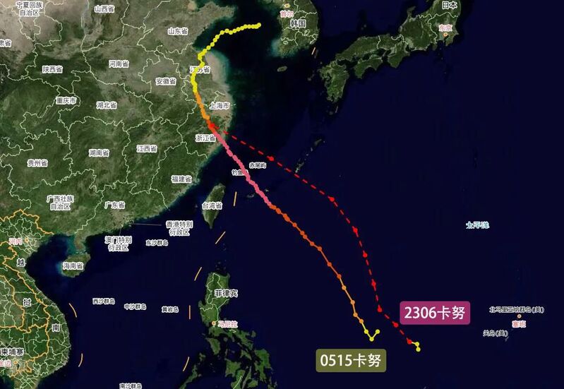
Will the new "Kanu" revisit the old path of a generation? The Shanghai Meteorological Service Center stated that currently, there are still significant differences in the path and intensity prediction analysis of multiple numerical forecasting models worldwide. However, overall, the new "Kanu" will tend towards the eastern coast of China in the future.